Florida Gov DeSantis declares state of emergency ahead of Invest 93L brewing in Gulf of Mexico
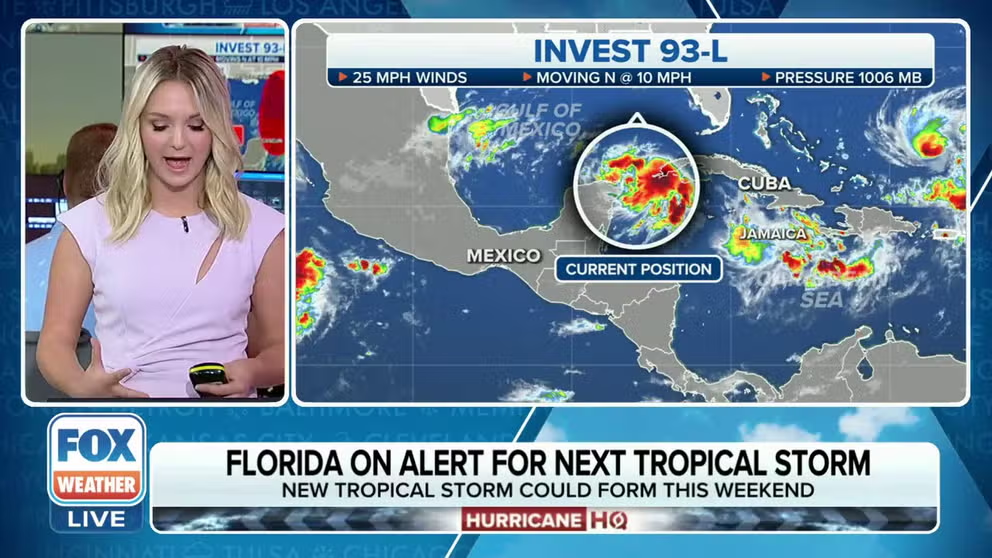
A tropical disturbance in the western Caribbean Sea is now known as Invest 93L. Forecasters say it has a high chance of development. Could Idalia be in the making?
Tropical development chances increase with 93L over the NW Caribbean
The FOX Forecast Center is monitoring 93L which has a 90 percent chance of becoming a tropical cyclone during the next 48 hours.
As of Saturday at 5:00 PM, Tropical Depression Ten has formed near the Gulf of Mexico. Continuous coverage of its path to Florida has moved here.
A tropical disturbance in the northwestern Caribbean Sea and southern Gulf of Mexico is under increased scrutiny as forecasters have dubbed it Invest 93L, giving it a high chance of development and prompting a state of emergency declaration in Florida.
The National Hurricane Center has been tracking the disturbance for a few days. The invest designation means the agency has stepped up its system monitoring, which appears to be headed for the Gulf of Mexico.
The NHC is giving a 90% chance that a tropical depression or tropical storm will form within the 48 hours.

(FOX Weather)
While it’s too early to know for certain where Invest 93L is headed, emergency officials in Florida said they are closely watching the system. It will be named Idalia if it becomes a tropical storm or hurricane.
"Futuretrack also shows that while it may strengthen, it's still uncertain where in the U.S. that this system could impact. So we're going to be watching the Sunshine State very closely and all across the Gulf Coast over the next couple of days," FOX Weather meteorologist Kiyana Lewis said. "Whether we see that in Florida or not, heavy rain in the possibility of flooding is certainly going to be on the table into early next week."
Here’s a closer look at Invest 93L.
Where is Invest 93L?
Invest 93L is located near Mexico's Yucatan Peninsula and is producing plenty of showers and thunderstorms.
The disturbance lacks center of circulation, which is needed for a tropical depression or tropical storm to form.

(FOX Weather)
Where is Invest 93L headed?
It is too soon to know for sure where Invest 93L is headed. Some computer models indicate a Florida landfall, but the forecast will become clearer in the coming days. Now is a good time for everyone along the Gulf Coast to review their hurricane preparedness plan.

(FOX Weather)
"Once this gets going and fully developed, we could see this impact the Gulf Coast, the U.S., possibly the Sunshine State, in a matter of days," Lewis said. "It really wouldn't take much around 2-4 days to see this impact parts of Florida."
Floridians urged to prepare
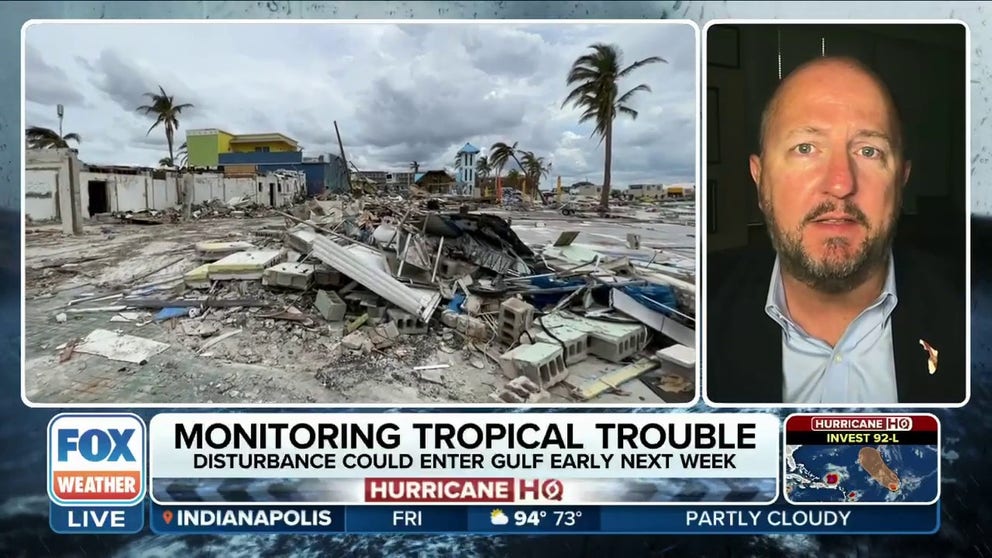
Emergency managers in Florida said they are closely monitoring the system.
"What we're most concerned about right now is a matter of flooding across the (Florida) peninsula," Kevin Guthrie, director of Florida's Emergency Management Division, told FOX Weather on Friday.
Guthrie expressed concern about the possibility of a tropical storm or low-end Category 1 hurricane making landfall in the Nature Coast or Big Bend area just north of Tampa Bay.
NEW TO FLORIDA? HERE’S A GUIDE TO HELP PREPARE FOR YOUR FIRST HURRICANE SEASON
"The Gulf of Mexico is very, very warm right now. So we don't know exactly what we're going to be facing," he added. "But we're going to be prepping over the next three days, over the weekend, as if we were going to be getting a Category 1 hurricane and making those preparations, asking people to listen to their local emergency managers."
The threat of tropical development has Gov. Ron DeSantis urging Florida residents to prepare for any impacts and has issued a state of emergency for half of Florida's 67 counties.
Florida preps for peak hurricane season as threat of tropical development in Gulf of Mexico increases
FOX Weather is tracking a disturbance in the Gulf of Honduras in the western Caribbean Sea. It could track into the Gulf of Mexico if it develops and potentially threaten Florida. Kevin Guthrie, director of Florida's Emergency Management Division, joins FOX Weather from Tallahassee.
Bottom line
Invest 93L appears destined to move into the Gulf of Mexico, but its future strength and if it makes landfall are still uncertain. Everyone along the Gulf Coast should review their hurricane preparedness plan and be prepared to take action if needed. Watch Hurricane HQ on FOX Weather and download the FOX Weather app for the latest information.

(FOX Weather)