Weakening Eugene in Eastern Pacific expected to bring needed rain to California, Southwest
Forecast models indicate that Eugene will continue weakening before sending needed moisture into the desert Southwest.
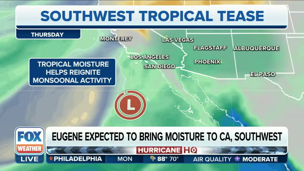
Eugene expected to bring needed moisture to California, Southwest
Tropical Storm Eugene continues to weaken and is expected to be downgraded as a post-tropical cyclone later on Monday. The tropical moisture should help kick start some rain across Southern California and the desert Southwest.
Eugene continues to spin off the coast of Baja California in the Eastern Pacific and weakened to a post-tropical storm Monday.
According to the NHC, convection continued to disintegrate enough for Eugene to be downgraded from a tropical storm to a post-tropical storm on Monday afternoon. Some forecast models show the storm taking a right turn this week, which would put what’s left of the system heading for Southern California.
Here’s the latest information about Eugene.
Where is Eugene?
The NHC reported that Eugene is located about 700 miles west-northwest of the southern tip of the Baja California Peninsula and is moving west-northwest at 14 mph. It has maximum sustained winds of 35 mph.
As Eugene moves into cooler waters, conditions will become more unfavorable for the system to strengthen.

(FOX Weather)
Where is Eugene headed?
The forecast calls for Eugene to continue weakening as it moves to the northwest before dissipating entirely by Wednesday evening.

(FOX Weather)
Spaghetti plots, which show how various weather computer models forecast the track of the system, show what’s left of Eugene to move toward the northern California Baja Peninsula or perhaps even far Southern California.

(FOX Weather)
What are the impacts of Eugene?
There are no coastal warnings or watches in effect for Eugene. Tropical-storm-force winds extend about 45 miles from the storm's center.
Rain, wind and rough seas are expected along Mexico’s Pacific coast. Dangerous rip currents will be very likely in that area.
There is some benefit to Eugene. The added moisture could help spur the rains needed across the Southwest, which is having a slow-going monsoon season.
FOX Weather Meteorologist Britta Merwin said the rain could also help with the stifling heat across the Southwest.
"What will be left over of this, that’s what we are looking at, it’s the moisture," Merwin said. "A dying tropical system that sometimes is the best way to bring in rain for areas and that’s what we are going to get across the desert Southwest."
The rain will push up into Southern California and into Arizona later this week.
Not Kay, forecasters say
While it is possible part of the system’s moisture plume makes it into the Desert Southwest, National Weather Service meteorologists are not anticipating any significant impacts from the cyclone.
Cities from Nevada through Southern California and into Arizona and New Mexico are in desperate need of precipitation following a delayed start to the monsoon season.
According to the NWS office in Tempe, Arizona, Phoenix is in the midst of one of the most prolonged periods on record without rainfall, and there is no precipitation in sight.

(FOX Weather)
The city’s official observation site at Phoenix Sky Harbor International Airport has reached 134 days without precipitation, and the NWS believes they are on track to reach the second-longest dry spell on record at 143 days.
"The ridge of high pressure is not situated in an optimal position to receive deep tropical moisture from a disturbance over the eastern Pacific," NWS meteorologists said. "If there is a shower or two, it will be because of the orographic lift over the Mogollon Rim and White Mountains. Valleys across South and Central Arizona won’t see a drop."
Southern California is in much the same boat, and meteorologists warn if there are any impacts, it could be from increased swells.
The situation is the opposite of when Tropical Storm Kay produced showers and gusty winds across the Southwest in 2022.
During the rare event, southwesterly winds and warm water temperatures helped to funnel tropical moisture over parts of the U.S. – a situation that appears not to be in the cards this go-around.
NWS meteorologists are optimistic that an active El Niño pattern will lead to more chances of tropical moisture in the Southwest during the fall.