New York City, Philadelphia, Washington face tornado threat as heavy rain, severe storms threaten East Coast
While the greatest hazards will be damaging wind gusts, flooding rain and lightning, some storms could produce tornadoes.

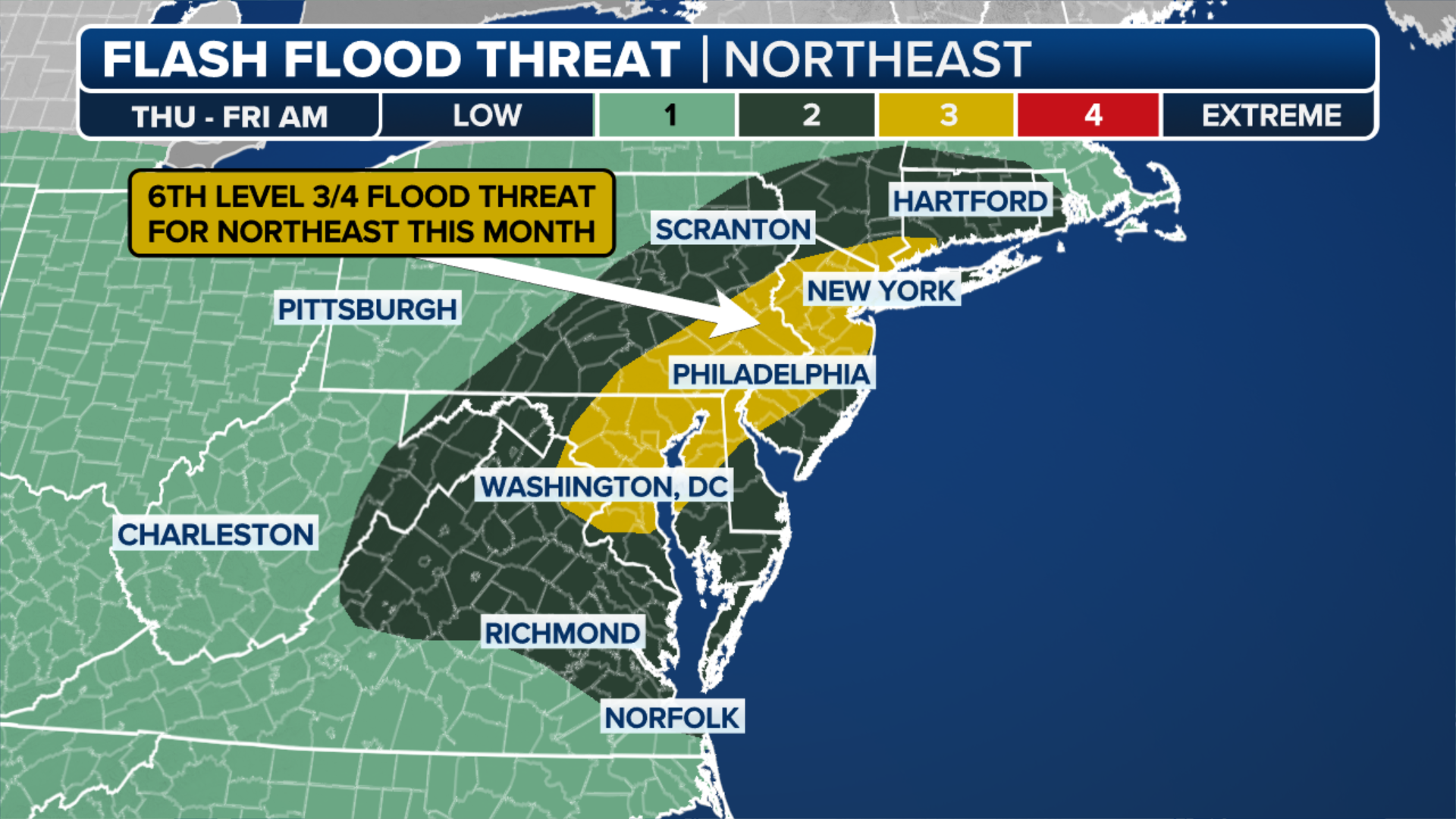
Heavy rain, severe thunderstorms moving through Northeast
FOX Weather Meteorologist Bayne Froney provides an update on the severe thunderstorms moving through the I-95 corridor and the Northeast into Thursday evening. Damaging wind gusts and tornadoes are possible from the Virginia to New England.
NEW YORK – An advancing cold front sparked widespread rain and thunderstorms along the Interstate 95 corridor in the Northeast and mid-Atlantic on Thursday, with cities like New York City, Philadelphia and Washington at risk of severe weather, including tornadoes.
Many of the thunderstorms will be more isolated or of the pop-up variety, with forecasters warning that some could reach strong to severe levels with damaging wind gusts, flooding rain and lightning.

Warning boxes are color coded as: Severe Thunderstorm Warnings in yellow, Tornado Warnings in red, Tornado Warnings with confirmed tornado in purple, Flash Flood Warnings in green, and Flash Flood Emergencies in pink.
(FOX Weather)
Computer forecast models suggest rainfall totals could climb to as much as 3 inches across portions of eastern Pennsylvania and into southwestern New England, with localized amounts possibly exceeding those figures where storms repeatedly track over the same areas.

Flooding seen on Thursday, Sept. 25, 2025 in Scranton, Pennsylvania.
(Matthew Howard via Storyful / FOX Weather)
NOAA’s Storm Prediction Center (SPC) placed tens of millions of people along the I-95 corridor from southern New England through the Northeast and into the mid-Atlantic in a Level 1 out of 5 threat on its severe thunderstorm risk scale.

(FOX Weather)
In addition, nearly 45 million people from western Massachusetts to the Delmarva Peninsula on the U.S. East Coast will be at risk of tornadoes.
This includes cities like Springfield in Massachusetts, Hartford in Connecticut, New York City, Philadelphia, Baltimore and Washington.
The National Weather Service office in Binghamton, New York, issued several Tornado Warnings on Thursday afternoon, including a confirmed Tornado Warning in Sullivan County.
A tree fell onto a home in Jeffersonville, New York as well, according to NWS spotter reports.
DOWNLOAD THE FREE FOX WEATHER APP
(FOX Weather)
Localized flooding is another concern where storms develop and repeatedly pass over the same communities, a phenomenon known as training.
Flash Flood Warnings were issued on Thursday morning for portions of Rhode Island, including the Providence area, as well as for portions of Massachusetts.

Intense rain in South Easton, Massachusetts
Video northeast of Providence shows heavy rain in South Easton, Massachusetts during some severe storms on Thursday.
Areas with poor drainage, such as urban centers, may be particularly vulnerable to standing water on roads and highways, which could create travel headaches during the evening and overnight hours.
On the other hand, many communities that have gone weeks without significant rainfall may welcome the moisture, as drought concerns have been building across parts of the East.
For most, the cold front will exit off the East Coast on Friday, bringing an end to the rainy weather.