The Perfect Storm: 31 Years Later
Probably one of the most recognizable impacts of the storm was the loss of a fishing boat named 'Andrea Gail.'

Remembering the 'Perfect Storm' in 1991 that thrashed the Atlantic Coast
It’s been 30 years since one of the fiercest storms to hit New England brought hurricane-force winds, major coastal flooding and destroyed hundreds of homes along the coast.
BOSTON – It’s been 31 years since one of the fiercest storms to hit New England brought hurricane-force winds, major coastal flooding and destroyed hundreds of homes along the coast.
The storm had a few different names: the Halloween Storm, the Unnamed Hurricane and likely what most people know it as – the Perfect Storm.
On Oct. 28, 1991, a cold front had moved through New England, allowing for a ridge of high pressure to build over eastern Canada, which ushered in typical fall weather across the northeastern U.S.
Meanwhile, a low-pressure system had formed ahead of the cold front off the coast of Nova Scotia, Canada. Also, in the Atlantic Ocean, to the west of Bermuda, was Hurricane Grace.
Other factors also allowed for such a massive storm system to form.
A building ridge of high pressure over the Great Lakes allowed for another trough of low pressure over eastern Canada to form. That combined with another deep trough of low pressure in the Rocky Mountains and allowed for the system off the coast of Canada to continue to strengthen.
On Oct. 29, the low-pressure system was still strengthening, and Hurricane Grace had moved to the northeast of Bermuda. Grace had then started to become absorbed by the cold front that moved through New England the day before.
HOW GLOUCESTER HONORS THE ANDREA GAIL AND A FISHING LEGACY SPANNING OVER 400 YEARS
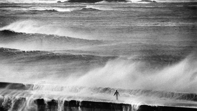
MARBLEHEAD, MA - OCTOBER 30: A view from Marblehead, MA toward Tinker's Island is pictured during the 1991 "Perfect Storm" on Oct. 30, 1991.
(Michele McDonald/The Boston Globe via Getty Images)
The system started drifting to the southwest and had nearly reached its peak intensity, with a minimum central pressure of 972 millibars, on Oct. 30. By that time, Hurricane Grace had been completely absorbed by the massive storm.
"Models did a pretty good job showing a storm up near the Canadian Maritimes was going to strengthen rapidly and actually head south, which is fairly unusual," said Joe Dellicarpini, a meteorologist with the National Weather Service in Boston.
Ships in the area were reporting winds between 50 and 60 mph, and a buoy had reported a wave height of 39 feet.
Rogue waves were also reported. A rogue wave is defined by the National Weather Service as being between 2 and 2.2 times the height of other significant waves.
In the case of the Perfect Storm, rogue waves were reported to be as high as 80 to 90 feet, and seas in the North Atlantic were as high as 100 feet.
And while the system was spinning off the coast, all the wind and wave energy was being sent right into the Massachusetts coastline.
The storm had started to weaken by Halloween, but its southerly path had brought it over a warm area of the ocean, and it's estimated that the storm acquired subtropical characteristics at that time.
The National Weather Service said it's quite unusual for a system to go from a cold-core system to a warm-core system. Typically, in New England when hurricanes and tropical storms move into the area, they become subtropical or are "nor'easters," but the opposite happened with this storm system.
That's where the "Unnamed Hurricane" came into play.
WHAT'S THE DIFFERENCE BETWEEN A NOR'EASTER AND A HURRICANE?
Gloucester, MA: the 400-year fishing legacy of America's oldest seaport
The hometown of the fishing crew lost to the
A Hurricane Hunter aircraft was sent into the storm on Nov. 1, and it found that convection in the center had increased to the point where tropical characteristics could be identified.
So, the storm did become a hurricane but was not named to avoid confusion.
The storm then began to speed off to the northeast and passed over the same area where it had originally formed just days before. It went on to make landfall in Nova Scotia as a tropical storm on Nov. 2.
TROPICAL DEPRESSION VS. TROPICAL STORM VS. HURRICANE: WHAT'S THE DIFFERENCE?
Impacts
Hurricane-force (74-plus mph) and tropical-storm-force (39-plus mph) winds were reported across New England:
Chatham, Massachusetts – 78 mph
Thatcher Island, Massachusetts – 74 mph
Marblehead, Massachusetts – 68 mph
Blue Hill Observatory, Massachusetts – 64 mph
Newport, Rhode Island – 63 mph
The high winds weren't the only destructive impact. Waves of 10 to 30 feet were reported from North Carolina to Nova Scotia. In Boston, 25-foot waves crashed onshore as high tides were already running about 4 feet above average. The tide had reached 14.1 feet above the average low tide, which was about 1 foot lower than what was reported during the Blizzard of 1978.
Dangerous surf was also reported from the Caribbean to Canada.
The loss of the Andrea Gail
Probably one of the most recognizable impacts of the storm was the loss of a fishing boat named "Andrea Gail."
The 72-foot commercial boat with a crew of six is presumed to have sunk sometime after midnight on Oct. 28, 1991, while the powerful storm was still intensifying.
Its last known reported position was about 180 miles northeast of Sable Island, and the ship's emergency beacon washed ashore on the island about a week later.
"The depiction was fairly accurate," Dellicarpini said, referencing the movie The Perfect Storm. "The last scene of the very large wave of nearly 100 feet that essentially sunk (The Andrea Gail). It’s not out of the question that there were 100-foot waves in that storm. There was a buoy in Atlantic Canada that recorded one about that height."
The story of the Andrea Gail was the subject of a book and was then turned into a movie by the same name in 2000.