Damage reported in Louisiana after possible tornado amid active week of weather along Gulf Coast
Damage was reported in Jefferson Parish, Louisiana, on Wednesday morning, after Councilman At-Large Scott Walker said a possible tornado tore across the region.

Severe thunderstorms linger along Gulf Coast
Thunderstorms are possible across parts of the Gulf Coast and parts of the Southeast on Wednesday. While the forecast has changed with a diminished threat there is still a possibility for large hail and strong winds.
NEW ORLEANS – Severe weather wreaked havoc across parts of the Gulf Coast on Wednesday morning, bringing torrential rains, damaging wind gusts and even reports of a tornado.
![This image shows damage in Jefferson Parish, Louisiana, after a possible tornado on Wednesday, May 7, 2025.]() Image 1 of 5
Image 1 of 5This image shows damage in Jefferson Parish, Louisiana, after a possible tornado on Wednesday, May 7, 2025. (Scott Walker – Jefferson Parish Councilman At-Large/Facebook)
![This image shows damage in Jefferson Parish, Louisiana, after a possible tornado on Wednesday, May 7, 2025.]() Image 2 of 5
Image 2 of 5This image shows damage in Jefferson Parish, Louisiana, after a possible tornado on Wednesday, May 7, 2025. (Scott Walker – Jefferson Parish Councilman At-Large/Facebook)
![This image shows damage in Jefferson Parish, Louisiana, after a possible tornado on Wednesday, May 7, 2025.]() Image 3 of 5
Image 3 of 5This image shows damage in Jefferson Parish, Louisiana, after a possible tornado on Wednesday, May 7, 2025. (Scott Walker – Jefferson Parish Councilman At-Large/Facebook)
![This image shows damage in Jefferson Parish, Louisiana, after a possible tornado on Wednesday, May 7, 2025.]() Image 4 of 5
Image 4 of 5This image shows damage in Jefferson Parish, Louisiana, after a possible tornado on Wednesday, May 7, 2025. (Scott Walker – Jefferson Parish Councilman At-Large/Facebook)
![This image shows damage in Jefferson Parish, Louisiana, after a possible tornado on Wednesday, May 7, 2025.]() Image 5 of 5
Image 5 of 5This image shows damage in Jefferson Parish, Louisiana, after a possible tornado on Wednesday, May 7, 2025. (Scott Walker – Jefferson Parish Councilman At-Large/Facebook)


Storm damage was reported near New Orleans in Jefferson Parish, after Councilman At-Large Scott Walker said a possible tornado tore across the region.
"There are a line of powerlines that came down," he said in a Facebook post. "It’s suspected that a small tornado came through here."
There were other scattered reports of trees and power lines down around the New Orleans area as the storm rolled through.
New Orleans' Lakefront Airport recorded a gust of 58 mph, while New Orleans International Airport measured 1.64 inches of rain – breaking a nearly 50-year-old daily rainfall record.
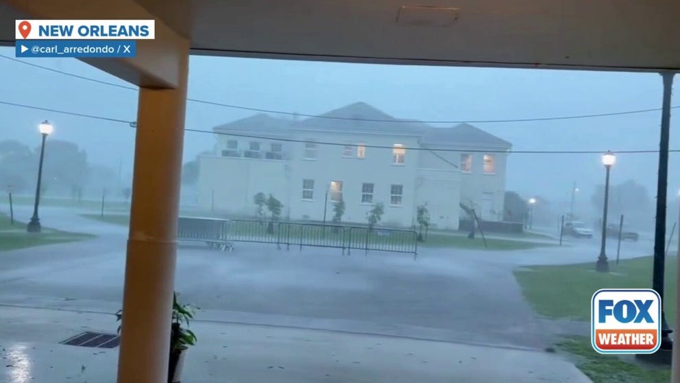
New Orleans continues to be drenched by heavy rain, as the city is under a flood watch until Thursday night.
New Orleans has broken the daily record for the most rain in one day (5/7/25), with 1.64 inches, and more is coming. The previous record was 1.33 inches of precipitation in 1976.
Extreme weather has been relentlessly pounding the region for days, leading to the death of a 10-year-old Texas girl who was swept away by floodwaters as she walked home from school. Three other people were injured when a bolt of lightning struck a home in Texas, sparking a fire.

(FOX Weather)
Torrential rain led to numerous Flash Flood Warnings in Texas and Louisiana from Tuesday night into Wednesday morning, with officials urging residents to remain vigilant and not to travel over water-covered roadways.
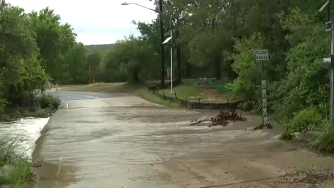
Flash flooding near Austin, TX on May 6, 2025.
(KTBC / FOX Weather)
Well over a half-foot of rain has fallen in several communities, including Lake Charles, Lafayette and New Iberia in Louisiana.
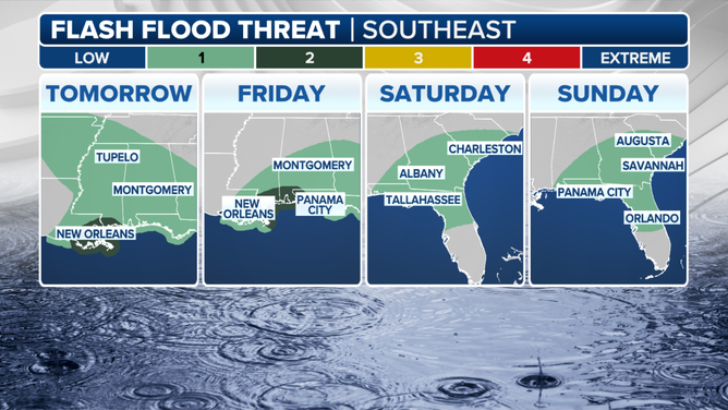
But while the severe weather threat has waned, the threat of heavy showers and flash flooding lingers into Thursday and Friday.
Multi-Day Flood Alerts for the South
Flood Watches remain in effect along the southeastern Louisiana coast, including New Orleans, and into the Gulf Coast of Mississippi and Alabama into Thursday.
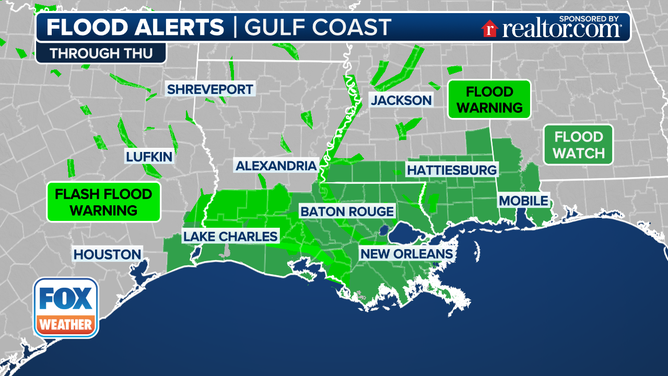
South Flood Alerts
(FOX Weather)
An additional rainfall of 1-3 inches is possible, triggering a lingering threat of flash flooding. The flooding threat shifts to the east on Friday where a Level 2 out of 4 flash flood risk lingers for the Gulf coasts of Mississippi and Alabama.