Roller-coaster weather pattern bringing record cold to the West, warm air to the East
Most of the country is dealing with weather extremes from record cold, a historic blizzard, a multiday severe weather outbreak, extremely critical fire weather conditions and warm temperatures
Springlike warmth returns to East, winterlike chill lingers in West
A pattern change is underway as springlike warmth returns to the East and a winterlike chill lingers in West.
The roller-coaster weather pattern affecting both coasts of the United States will continue Tuesday, with potentially record-cold temperatures in the West and warm air moving into the East.
Most people have heard the saying, "If you don't like the weather now, just wait five minutes," and that's been especially true over the past several days.
The West has gone from seeing record heat to record-cold temperatures and a potentially historic blizzard in the Northern Plains, while the East was dealing with cold temperatures and will now enjoy the warmer air.
HOW TO WATCH FOX WEATHER ON TV

But let's start with another severe weather outbreak that will threaten the Plains, Midwest and South through the middle of the week that's expected to bring storms capable of spawning strong tornadoes, damaging winds and large hail.
This is the fourth such outbreak in four weeks.
The system already pelted parts of Arkansas with baseball- to softball-sized hail, as well as six reports of tornadoes in Arkansas on Monday night.
HOW ARE TORNADOES RATED? THE ENHANCED FUJITA SCALE EXPLAINED
Showers and storms have continued into Tuesday but have mainly been below severe limits so far. However, that will change as we get further into Tuesday as the atmosphere becomes more and more unstable.
![]() Image 1 of 2
Image 1 of 2Cold air returns to the West this week while the East will enjoy warm temperatures. ( )
![]() Image 2 of 2
Image 2 of 2A dip in the jet stream will pull in the colder air in the West, and a ridge of high pressure will allow for the warm temperatures in the East. ( )
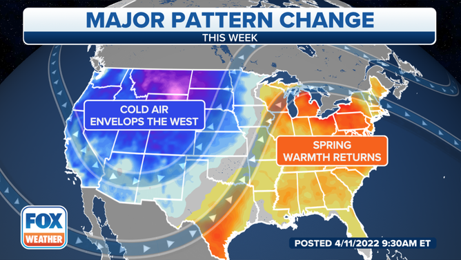
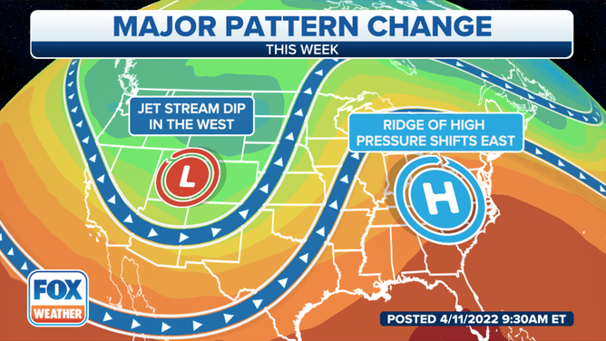
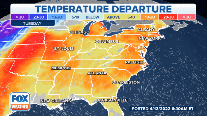
As the jet stream dips farther to the south through this week, colder temperatures are being pulled into the western U.S. from the north.
As a result, major cities across the region experiencing record-warm temperatures last week are expected to see some record-cold temperatures this week.
And that's not all. A major, late-season winter storm is expected to bring blizzard conditions to parts of the West and Plains.

Various winter weather alerts are in effect across those regions.
Blizzard Warnings extend across parts of central and eastern North Dakota and northwestern South Dakota into eastern Montana.
Winter Storm Warnings are in effect elsewhere across the Rockies and into the Pacific Northwest.

And there is the potential for some record-cold high temperatures across the region.
Deer Lodge and Helena, Montana, could see temperatures only reach 22 degrees on Tuesday.
Eureka, Nevada, and Missoula, Montana, will be just above freezing, while in Pullman, Washington, temperatures could only get into the mid-30s.
And the cold air is going to be sticking around for most of the week.
In fact, some areas of the Pacific Northwest, the Rockies and Plains could see temperatures drop to between 20 and 30 degrees below average for this time of year.
High temperatures in the East through Friday.
(FOX Weather)
It's an entirely different story in the eastern half of the United States. A ridge of high pressure will allow the springlike temperatures to return to the region after several days of winterlike temperatures.
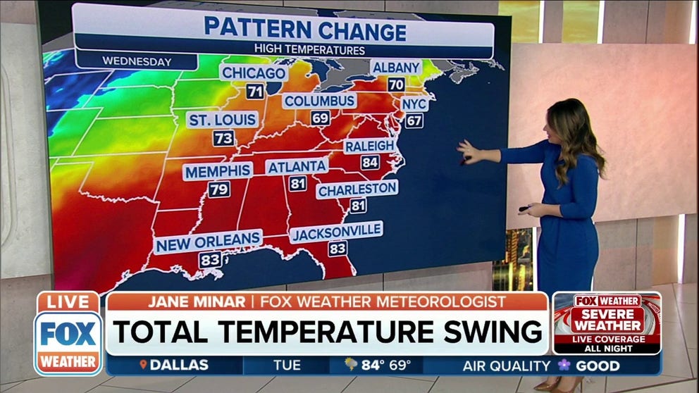
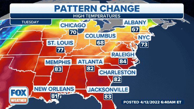
The South and Southeast will be the warmest during the week, as temperatures in some places like Memphis, Tennessee, could get into the lower to mid-80s on Tuesday.
The most extreme temperature increase will be felt in the Northeast and New England by the middle of the week.
New York City will feel the roller-coaster temperature ride. By Tuesday, the Big Apple will see temperatures around about 73 degrees before falling back to 67 degrees on Wednesday. On Thursday, however, warm temperatures return with a forecast high of 80 degrees before falling back to 65 degrees on Friday.
Temperatures will be well above average in the East this week.
(FOX Weather)
In general, temperatures will be near or above average across the eastern half of the United States this week.
However, as we head into the middle of the week, parts of the mid-Atlantic, Northeast and New England will enjoy temperatures between 15 and 20 degrees above average. Some areas of New England could see temperatures 20 to 30 degrees above average on Thursday.