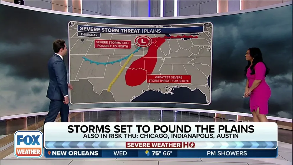
Multiday severe weather threat covers millions from Texas to Midwest for large hail, possible tornadoes
The SPC has placed nearly 18 million people in a Level 2 out of 5 risk on its severe thunderstorm risk scale on Thursday, and the threat includes cities such as Dallas-Fort Worth in Texas and Des Moines, Iowa.
Severe weather threat centered around Kansas City on Wednesday
Thunderstorms are expected to be capable of producing large hail and damaging winds on Wednesday.
KANSAS CITY, Mo. – The threat of powerful thunderstorms continues to grow across the nation’s midsection this week as millions from Texas to the Midwest and Great Lakes are bracing for yet another multiday severe weather threat.
The threat began on Tuesday in Missouri but by Thursday, the severe weather is expected grow and expand to include tens of millions of people from Dallas to Chicago.
Wednesday's severe thunderstorm threat includes central Plains, lower Missouri Valley

(FOX Weather)
Severe thunderstorm activity is expected to really get cooking on Wednesday, the FOX Forecast Center says.
Storm coverage, as well as the severe weather threat, will ramp up during the day as moisture, atmospheric energy and wind shear will be much higher.
THIS IS WHAT YOU SHOULD DO IF YOU ARE DRIVING AND THERE IS A TORNADO ON THE GROUND
There are two areas of concern on Wednesday; the first along a warm front draped across Missouri and Kansas. This first round of storms is expected to develop across northeast Kansas after 5 p.m. CT before they expand into Nebraska, Missouri and Iowa.
WATCH VS. WARNING: HERE ARE THE DIFFERENCES BETWEEN THESE WEATHER TERMS THAT COULD SAVE YOUR LIFE
![This graphic shows the large hail threat on Wednesday, March 13, 2024.]() Image 1 of 3
Image 1 of 3This graphic shows the large hail threat on Wednesday, March 13, 2024. ( )
![This graphic shows the damaging wind threat on Wednesday, March 13, 2024.]() Image 2 of 3
Image 2 of 3This graphic shows the damaging wind threat on Wednesday, March 13, 2024. ( )
![This graphic shows the tornado threat on Wednesday, March 13, 2024.]() Image 3 of 3
Image 3 of 3This graphic shows the tornado threat on Wednesday, March 13, 2024. ( )
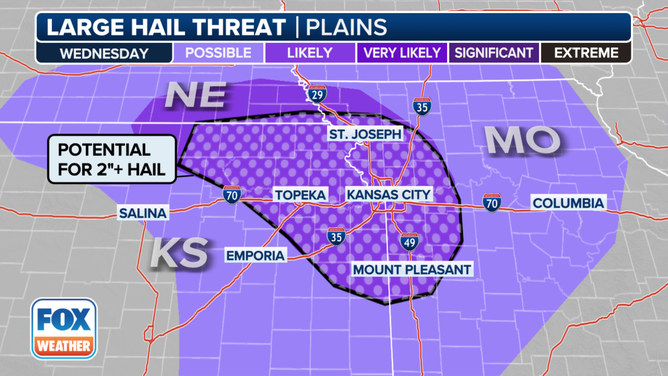


NOAA's Storm Prediction Center (SPC) has placed nearly 3 million people across the region in cities such as Kansas City in Missouri and Topeka in Kansas in a Level 2 out of 5 risk on its 5-point severe thunderstorm risk scale.
The second area of concern is from southeastern Kansas into extreme northeastern Texas, where atmospheric conditions will also support thunderstorm development. However, the FOX Forecast Center says a cap, or "lid" in the atmosphere, could block storms from forming at all in that area.
Any severe storms that do develop Wednesday are capable of large hail, damaging wind gusts over 60 mph, and a few tornadoes.
WHAT IS THE ‘CAP’ IN WEATHER? HOW THIS ATMOSPHERIC LID AFFECTS SEVERE STORMS

Watch: Tree explodes after lightning strike in Australia
Shocking video shows a bolt of lightning strike a tree, causing it to explode and narrowly missing a man.v (Video from December 2023)
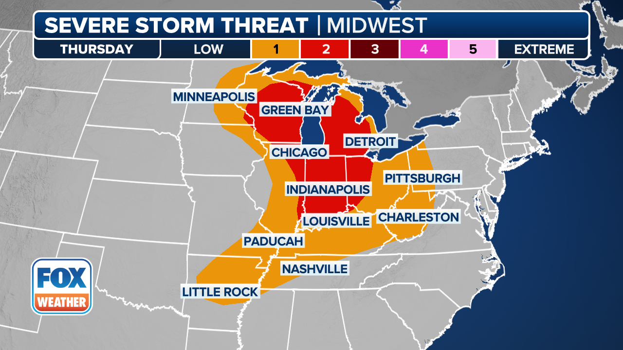
Thursday could be the main event in terms of multiday severe weather threat
(FOX Weather)
Thursday could be the day when the bulk of severe weather action will kick off, with millions of people from Texas to the Great Lakes region at risk of potentially dangerous extreme weather.
The SPC has placed nearly 18 million people in a Level 2 out of 5 risk on its severe thunderstorm risk scale Thursday, and the threat includes cities such as Dallas, Fort Worth, Arlington, Plano, Garland and Waco in Texas, as well as Springfield and Jefferson City in Missouri and Des Moines in Iowa.
The FOX Forecast Center says the day will once again focus on two main areas of potential development, with the first across southern Iowa and northern Missouri into central Illinois and the second farther south from eastern Oklahoma and Texas into Louisiana and Arkansas.
Atmospheric conditions near the area of low pressure and warm front will likely result in the development of supercell thunderstorms across northern Missouri, Illinois and southeastern Iowa.

Video captures moment straight-line winds rip roof clean off New Zealand home
Home security video recorded powerful winds ripping off a roof in Cobden, New Zealand on Monday as a line of strong thunderstorms moved through the island. (Video: Dean French via Storyful in March 2024)
Thunderstorms that develop along and south of the warm front will be capable of producing hail larger than 2 inches, wind gusts higher than 60 mph and some tornadoes.
To the south, severe thunderstorms should explode ahead of a dryline across Oklahoma and northeastern Texas - including the Dallas-Fort Worth area - during the early afternoon hours.
Any severe thunderstorm will carry a threat of large hail, damaging wind gusts over 60 mph and possible tornadoes. But the FOX Forecast Center says how thunderstorms evolve into the Thursday evening hours is still unclear.
If those storms join together and form a squall line, then the threat for damaging straight-line winds will increase, before thunderstorms weaken and fall apart overnight into Friday.

Driver caught in Tennessee tornado
Dashcam footage shows a person's car being thrown about as the Clarksville tornado overtakes their vehicle. (Video courtesy: SWNS) (Video from December 2023)
So, be sure to download the free FOX Weather app and enable notifications to be alerted to any major changes in the forecast or severe weather alerts issued in your area.