Powerful storms spawn tornado reports, damaging wind gusts as severe weather sweeps across South on Saturday
There have been no reports of injuries, but the storms that developed from the southern Plains to the Midwest and Great Lakes region did bring down numerous trees and power lines, and damage was reported, according to reports from NOAA's Storm Prediction Center.
Tornadoes, large hail reported as severe weather sweeps across South
Powerful storms swept across portions of the South on Saturday, with thunderstorms producing reports of tornadoes and high wind gusts that brought down trees and damaged homes. FOX Weather Meteorologists Nick Kosir and Bayne Frone break down the latest on Oct. 19, 2025.
LITTLE ROCK, Ark. – Tens of millions of people from Texas to Indiana faced a severe weather threat on Saturday, with numerous thunderstorms spawning damaging wind gusts, hail and even reports of tornadoes.
The extreme weather was the result of warm, humid air surging to the north from the Gulf into the Ark-La-Tex region, as well as into the Mississippi Valley and Midwest.
In addition, increasing instability in the atmosphere allowed for the development of supercell thunderstorms.

Watch: Torrential rain falls during severe thunderstorm in Arkansas
A video recorded in Ferndale, Arkansas, shows heavy rain falling as a powerful thunderstorm swept across the region on Oct. 18, 2025.
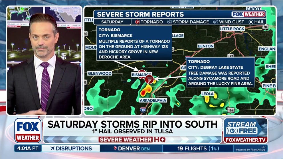
Two reported tornadoes downed trees near Bismarck, Arkansas, as limited instability and cloud cover allowed for only a few severe storms to develop across parts of the Mississippi Valley and the Southeast on Saturday.
A video recorded in Ferndale, Arkansas, on Saturday, showed torrential rain falling as the storms swept across that region in the afternoon hours.
Loud claps of thunder could also be heard as rain was falling from the sky.
DOWNLOAD THE FREE FOX WEATHER APP

Watch: Lightning illuminates sky during tornado-warned storm in Louisiana
A video recorded in Tallulah, Louisiana, shows lightning illuminating the sky as a tornado-warned storm swept across the region on Oct. 18, 2025.
The National Weather Service measured winds in Oklahoma reaching up to 60 mph, along with hail measured 1 inch in diameter outside of Tulsa, Oklahoma. Damaging winds downed trees and power lines near Shreveport, Louisiana.
Another video recorded near Tallulah, Louisiana, shows lightning illuminating the night sky as the thunderstorms raced across the area.
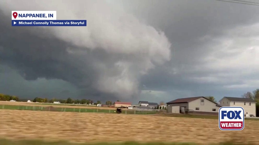
Watch: Massive wall cloud spotted over Indiana field
A video recorded in Nappanee, Indiana, shows a massive wall cloud swirling over a field as powerful thunderstorms moved over the area on Oct. 18, 2025.
And in Indiana, a video recorded in the Nappanee area showed a massive wall cloud swirling above a field as the storms moved over that region on Saturday.
Luckily, there have been no reports of injuries, but the storms that developed from the southern Plains to the Midwest and Great Lakes region did bring down numerous trees and power lines, and damage was reported, according to reports from NOAA's Storm Prediction Center.