Deadly storms leave trails of destruction in Plains, Southeast as cleanup efforts get underway
At least one person was killed during severe weather in Georgia, while another death was announced in Mississippi.

Deadly weekend storms leave Georgia reeling
Georgia residents are grappling with the aftermath of a weekend of severe and deadly storms. The extreme weather claimed at least one life in Banks County, where a man died when a tree struck his car. Across the state, hundreds of thousands were left without power. FOX 5 Atlanta reporter Marc Teichner is on the scene in Dunwoody, Georgia, with the latest.
McALESTER, Okla. – Cleanup efforts are underway in the Plains and Southeast after severe weather tore across those regions on Saturday, leaving at least two people dead.
An apparent tornado left a trail of destruction in the community of McAlester, Oklahoma, on Saturday.
![Apparent Tornado damage in McAlester, Oklahoma]() Image 1 of 7
Image 1 of 7Apparent tornado damage in McAlester, Oklahoma, on June 7, 2025. (Derrick James / @dljames0001 / X)
![Apparent Tornado damage in McAlester, Oklahoma]() Image 2 of 7
Image 2 of 7Apparent tornado damage in McAlester, Oklahoma, on June 7, 2025. (Derrick James / @dljames0001 / X)
![Apparent Tornado damage in McAlester, Oklahoma]() Image 3 of 7
Image 3 of 7Apparent tornado damage in McAlester, Oklahoma, on June 7, 2025. (Derrick James / @dljames0001 / X)
![Apparent Tornado damage in McAlester, Oklahoma]() Image 4 of 7
Image 4 of 7Apparent tornado damage in McAlester, Oklahoma, on June 7, 2025. (Derrick James / @dljames0001 / X)
![Apparent Tornado damage in McAlester, Oklahoma]() Image 5 of 7
Image 5 of 7Apparent tornado damage in McAlester, Oklahoma, on June 7, 2025. (Derrick James / @dljames0001 / X)
![Apparent Tornado damage in McAlester, Oklahoma]() Image 6 of 7
Image 6 of 7Apparent tornado damage in McAlester, Oklahoma, on June 7, 2025. (Derrick James / @dljames0001 / X)
![Apparent Tornado damage in McAlester, Oklahoma]() Image 7 of 7
Image 7 of 7Apparent tornado damage in McAlester, Oklahoma, on June 7, 2025. (Derrick James / @dljames0001 / X)


Photos from the scene showed buildings with significant damage in the town’s center, along with several trees that were snapped like twigs.
Bricks and pieces of buildings littered the streets in the downtown area, and vehicles were damaged after trees were toppled on top of them.
In Georgia, more than 200,000 power outages were reported, as well as one fatality.
Georgia Gov. Brian Kemp announced the death on X Saturday night and offered his thoughts and prayers to the victim, as well as first responders rushing to the scene to help those who were impacted by the storms.
DOWNLOAD THE FREE FOX WEATHER APP
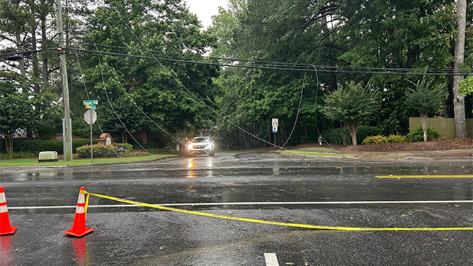
This image shows power lines that were brought down during severe weather in Roswell, Georgia, on Saturday, June 7, 2025.
(Roswell Police Department/Facebook / FOX Weather)
In Mississippi, Gov. Tate Reeves said one person was killed in Lafayette County after a tree fell onto a vehicle.
Reeves said the state remains in close contact with local emergency managers and will continue to respond as necessary.

This image shows a tree that was brought down during severe weather in Roswell, Georgia, on Saturday, June 7, 2025.
(Roswell Police Department/Facebook / FOX Weather)
Storm damage was also reported in Roswell, Georgia, on Saturday, and photos from the area showed numerous trees and power lines that were brought down during the severe thunderstorms.
Powerful storms and torrential rain also pushed through portions of Arkansas over the weekend.
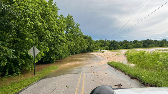
This image shows flooding in Washington County, Arkansas, on Saturday, June 7, 2025.
(Washington County Sheriff's Office/Facebook / FOX Weather)
The Washington County Sheriff’s Office shared photos showing flooding in the area, as well as a tree that was brought down during the extreme weather.
A video recorded in Cullman County, Alabama, on Saturday, showed a powerful storm rolling across that area, with loud rumbles of thunder being heard as torrential rain fell and strong winds blew through.

Watch: Severe weather rolls through Cullman County, Alabama
A video shared from Cullman County, Alabama, shows a severe thunderstorms moving through the area with strong winds and heavy rain on Saturday, June 7, 2025.