America’s heartland braces for classic severe weather outbreak early next week
April typically sees an increase in severe weather outbreaks as seasonal air masses clash over the eastern half of the country. In fact, the month is usually the second busiest for tornadoes, only outdone by May.
Multiday severe weather threat eyes the Plains, Midwest for Monday
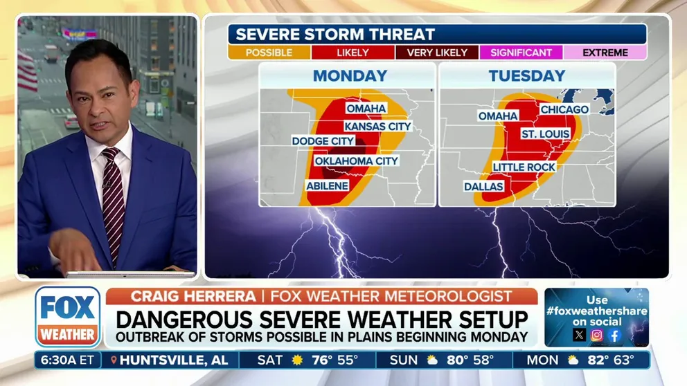
A classic spring severe weather setup is forecast to take fruition on Monday into Tuesday, threatening strong thunderstorms and possible tornadoes across a half-dozen states to kick off the workweek.
The FOX Forecast Center is tracking the evolution of a classic springtime storm system that could trigger a multi-day severe weather outbreak during the start of the workweek.
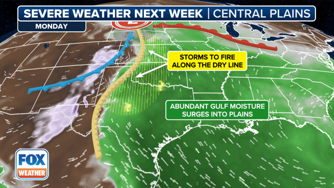
Forecast models show energy associated with a wet weather system impacting California this weekend will transition into a healthy storm over the Plains.
Meanwhile, with about three days of persistent low-level moisture coming up from the Gulf of Mexico, dew points should reach the mid-60s, and a dry line -- a boundary separating the moist Gulf air and the dry mountain air in the West -- will set up.
Monday weather forecast
(FOX Weather)
"As that dry air comes out of portions of eastern New Mexico and west Texas, bumping into all that hot, humid air, that's where we could see some of these storms fire up on Monday," said FOX Weather Meteorologist Craig Herrera.
WHAT IS A DRYLINE AND WHY ITS LOCATION IMPORTANT IN SEVERE WEATHER FORECASTING?
Thunderstorms are expected to explode along the dry line starting Monday afternoon and will likely take the form of supercells capable of all hazards, tornadoes, very large hail and damaging winds.
The Storm Prediction Center has highlighted communities in more than half a dozen states for being at an increased risk on Monday, from Texas to Iowa, with communities along the Interstate 35 corridor from North Texas through Oklahoma City into Kansas already in a level 3 out of 5 severe weather risk.

(FOX Weather)
"With the multi-day severe weather threat, you’re going to have a lot of people that are affected," meteorologist Ari Sarsalari said. "Obviously, Dallas up toward Oklahoma City, Wichita, that’s next Monday into Monday night.
The entire storm system working in a northeasterly direction.
"Then we get into Tuesday, and the whole system kind of ejects out into the Midwest and the Mississippi Valley,"Sarsalari said.
When these storms are discrete in nature, they pose the highest chance of producing a significant tornado versus a linear segment, which is more characteristic of damaging winds.
EL NINO LIKELY IN FINAL WEEKS AS WORLD AWAITS LA NINA AND POTENTIAL JOLT TO HURRICANE SEASON
Tuesday's severe weather forecast
The continued march of the storm system towards the north and east will result in the possibility of severe storms from the Great Lakes to the Lower Mississippi River Valley on Tuesday.
While the expanse of the population underneath an increased threat zone is significantly greater than on Monday, it is still unclear whether the storms will be as dynamic as during the previous day’s events.
Atmospheric ingredients may not be as prime as on Monday but will still allow for significant thunderstorm activity between Milwaukee and Little Rock, Arkansas.

(FOX Weather)
Included in the threat zone are communities such as Chicago, Dallas, and St. Louis, Missouri.
"We're also going to have a chance for some flash flooding, especially around the northern tier of this system," said Sarsalari.
Behind the storm system, much colder air is expected to filter into much of the northern tier of the country, with temperatures that will be at least five to ten degrees below average.