Severe thunderstorms knocked out power in Texas before shifting to Gulf Coast, Southeast on Sunday
In addition to torrential rain and skies full of lightning, wind gusts reached 45-60 mph across the Houston metro area, with a gust of 59 mph measured in downtown Houston and a 64-mph gust in Hempstead, according to the National Weather Service. After battering Texas, the line of severe weather moved farther east to the Gulf Coast states on Sunday.
Tornado Watch in place for parts of Gulf Coast on Sunday
A Level 2 out of 5 threat of severe weather is possible across parts of the Gulf Coast on Sunday, which includes the potential for tornadoes. A Tornado Watch is in place for southeast Louisiana, including New Orleans, and southern Mississippi.
HOUSTON – The weekend got off to a rocky start in parts of southeastern Texas as a line of severe thunderstorms swept through early Saturday morning, knocking out power to hundreds of thousands of customers.
In addition to torrential rain and skies full of lightning, wind gusts reached 45-60 mph across the Houston metro area, with a gust of 59 mph measured in downtown Houston and a 64-mph gust in Hempstead, according to the National Weather Service.

Warning boxes are color coded as: Severe Thunderstorm Warnings in yellow, Tornado Warnings in red, Tornado Warnings with confirmed tornado in purple, Flash Flood Warnings in green, and Flash Flood Emergencies in pink.
(FOX Weather)
About 260,000 were without power as dawn broke on Saturday across southeastern Texas, according to PowerOutage.com, with over 150,000 of those outages in the Houston area. By Sunday morning, most customers were restored, with around 25,000 still without power.
Earlier in the night on Saturday, severe thunderstorms blasted the Dallas-Fort Worth Metroplex area with gusts as high as 67 mph in the Fort Worth area.

Tree damage in Fort Worth, Texas on Oct. 25, 2025.
(@JustinWHill / X)
Radar indicated a possible tornado south of Fort Worth on Friday evening. The NWS Fort Worth office sent a storm survey team to investigate whether a tornado touched down and ruled that the observed damage "was sporadic" and "more consistent with straight-line winds up to 85 mph."
According to the NWS survey, the team identified a number of locations that suffered from tree and light structural damage across central and south-central Fort Worth. Damage included snapped tree branches, damaged power lines, knocked over light poles and partially damaged roofs.
The survey team concluded that the damage was most likely caused by an intense line of thunderstorm winds, not a tornado.
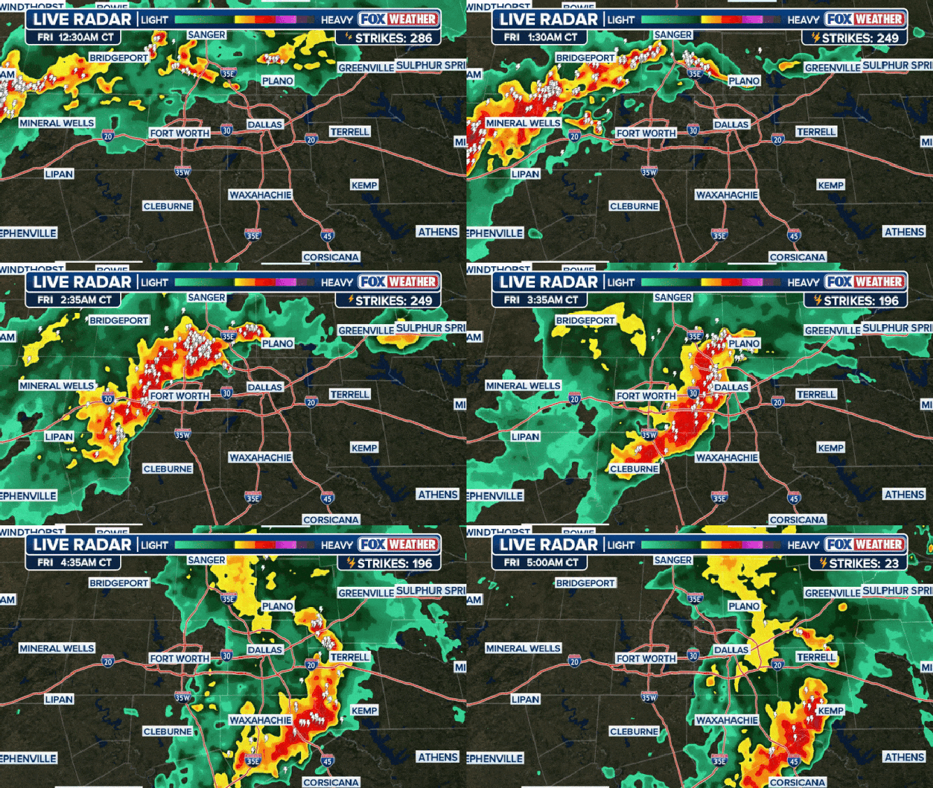
It was just the next wave of severe weather that also rolled through the Metroplex Friday morning. A wave of thunderstorms brought hundreds of lightning strikes to Dallas and its northern suburbs.
Local fire departments reported six houses caught fire in the predawn hours Friday in Dallas and Denton counties as the storms rolled through.

Dallas-Fort Worth Metroplex radar loop on the morning of Oct. 24, 2025.
(FOX Weather)
While the causes of the fires were still under investigation, fire officials did confirm lightning as the cause of some of the fires.
Overall through the day, storms dropped 3.10 inches of rain at Dallas-Fort Worth International Airport, setting a daily rainfall record and notching its third-wettest October day in 25 years.
Severe storms shift to Gulf Coast on Sunday
After battering Texas, the line of severe weather moved farther east to the Gulf Coast states on Sunday.
Heavy rain and strong winds lash throughout parts of Mississippi
The roofs of structures in parts of Mississippi have been damaged amid a tornado warning issued today (10/26/25).
Louisiana through the Florida Panhandle could see damaging winds with a possible tornado. The greatest severe weather threat area encompasses New Orleans to Mobile, Alabama.

(FOX Weather)
A Tornado Watch is in effect for parts of southeast Louisiana, southern Mississippi and southwest Alabama through Sunday afternoon. The watch includes New Orleans and Biloxi.

(FOX Weather)
Rain is forecast to continue for the South through Tuesday. A flash flood threat exists for this region, with widespread rain totals between 1 and 3 inches.
By Monday, the storms will shift into the Southeast, eventually making it up to the Carolinas by Tuesday.

