FOX Weather Storm Tracker cameras capture video of intense tornado sweeping through Plains
Wednesday’s strongest storms impacted parts of Kansas and Missouri.
Tornado caught on video by FOX Weather Storm Tracker
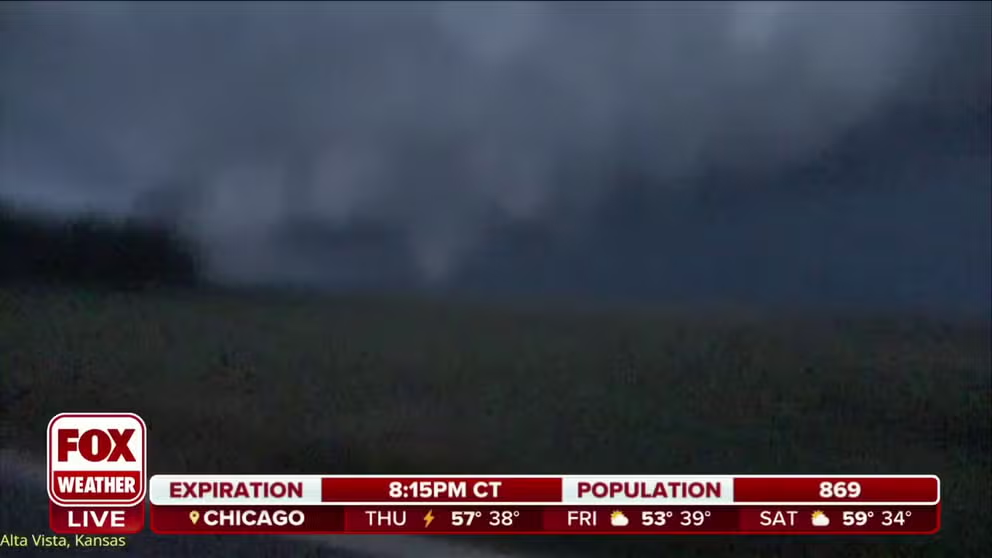
A significant tornado was spotted outside of the town of Alta Vista in Northeast Kansas on Wednesday evening.
KANSAS CITY, Mo. – The second day of severe weather across the Plains and the Midwest produced at least one significant tornado in Kansas and led to upwards of softball-sized hail.
NOAA's Storm Prediction Center highlighted communities in two states for being at an enhanced risk or a Level 3 out of 5 for hail, damaging winds and tornadoes, and it appears the forecast panned out with numerous Tornado and Severe Thunderstorm warnings issued by local National Weather Service offices.
FOX Weather Storm Trackers were in the right place at the right time and captured video of a supercell producing a large tornado outside of the town of Alta Vista in Northeast Kansas.
The town is less than an hour's drive outside of Topeka in Wabaunsee County.
Local authorities did not relay information about any widespread damage after the twister rolled through, but PowerOutage.us reported at least 200 customers in the rural county lost electricity.
"Usually the first storm that gets up and going kind of shows you how the day is going to go. And it's in that time frame that the low level jet really starts ripping through here…The tornado threat has increased a little bit judging by this first storm that got going here - still looking for mainly a hail threat tonight," said FOX Weather Storm Tracker Corey Gerken.
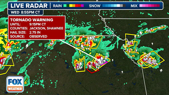
Doppler radar showing tornadic warned storm in Kansas
(FOX Weather)
The NWS office that covers the Topeka area was tasked with surveying damage and determined that two EF-2 tornadoes impacted the region, but damage was limited to trees and outbuildings.
In other counties, it was the hail that was the biggest story, with more than 100 reports across several states.
During the height of the activity, meteorologists warned some communities in the Kansas City metro to find shelter and stay away from windows.
![Large hail in Shawnee, Kansas]() Image 1 of 4
Image 1 of 4Large hail in Shawnee, Kansas (Veronika Whitaker Ray)
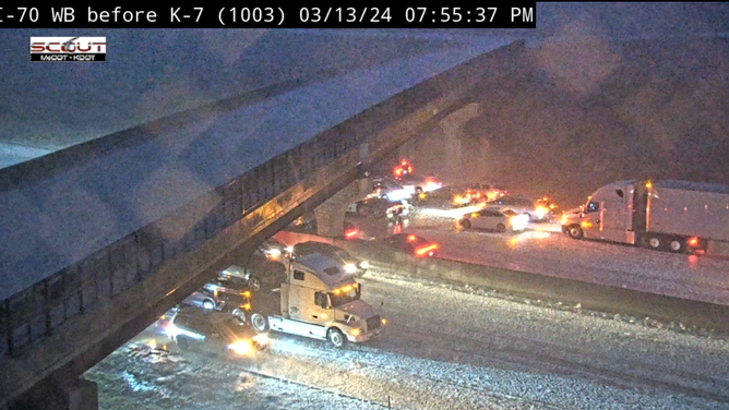
![Traffic halted on Interstate 70 in western Missouri due to hail.]() Image 2 of 4
Image 2 of 4Traffic halted on Interstate 70 in western Missouri due to hail. (MODOT)
![FOX Weather Hail Tracker showing hail cores.]() Image 3 of 4
Image 3 of 4FOX Weather Hail Tracker showing hail cores. ( )
![Tornado caught on video by FOX Weather Storm Tracker]() Image 4 of 4
Image 4 of 4Tornado caught on video by FOX Weather Storm Tracker ( )

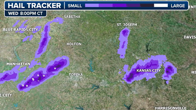

The largest sized hail was reported in the southwest Kansas City metro. Storm spotters relayed reports of hail larger than baseballs.
The hail was significant enough that traffic piled up on Interstate 70 near the Kansas-Missouri state line.
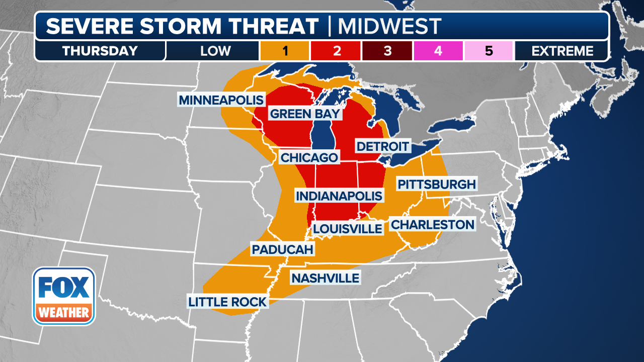
Severe weather threat expands Thursday
The severe weather threat is not over as Thursday's focus will shift south and east from where storms impacted communities on Wednesday.
The first will span from southern Iowa and northern Missouri into central Illinois, while the other will be located farther south from eastern Oklahoma and East Texas into Louisiana and
"We actually have a Level 3 out of 5," Merwin said. "The fact that the Storm Prediction Center has triggered this for Thursday ahead of time says something."
THIS IS WHAT YOU SHOULD DO IF YOU ARE DRIVING AND THERE IS A TORNADO ON THE GROUND
(FOX Weather)
The setup will be very similar to that of Wednesday. Conditions near the surface low-pressure system and the warm front will likely result in an arc of supercells across northern Missouri, Illinois and southeastern Iowa.
If you live south of the front in the warm air, you could see storms that produce tornadoes, strong wind gusts and hail larger than 2 inches. However, any storm that moves north of the front will likely only produce hail.
To the south, storms should explode ahead of a dryline across Oklahoma and northeastern Texas starting early in the afternoon, the FOX Forecast Center said.
With temperatures expected to remain around 80 degrees and dew points in the 60s, ample atmospheric energy will be available. This will combine with moderate wind shear to create supercells capable of producing all severe weather hazards.
It remains a bit uncertain how the initial supercells will develop throughout the evening, the FOX Forecast Center said. If they combine to form a squall line, the risk of destructive straight-line winds will rise before the storms weaken overnight.
Friday and beyond
The threat of strong to severe thunderstorms will likely continue into Friday from East Texas into the Southeast as the main front gets caught up along the South.
A string of wet days is becoming likely through the weekend for locations that don't need any additional rain. Jackson, Mississippi, is currently experiencing its fourth-wettest start to the year and is again in the bull's-eye for heavy rain.

(FOX Weather)
Multiple days of heavy rain will lead to a swath of 3-plus inches across Louisiana, Mississippi and Alabama, with possibly even higher amounts.
Be sure to download the free FOX Weather app and enable notifications to be alerted to any major changes in the forecast or severe weather alerts issued in your area.