A look at a phenomenon that could derail an active hurricane season
NOAA says more than 180 million tons of dust leave the African continent annually, and the extent of the dust plume is highly dependent on how much rain falls across northern Africa.
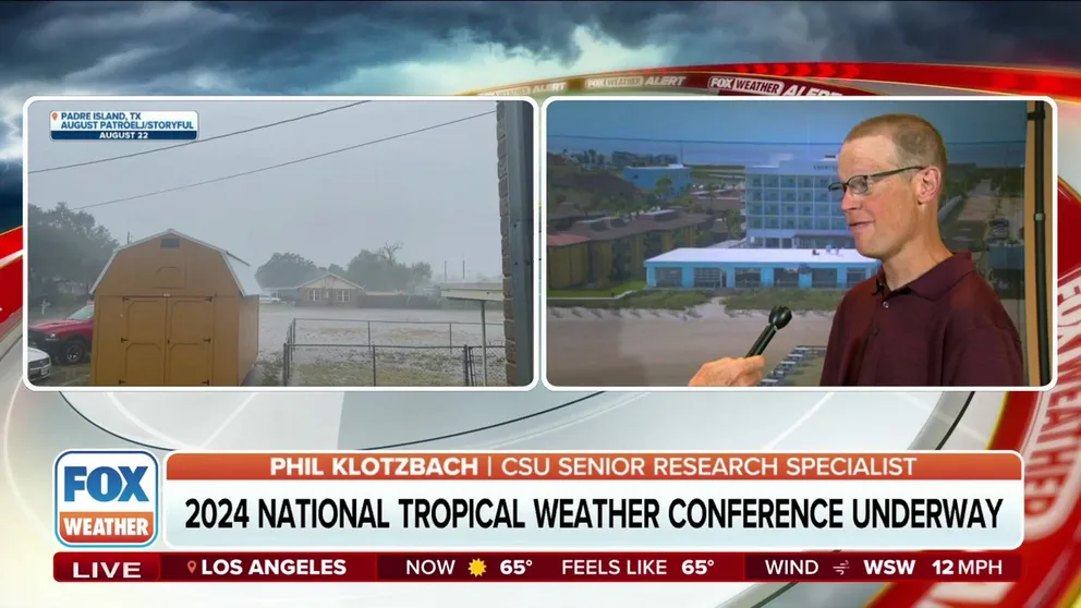
CSU hurricane expert: All signs point to active hurricane season
On the eve of Colorado State University's release of its 2024 hurricane outlook, Doctor Phil Klotzbach joined FOX Weather to discuss the upcoming season.
While forecasters are predicting a busy 2024 hurricane season, exceptional rounds of Saharan dust that have plagued Europe could act as a wild card as the atmosphere transitions into summer.
Every year, NOAA estimates more than 180 million tons of dust leave the African continent, but the extremely dry air also cuts down on thunderstorm activity and tropical cyclone formation.
Over the last several months, major cities across Europe such as Rome, Paris, Athens and Kyiv have reported reduced visibilities and poor air quality as plumes have traveled northward from the African deserts.
"While it is not unusual for Saharan dust plumes to reach Europe, there has been an increase in the intensity and frequency of such episodes in recent years, which could be potentially attributed to changes in atmospheric circulation patterns," Mark Parrington, a scientist at Europe's Copernicus Atmosphere Monitoring Service, said in a statement.
![Greece Saharan dust]() Image 1 of 4
Image 1 of 4A man walks along a footpath on a hill in Athens, shrouded by dust from the Saharan desert on March 31 , 2022. Athens is shrouded in haze, as south warm winds have carried waves of dust from the African continent across the Mediterranean. Medics have adviced people with asthma and raspitatory diseases to stay home. (Photo by Louisa GOULIAMAKI / AFP) (Photo by LOUISA GOULIAMAKI/AFP via Getty Images) ( LOUISA GOULIAMAKI/AFP via Getty Images)
![Dust Italy]() Image 2 of 4
Image 2 of 4STADIO OLIMPICO GRANDE TORINO, TURIN, ITALY - 2024/03/30: A general view of Olimpico Grande Torino stadium is seen as the sky looks yellow due to the dust from the Sahara desert carried by the Sirocco wind prior to the Serie A football match between Torino FC and AC Monza. Torino FC won 1-0 over AC Monza. (Nicolò Campo/LightRocket via Getty Images)
![Saharan dust over Ukraine]() Image 3 of 4
Image 3 of 4Air pollution from Saharan dust shrouds buildings in Kyiv, Ukraine, on Tuesday, April 2, 2024. Dust caused by sand from the Sahara has increased the concentration of particles in the air in the Ukrainian capital. (Andrew Kravchenko/Bloomberg via Getty Images)
![Rain brings Saharan dust]() Image 4 of 4
Image 4 of 408 April 2024, Cologne: Saharan dust covers the surface of a car after a shower. Photo: Henning Kaiser/dpa (Photo by Henning Kaiser/picture alliance via Getty Images) (Photo by Henning Kaiser/picture alliance via Getty Images)


5 THINGS TO KNOW ABOUT THE SAHARAN DUST PLUME
As wind patterns change during the summer months, instead of the dry air layer taking a northerly path, more Saharan dust will be shunted westward, which is home to the main development region for tropical cyclone activity in the Atlantic basin.
What forecast models can’t determine at this point is if the intensity of the plumes will continue or if they’ll follow previous years’ waxing and waning patterns.
Certainly, a feature that forecasters will study is whether the El Niño had any role in the increased amounts of dust across Europe.
El Niños are known to produce drier conditions across the heart of Africa, while rounds of precipitation are typically experienced in coastal regions along the Indian Ocean.
With the Pacific now largely exhibiting a neutral status and even a chance of a La Niña by year’s end, weather patterns are destined to flip, which could change any influence the El Niño-Southern Oscillation (ENSO) has over the proliferation of the dust.
Climate studies argue against there being any noticeable correlation between the ENSO and the plumes, since dust has generally been on the uptick for years.
Researchers from Spain have noted a sharp increase in Saharan dust intrusions when compared to the early 2000s.
"Since 2020, we are monitoring increases on the temperature of the Mediterranean and a persistent drought in the Maghreb. These surface conditions are contributing to the occurrence of these exceptional winter Saharan events towards Europe in the last years," Sara Basart, a scientist at the World Meteorological Organization and study author, stated after the publication.
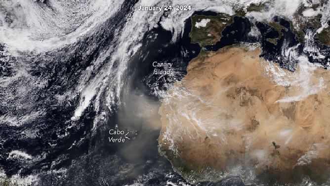
Satellite animation of dust from January 24 - 28, 2024.
(NASA)
HURRICANE SEASON 2024: HERE’S WHAT TO LOOK FOR IN THE TROPICS THIS YEAR
What to watch for during the hurricane season
Significant plumes of dust and dry air are common in the Atlantic during the first two and a half months of the hurricane season.
The prohibitive nature of the Saharan Air Layer (SAL) is one of many reasons why tropical development zones in June, July and the early days of August are limited to the western basin.
While dry air can dominate the atmosphere in the eastern Atlantic during the early season, the Gulf of Mexico, Caribbean and southwest Atlantic are usually open for business.
If levels of SAL maintain a steadiness after about Aug. 20, then there would be significant ramifications to both the amount of cyclones and their overall strength.
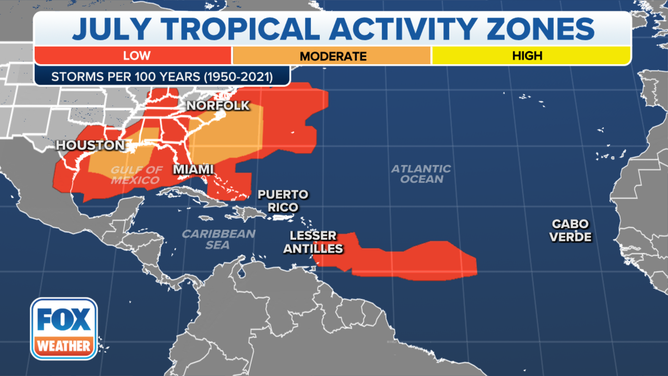
This map shows where tropical cyclone activity tends to occur during July. The data are shown as the combined number of tropical depressions, tropical storms and hurricanes whose centers pass within 125 miles of a point on the map during a 100-year period. The analysis is based on data from the 72-year period from 1950 to 2021 but normalized to 100 years.
(FOX Weather)
Meteorologists widely accept late-August as the start of the uptick in activity in the basin, including in what is known as the main development region.
Every Aug. 20, William Gray, the late hurricane researcher at Colorado State University, would ring a bell signifying the ramp-up of activity before the peak of the season.
If negative factors exist when forecasters expected a positive environment for cyclones, the year will not live up to pre-season expectations.
During its April hurricane outlook, a team of researchers at CSU said they expect 23 named storms to form in 2024, with 11 that could reach hurricane status. Five of the 11 hurricanes are expected to reach major hurricane status with winds of at least 115 mph.
An average season across the basin only yields 14 named storms, seven hurricanes and three majors, meaning forecasters expect pristine conditions to be prevalent across the basin for a large chunk of the season.
If drier air is in place longer than is typical over the basin, outlooks calling for a hyperactive season would need to be toned downwards, but again, without reliable model data, the impacts of SAL likely won’t be known until the season is well underway.
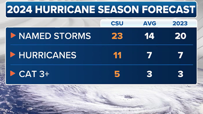
2024 CSU hurricane outlook compared to an average season
(FOX Weather)
"As we saw two years ago, in 2022, when the weather conditions suddenly became hostile to the development of tropical systems, it shut off most of July and August. We ended up, of course, with Hurricane Ian and a very busy September and October, but the overall numbers weren’t right," FOX Weather Hurricane Specialist Bryan Norcross previously stated during an interview about the coming season. "So, the odds are extremely high that it’s going to be an active hurricane season. But, you know, will the numbers work out? I don’t know. You can have local weather effects that essentially block storm development for some reason or another."
In addition to the dust’s impact on precipitation and hurricane formation, plumes can make it all the way across the Atlantic, producing colorful sunrises and sunsets in Florida and other nearby states.