CSU hurricane outlook shows which states could be threatened in 2024
Dr. Phil Klotzbach, a senior research scientist at Colorado State University, is expecting 23 named storms to form in 2024, with 11 that could reach hurricane status, with winds of at least 75 mph. Nearly half of all could become major cyclones with winds of at least 115 mph.
Bryan Norcross: 'Odds favor extremely active hurricane season'
FOX Weather Hurricane Specialist Bryan Norcross gives his analysis on Colorado State University's 2024 hurricane season outlook.
Colorado State University’s first outlook for the 2024 hurricane season shows what could be a busy time period for forecasters, with around 23 named storms expected to form in the Atlantic basin and nearly half becoming hurricanes.
Dr. Phil Klotzbach, a senior research scientist at CSU, said his team has more confidence in this year’s outlook than previous April releases because of the state of the atmosphere and other favorable signals.
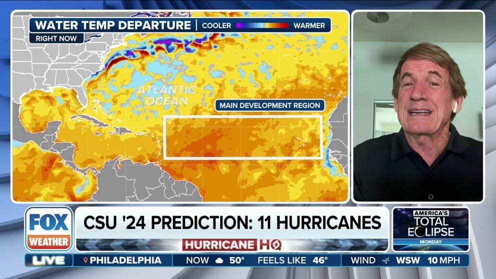
Within the report, the team highlighted states and regions where the chance of a cyclone passing through is either above or below climatological odds.
The outlook put the odds of a major hurricane making landfall along the U.S. coastline at 62%, while the odds for a strike in the Caribbean were the highest at 66%.
Within the Lower 48, CSU said it was nearly a guarantee that at least one cyclone will pass within 50 miles of Florida during the season, with states in New England having the least probability.
Chances across all coastal states are about 10-20% higher than what is considered to be average, with Alabama seeing the highest increase.
2024 ATLANTIC HURRICANE SEASON COULD BE AMONG MOST ACTIVE ON RECORD, EXPERTS PREDICT
Researchers said landfall probabilities are linked to the expected Accumulated Cyclone Energy, which is commonly referred to as the ACE index.
The ACE value of a tropical cyclone is calculated by its maximum sustained six-hour wind speed and the storm’s longevity.
A cyclone that is around longer with high sustained winds will have a higher ACE value than one that quickly forms and falls apart.
During the 2024 season, researchers expect the Atlantic Ocean, Gulf of Mexico and Caribbean to produce an ACE value of 210, which is 170% of what an average season would produce.
Nearly 60% of the total ACE is expected to occur west of 60°W longitude, which is where nearly the entire population of people impacted by tropical storms and hurricanes in the basin exist.
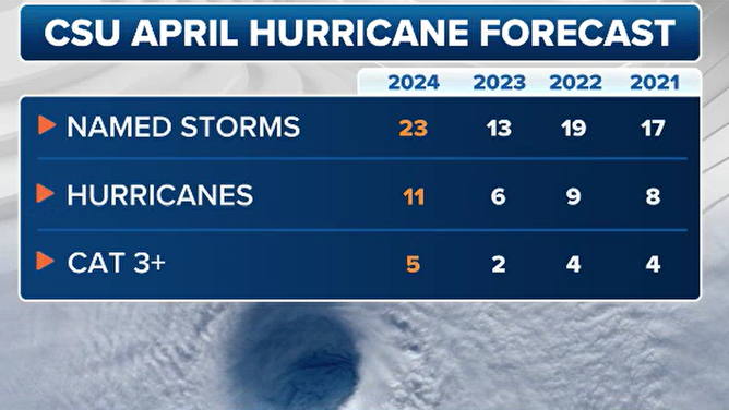
CSU April hurricane forecasts
(FOX Weather)
"When you have an El Niño like we did last year, in general, the storm pattern is to take the storms up before they get to the islands, and before they get to the U.S.," said FOX Weather Hurricane Specialist Bryan Norcross. "Now that we’ve switched to La Niña this year, there’s colder water in the Pacific that tends to create a pattern that lets storms come a little farther west and also gets them more likely into the Caribbean. And of course, once the storm gets in the Caribbean, sometimes they get up into the Gulf, and affect Florida and so forth."
A reduced or heightened probability does not guarantee or preclude an area from a direct strike.
In 2023, the probability of the Florida Panhandle being impacted by a major storm was only 28%, but it was the only region of the country impacted by a significant cyclone.
"The bottom line is, if you live in a hurricane zone, you can’t turn off your brain to hurricanes. And this is the time of year to be sure that you’re doing the big things of figuring out how you’re going to protect your house," said Norcross.