Drenching storms ride along 'ring of fire' sparking days of severe weather
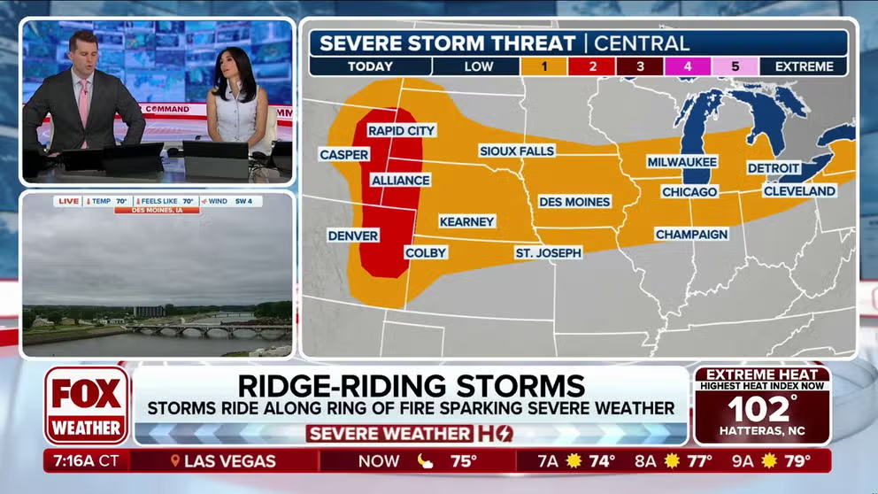
A Level 2 out of 5 severe storm risk exists Tuesday for portions of the Plains and Rockies as another disturbance rides along the northern periphery of the ridge. This will pose mainly a large hail (larger than 2 inches) threat, along with damaging winds. A few tornadoes are also possible, especially in Wyoming, South Dakota and parts of Colorado.
Ridge-riding storms along 'ring of fire' to spark severe threat in central Plains
A strong ridge of high pressure has settled across the East, bringing record-breaking heat through the first half of this week. Meanwhile, storms tracking around the periphery of this ridge or ring of fire will pose risk of flash flooding and severe weather from the Plains into the Midwest.
A "ring of fire" weather pattern is intensifying storm threats across the Plains and Midwest, bringing with it a significant increase in tropical moisture that elevates the risk of widespread flooding.
A cold front stretching from Wisconsin down toward western Kansas is carrying very warm and humid air sitting just ahead of it, the FOX Forecast Center said.

Stormy skies hover over Colorado
FOX Weather Storm Tracker Mark Sudduth was out chasing severe storms near Denver and Bennett, Colorado Tuesday afternoon.
This combination of heat, moisture and a weak disturbance aloft again triggered numerous thunderstorms on Tuesday across the northern portion of the large ridge of high pressure sitting across the East.

Warning boxes are color coded as: Severe Thunderstorm Warnings in yellow, Tornado Warnings in red, Tornado Warnings with confirmed tornado in purple, Flash Flood Warnings in green, and Flash Flood Emergencies in pink.
(FOX Weather)
A Level 2 out of 5 severe storm risk remain in effect Tuesday for portions of the Plains and Rockies as another disturbance rides along the northern periphery of the ridge. This will pose mainly a large hail (larger than 2 inches) threat, along with damaging winds. A few tornadoes are also possible, especially in Wyoming, South Dakota and parts of Colorado.

(FOX Weather)
Scattered storms will also be possible across the central Plains into the Great Lakes and northern New England.
The FOX Forecast Center said storms will likely form in clusters, which could merge quickly and enhance the wind threat as they move east.
Farther south, in the Tennessee Valley and mid-South, scattered storms are also expected but with a lower chance of becoming severe. A few isolated storms may also pop up along the Appalachians under the influence of high pressure and intense daytime heating.
Repeated rounds of heavy rain and thunderstorms will be possible into early next week for millions of people in the Upper Midwest. Several inches of rain could fall, raising the risk of flash flooding.
A widespread 3-5 inches of rain is likely for the northern Plains and Upper Midwest. For this reason, NOAA's Weather Prediction Center has highlighted these areas in its excessive rainfall outlook each day through Thursday.
This pattern will begin to break down by mid- to late-week as the ridge weakens and shifts east.
This breakdown in the pattern will also reintroduce a northeasterly flow across portions of the Southeast. This will increase the storm risk for areas along the East Coast by Wednesday afternoon.