Rare June rain for California persists through workweek as Northwest sees flooding potential
An Omega block has anchored unsettled weather over the West Coast through much of May and early June, setting California up for rare June rain.

Thunderstorms could pack a punch in California on Wednesday
June is typically the start of California’s dry season, but that’s not the case this week as nearly a half-inch of rain could fall through the end of the week. And while that doesn’t seem like a lot, many areas of the Golden State average little rainfall throughout the month of June.
June is typically the start of California’s dry season, but parts of the Golden State could pick up an inch or two of rain this week.
A dip in the jet stream is allowing an upper-level low to spin across the state, which will allow showers and thunderstorms to pop up during the afternoon and evening hours.

(FOX Weather)
As the low pushes east, so will the severe weather threat. For Thursday, only eastern and northern mountains in California will see the pop-up storms. Much of the state will keep the gray clouds and cool temperatures though.

(FOX Weather)
Severe weather possible in the Northwest Thursday
The severe weather threat in the West pushes into Washington, Idaho and southwestern Montana.
The main threats from thunderstorms that develop will be dangerous lightning, gusty winds and large hail.
238-MPH JET STREAM SHAVES AN HOUR OFF CROSS-COUNTRY FLIGHTS TO EAST COAST

(FOX Weather)
Highest rain totals expected in higher elevations
The higher elevations in northern parts of California will likely see the highest rain totals through the end of the workweek. Many areas could pick up 1 to 2 inches of rainfall, with some locally higher amounts.
The farther south you go, the lower the rain totals will be. Those totals will likely be less than a half-inch, but some 1-inch rain totals in parts of the Sierra Nevada aren’t out of the question.
HOW MUCH IS LITERALLY A ‘BOATLOAD OF RAIN’?

(FOX Weather)
Second round for weekend
The upper-level low will slowly drift inland through late week. That will push thunderstorms eastward each day. Thursday and Friday will be California's driest days as storms move across Nevada. With the weekend, however, comes another upper-level low that will drop down the West Coast and bring another chance of storms.
Omega block
If you are wondering why so many rare rain chances are happening in June, blame it on an Omega block. A large and very stubborn high-pressure center has set up over the center of the country. At the same time, the jet stream has dipped southward over the West and East coasts. This has resulted in rounds of storms as upper-level lows ride along the jet stream.
The configuration of the jet stream looks like the Greek letter Omega (Ω), so meteorologists call this an Omega block.
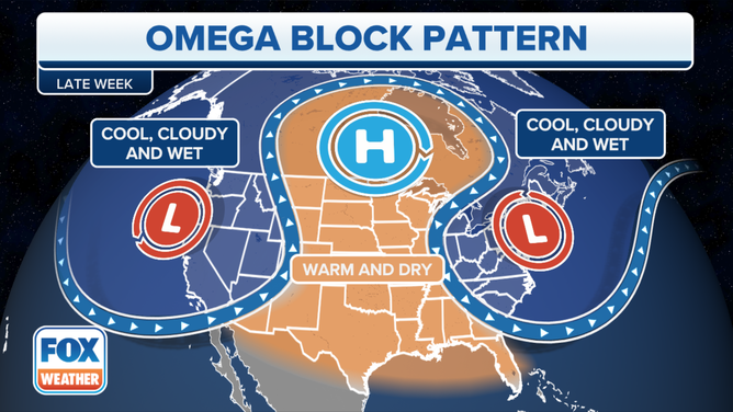
The Omega block is a persistent weather pattern.
(FOX Weather)
Omega blocks are usually large, which means they are one of the more stubborn blocks to break down. This can create concerns for flooding where the wet weather persists and drought worries where the dry weather happens.