What record-setting ocean temps mean for sea life and 2024 hurricane season
Changes in ocean temperatures can impact everything from the status of coral reefs to the favorability of hurricane formations. During positive phases of the El Niño and the Southern Oscillation (ENSO), the Pacific Ocean has water temperatures that are above average.
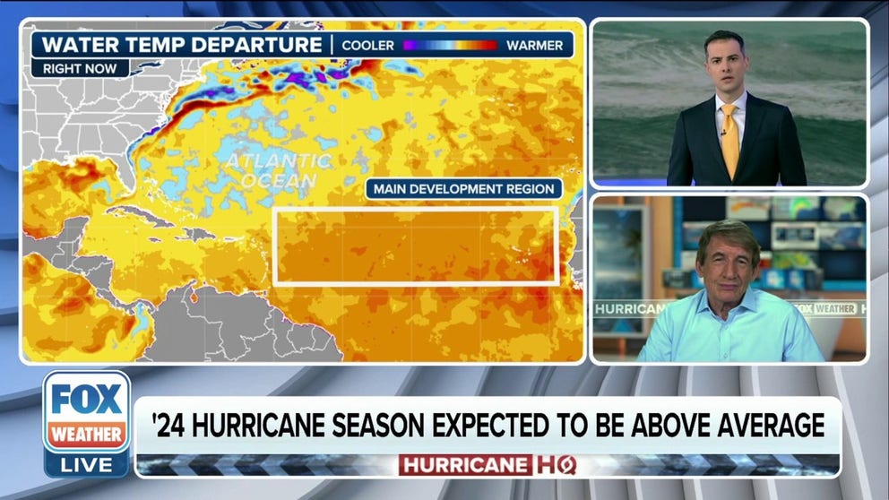
2024 Hurricane season activity expected to be above average
The combination of a weakening El Nino and warm water temperatures could be ingredients for an active hurricane season in the Atlantic basin.
Even though the 2023-24 El Niño was not historic, water temperatures across many of the Earth’s vast oceans continue to set records, which has widespread implications.
During the positive phases of the El Niño and the Southern Oscillation, or what is commonly referred to as the ENSO, the world’s largest ocean – the Pacific – usually has water temperatures above average. During the last several months, however, all of the oceans have been in record territory.
According to observational data from the Climate Change Institute at the University of Maine, global water temperatures are running about 1.44 degrees Fahrenheit above the mean, with the North Atlantic Ocean closer to around a whole 2 degrees F above average.
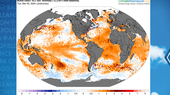
Global sea surface temperatures as of March 5, 2024.
(Climate Change Institute at the University of Maine / FOX Weather)
Anomalies, or the temperatures above or below normal, have been greater, but it is the extent of how long warm water has existed that has scientists concerned.
"Ocean surface temperatures in the equatorial Pacific clearly reflect El Niño. But sea surface temperatures in other parts of the globe have been persistently and unusually high for the past 10 months," Celeste Saulo, the World Meteorological Organization’s Secretary-General, said in a statement. "The January 2024 sea-surface temperature was by far the highest on record for January. This is worrying and cannot be explained by El Niño alone."
Water temperatures in the North Atlantic have been in record territory for more than a year, and the last time the world’s basins were collectively cooler than average was in 2011.
HURRICANE SEASON 2024: HERE’S WHAT TO LOOK FOR IN THE TROPICS THIS YEAR
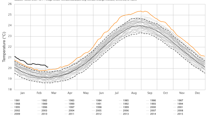
North Atlantic Sea surface temperatures as of early March 2024.
(Climate Change Institute at the University of Maine / FOX Weather)
Impacts from warmer oceans
When water is warmed, it expands. NASA estimates that one-third to one-half of global sea rise is because of the warmer oceans.
This can lead to coral bleaching, melting of ice sheets, fluctuations in the intensity of storm systems and changes to ecosystems.
Rapidly changing water temperatures have been documented to put stress on coral reefs, causing mass bleaching and disease.
In 2023, NOAA estimated that less than 22% of about 1,500 staghorn coral survived the warm water around the Florida coastline.
Just a 2-degree change in temperatures can cause coral to lose the beneficial algae.
According to marine biologists, bleached coral is not dead. However, it leads to the ecosystem being less resistant to disease and storms.
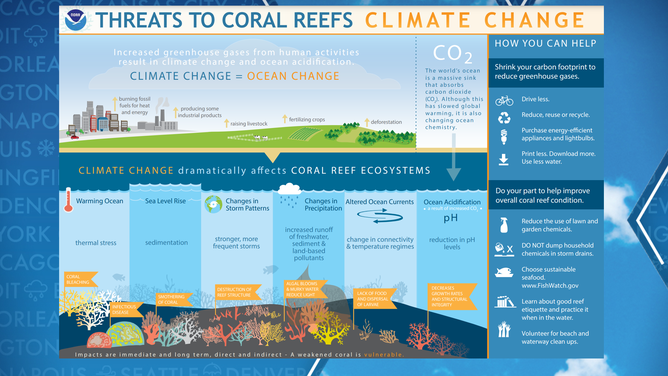
A graphic explaining how climate change impacts coral reefs.
(NOAA)
Warm Atlantic does not always mean uptick in hurricane activity
A common misconception is that a warm Atlantic Ocean will produce above-average hurricane activity. While warmer-than-average temperatures are certainly an important ingredient, levels of dry air and shear are also important factors in the formation of cyclones.
There are plenty of seasons where warm water temperatures have resulted in either minimal or no tropical cyclone activity.
Historians only have to go back to August 2022, when no named cyclones formed. In 2013, a record low for hurricanes during the satellite era was set.
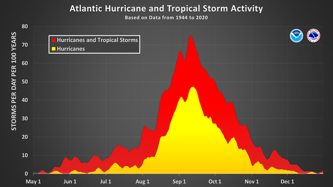
This chart shows the amount of tropical cyclone activity, in terms of named storms and hurricanes, that occurs in the Atlantic Basin on each calendar day between May 1 and Dec. 31. Specifically, it shows the number of hurricanes (yellow area) and the combined named storms and hurricanes (red area) that occur on each calendar day over a 100-year period. The chart is based on data from the 77-year period from 1944 to 2020 (starting at the beginning of the aircraft reconnaissance era) but normalized to 100 years. The official hurricane season for the Atlantic Basin is from June 1 to Nov. 30, but tropical cyclone activity sometimes occurs before and after these dates, respectively. The peak of the Atlantic hurricane season is Sept. 10, with most activity occurring between mid-August and mid-October.
(National Hurricane Center / NOAA)
Reanalysis of those periods found high levels of stability and a low amount of available moisture, which are two ingredients for cyclone formation.
The combination of a waning El Niño and warm water temperatures in the Atlantic, Caribbean and Gulf of Mexico, set the basin up for a stage that has never been witnessed before.
"So that weird temperature distribution across the Atlantic of the water is going to affect the way the air flows across the Atlantic, too, and let’s say unpredictable in ways because this is not a pattern that we’ve ever seen before," said FOX Weather Hurricane Specialist Bryan Norcross. "So, when we get these patterns that are kind of off the charts, different than we have, where we can compare to a past hurricane season, it’s really impossible to put your finger on exactly how things are going to correlate."
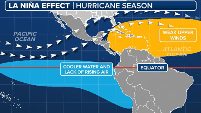
The impacts of La Niña on hurricane season.
(FOX Weather)
The odd state of the ocean hasn’t stopped some forecasters from calling for extreme activity in 2024. Many of those outlooks were made by the same people who expected the 2023-24 winter to be one of the coldest in a long time – a prognostication that couldn’t have been further from what actually happened.
Forecasters from Colorado State University, NOAA and other reputable organizations analyze computer models, which not only take into account sea temperatures but also complex atmospheric patterns such as the Madden-Julian Oscillation, North Atlantic Oscillation and others.
The hurricane outlook from CSU is to be released in April, and NOAA’s forecast will be made public in May.