Flash flooding threat in parts of Northeast could rival rainfall produced by Hurricane Irene in 2011
While flooding is possible across much of the Eastern Seaboard from the mid-Atlantic to the Northeast and New England, millions of Americans from Washington through Philadelphia, New York City and the state of Vermont face the most serious risk.
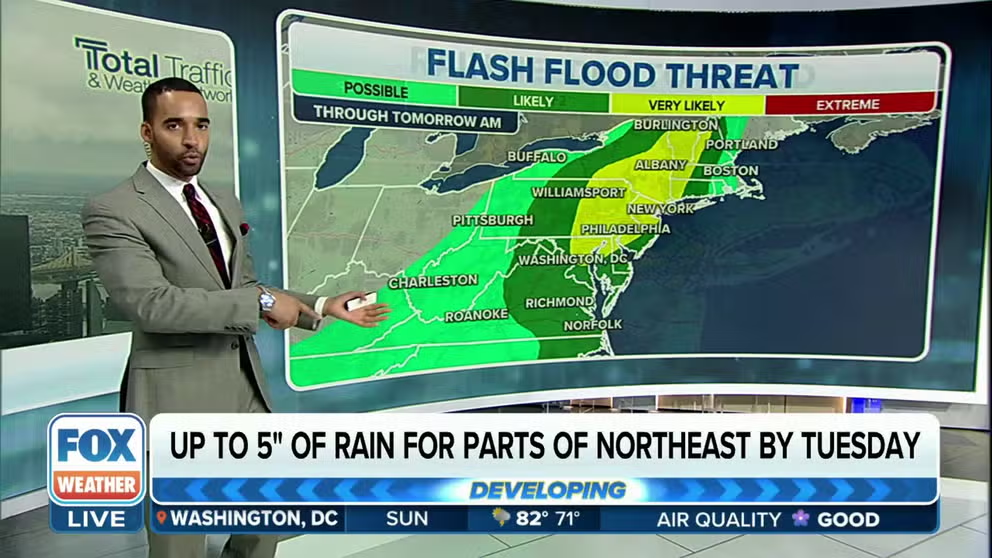
Flash flood threat for Northeast, New England continues through Monday
The FOX Weather Center is tracking the threat of flooding rains through Monday in the Northeast with New York, Vermont and New Hampshire appearing to be the hardest impacted.
A cold front moving through the Northeast with rounds of showers and thunderstorms has triggered the National Weather Service to issue Flood Watches for more than 40 million residents and warn some of the threat could rival that posed by Hurricane Irene in 2011.
On Sunday, dozens of water rescues were reported in communities in the Lower Hudson Valley and the NWS issued a rare Flash Flood Emergency for towns around West Point in New York.
Doppler radar estimates indicate around half a foot of rainfall occurred in areas of Orange County, New York, over a short time period leading to the flash flooding.
Due to the severe weather, Amtrak announced it suspended service from Albany to New York City and did state it when planned to resume operations in impacted parts of the Northeast Corridor.
HISTORIC RAINFALL PROMPTS WATER RESCUES, FLASH FLOOD EMERGENCY IN NEW YORK'S LOWER HUDSON VALLEY
![Flooding around West Point in New York]() Image 1 of 4
Image 1 of 4Flash flooding around West Point in New York (West Point Garrison and Community)
![New York flooding]() Image 2 of 4
Image 2 of 4Rockland County- Palisades Interstate Parkway flooding. (New York State Police)
![New York flooding]() Image 3 of 4
Image 3 of 4Rockland County- Palisades Interstate Parkway flooding. (New York State Police)
![Flooding around West Point in New York]() Image 4 of 4
Image 4 of 4Flash flooding around West Point in New York (West Point Garrison and Community)


More than 40 million at risk of flooding through Tuesday
Rainfall amounts of 1-3" inches have already impacted parts of the Northeast with some communities seeing upwards of a foot of rainfall in the Hudson Valley.
Most major cities in the Megalopolis along Interstate 95 are under the Flood Watch, including Washington, Philadelphia, New York and Hartford.
(FOX Weather)
NOAA placed areas of upstate New York and Vermont under an extreme risk for flash flooding, and NWS meteorologists warn some of the expected flooding could threaten records produced during Hurricane Irene of 2011.
The hurricane produced a widespread swath of 5-8" which led to mudslides and deadly flooding.

(FOX Weather)
Burlington, Montpelier and Plattsburgh in Vermont are included in the zone where rainfall could be extreme through Tuesday morning.
(FOX Weather)
Elsewhere, an additional 1 to 3 inches of rain could fall in southern New York, Connecticut, Rhode Island and Massachusetts.
U.S. HAS ENTERED PEAK FLASH FLOOD SEASON

(FOX Weather)
Rainfall is welcome news in communities dealing with drought conditions
Before the rain began, more than 60% of the Northeast was facing either dry or drought conditions.
The lack of precipitation over the winter and through the first half of 2023 has caused farmers to rely on irrigation instead of Mother Nature's natural sprinkler system.
Observation sites around Washington report being around 7 inches below average, while New York's Central Park has over a 3-inch rainfall deficit.
Unlike in the Plains, no counties in the Northeast are experiencing extreme or exceptional drought conditions.
(FOX Weather)