NOAA outlook forecasts warm spring for most of US while Southeast remains wet
NOAA’s National Water Center is predicting a lower-than-average flood risk across the U.S. due in part to historically low winter snow cover across the northern Plains, Upper Midwest and western U.S.
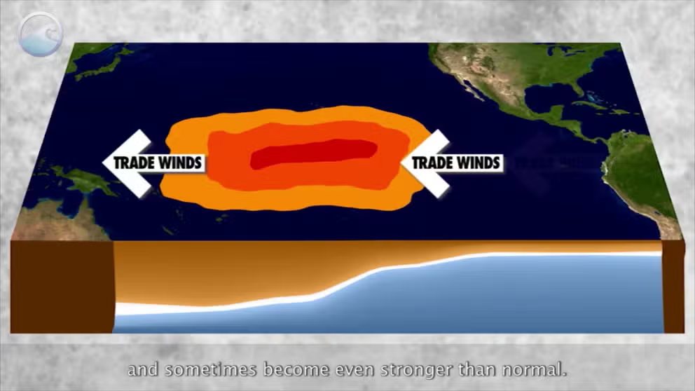
The meaning of El Nino and La Nina
The status of whether the world is being impacted by an El Nino or a La Nina is determined by water temperatures in the central and eastern Pacific. (NOAA)
NOAA’s Climate Prediction Center (CPC) released its spring outlook on Thursday and predicts most of the lower 48 U.S. states and Alaska will see above-average temperatures through June while wetter than average conditions are expected in the Plains and Southeast.
At the same time, NOAA’s National Water Center is predicting a lower-than-average flood risk across the U.S. due in part to historically low winter snow cover across the northern Plains, Upper Midwest and western U.S.
"Climate change is affecting the timing, intensity and duration of weather events in the United States," NOAA Administrator Dr. Rick Spinrad said in a news release. "The Spring Outlook is one of the many tools NOAA provides to help communities prepare for what’s ahead."
Most of U.S. could see above-average temperatures into summer

(FOX Weather)
The spring outlook shows that most of the U.S. will continue to see above-average temperatures in April, May and June.
The greatest chance for above-average temperatures will be found in the Great Lakes region and parts of the Midwest, including cities such as Minneapolis and Chicago, the Pacific Northwest, including Seattle and Portland in Oregon, and in northwestern Alaska.
However, most of the nation will have increased odds of experiencing warmer-than-average temperatures this spring. NOAA noted that no area of the U.S. is predicted to have a cooler-than-average spring.
Outlook shows wetter Southeast, drier Northwest

(FOX Weather)
The CPC is also predicting that above-average precipitation is possible across portions of the central Plains through the Deep South and Southeast, as well as in southern Alaska.
This includes cities such as Omaha in Nebraska; St. Louis in Missouri; Montgomery and Birmingham in Alabama; Atlanta in Georgia; New Orleans in Louisiana and Tallahassee, Tampa, Orlando and Miami in Florida.
On the flip side, below-average precipitation is predicted for the Northwest, including Seattle and Portland, as well as in the Southwest, including portions of West Texas and New Mexico, including Santa Fe and Albuquerque.
El Nino-fueled rain helps ease drought

(FOX Weather)
There has been some improvement in drought conditions in the U.S., although moderate to exceptional drought continues to exist across less than 20% of the U.S. and Puerto Rico.
The CPC said this is an improvement over last year, as El Niño-fueled rain fell during the winter across the Gulf Coast region.
The CPC also said that drought conditions are likely to continue to improve in the southwestern U.S., but drought is likely to persist or even expand through portions of the Rocky Mountains in the West, as well as in the northern and southern Plains.
However, the CPC said while El Niño is expected to continue to impact weather patterns across the U.S. into the early spring, there is now an 83% probability that neutral conditions, meaning neither El Niño nor La Niña, will take over during the April-May-June timeframe.
Long range forecasts show further change to La Niña conditions in the summer, and a La Niña Watch remains in effect.
"Our scientists at the Climate Prediction Center observed one of the strongest El Niño events on record during the winter of 2023-2024," Chief of the Operational Prediction Branch from NOAA’s Climate Prediction Center Jon Gottschalck said in the news release. "But a quick transition to La Niña — the cool phase of ENSO — is possible as early as the first part of summer."
Mississippi River may encounter low flow problems again, CPC says

(FOX Weather)
The CPC said that the overall threat of significant spring flooding in the U.S. is low due to the above-average temperatures and historically low snowpack over the winter.
However, moderate flooding is expected in climatologically flood-prone areas of the Midwest and in the South.
"This is the first Spring Outlook since 2021 with no population expected to be impacted by major flooding," Director of NOAA’s National Water Center Ed Clark said in the news release.
The lack of snowpack and significant winter precipitation, along with the spring outlook, suggests that low flow conditions may return to the Greater Mississippi River Basin later this year.
"Of growing concern will be the potentially low flows on the Mississippi River this summer into fall due to well-below snowpack and precipitation in most of the northern Plains and Midwest," Clark said. "This could have potential impacts on those navigation and commercial interests that depend on water from the Mississippi River."
Last year, President Joe Biden approved an emergency declaration in Louisiana due to historically low water levels of the Mississippi River that allowed for saltwater to intrude farther upstream, threatening drinking water in cities like New Orleans.