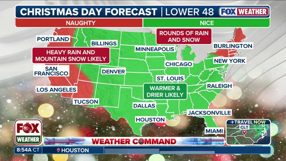
Christmas weather outlook: Millions to see 'nice' forecast with a touch of 'naughty' across nation
In anticipation of the big holiday, the FOX Forecast Center complied a list, and they're checking it twice. Naughty, nice or somewhere in between; here's what to expect across the US for Christmas.
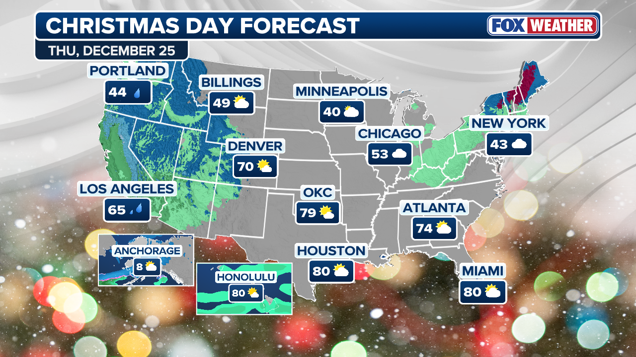
Christmas Forecast: Mostly warm across US, significant California flood threat
A dangerous flood threat has been issued for Southern California on Christmas Eve into Christmas Day, expect major travel delays. Meanwhile, it will be warm across much of the rest of the country across the Christmas holiday. Those hoping for a White Christmas will need to head to elevation in the Sierra, the interior Northeast, or close to the Canadian border in the Northern Tier.
No Christmas traveler has a more important load than Santa Claus.
Traversing the world by flying a sleigh in one day isn't recommended, but if you dare attempt, understanding the weather is essential.
THE SHORTEST DAY OF THE YEAR IS APPROACHING: WHAT YOU NEED TO KNOW ABOUT THE WINTER SOLSTICE
In anticipation of the big holiday, the FOX Forecast Center compiled a list, and they're checking it twice. Naughty, nice or somewhere in between; here's what to expect across the US for Christmas.
(FOX Weather)
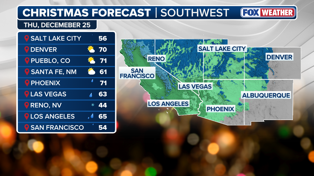
SOUTHWEST: NAUGHTY
One region that looks to remain wet and active is the Southwest, which is why the forecast is NAUGHTY.
Rain is expected to move down the coast through Central and Southern California into Christmas Eve and Christmas Day, significantly impacting holiday travel along the I-5 corridor.
RARE 'HIGH RISK' OF DANGEROUS FLOODING IN LOS ANGELES AREA CAUSES CONCERN FOR CHRISTMAS EVE
The National Weather Service (NWS) is warning of an extreme flood threat for downtown Los Angeles, the San Fernando Valley, as well as parts of Ventura and Santa Barbara counties, beginning on Christmas Eve through Christmas Day. The NWS said rock and mudslides are expected.
(FOX Weather)
Rounds of moisture are expected to funnel through portions of California and the Intermountain West. This could increase the risk of flooding and bring snow to the mountains of the Sierras and Rockies late into the Christmas week.
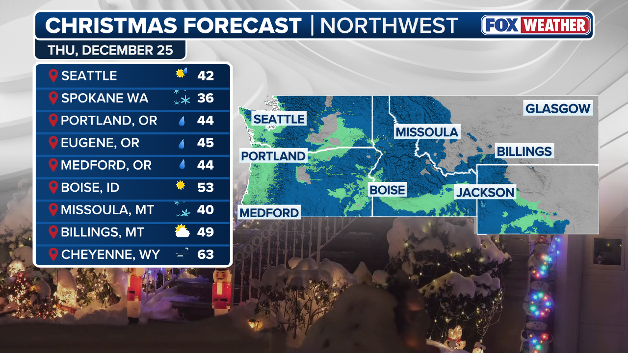
NORTHWEST: NICE
While the Northwest forecast is tagged as NICE, that’s relative to what the region has been experiencing. A few showers are expected, which is normal for this time of year, but it won’t be a washout.
Rain showers are possible in areas like Seattle and Portland into Christmas Day, with some light mountain snow as well. Because the precipitation is not intense, travel impacts should be minimal.
(FOX Weather)
Conditions may continue to evolve, so continue to check in with FOX Weather.
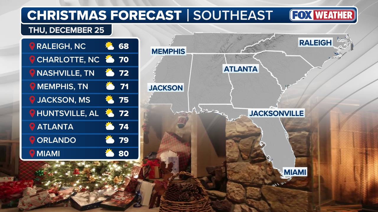
SOUTHEAST: A TAD NICE, A TAD NAUGHTY
With a large ridge of high pressure settling over the central portions of the Lower 48, much of the Southeast will remain quiet with no significant weather expected through Christmas Eve and Christmas Day.
(FOX Weather)
While the forecast is being tagged as NICE for most, with overnight lows in the 50s and 60s through Christmas Eve, weather will be NAUGHTY across the Gulf Coast states, where fog will continue to be an issue, especially in the morning hours.
Travelers from New Orleans west to Houston to Corpus Christi will be met with locally dense fog. Visibilities will rapidly drop off to as low as a quarter-mile in some locations.
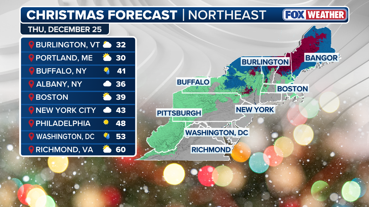
NORTHEAST: NAUGHTY
Because of greater confidence in an unsettled pattern into late Christmas week, the Northeast forecast has been deemed NAUGHTY.
Computer forecast models are growing more confident that a storm system could ride along the northern edge of the ridge of high pressure over the central U.S. and move into the Great Lakes and Northeast by Friday. This system could bring a mix of snow, rain and even ice to the region.
(FOX Weather)
The storm is currently forecast to arrive Friday afternoon into Saturday, so any travel home from holiday plans may be impacted.
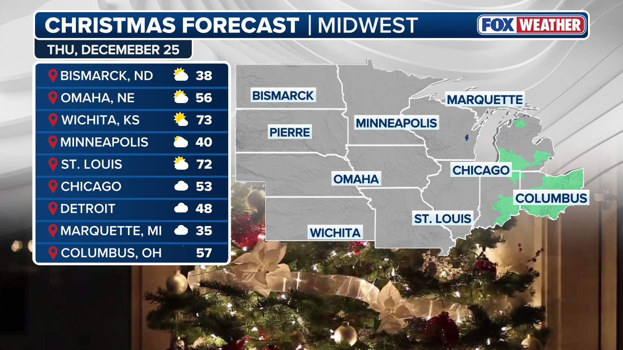
MIDWEST: NICE
Overall, the Midwest looks pretty NICE heading into Christmas Day, especially compared to the past few weeks. While snow or rain showers are possible, conditions should remain generally quiet for those traveling to see family and friends.
(FOX Weather)
Temperatures will stay slightly above average, with lows in the 20s across the Dakotas and Minnesota. Highs on Christmas Day are expected in the 30s and 40s across the Plains and Midwest, about 5-15 degrees above average for this time of year.
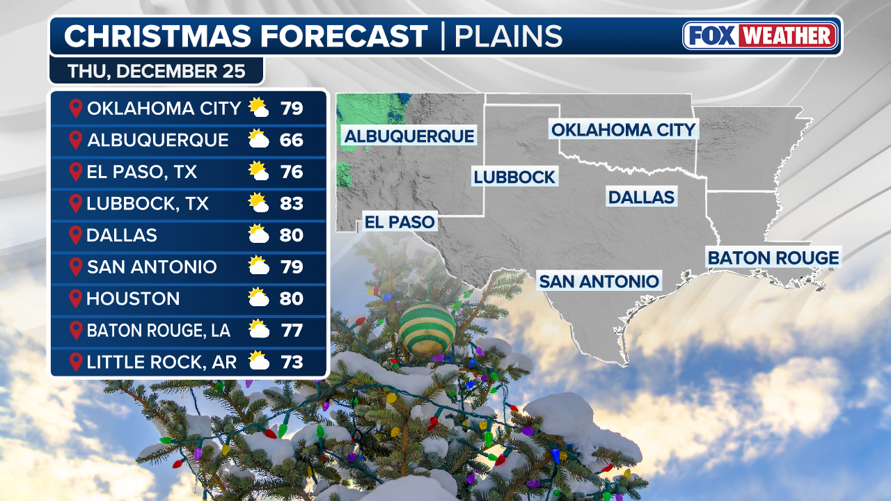
SOUTHERN PLAINS: NICE
The Southern Plains will likely remain under a large ridge of high pressure through Christmas Day. While that may sound concerning, it’s actually why the forecast is being tagged as NICE.
(FOX Weather)
High pressure brings sinking air, which limits the chance of rain across the region. Temperatures will remain unseasonably warm, running 10 to 20 degrees above average. Highs on Christmas Day could reach the 70s and low 80s from Oklahoma City through Houston. There will likely be record highs early Christmas week in this region and may persist into Christmas day. This includes major cities such as Kansas City and Oklahoma City. This could be some of the warmest Christmas Day temperatures ever on record for over 60 locations.