NWS: 'Dangerous scenario is unfolding,' Los Angeles braces for rare 'High Risk' flood threat through Christmas
When a high risk – the highest risk level that can be issued – is in place, it means severe, widespread flash floods are expected.

Los Angeles area bracing for 'highest risk' of life-threatening floods Christmas Eve
Officials in Los Angeles are warning people about the imminent potential for life-threatening flooding Wednesday, asking people to stay aware as they celebrate Christmas Eve. The National Weather Service has issued the highest flash flood risk for parts of Los Angeles, Ventura and Santa Barbara counties through Wednesday. A powerful storm is moving onshore after days of rain have saturated soils, creating prime conditions for dangerous flooding. Mudslides and debris slides are expected, according to the NWS.
LOS ANGELES — A powerful storm with the potential for life-threatening flash flooding is moving onshore over California early Wednesday, threatening to be one of the wettest Christmas Eve-to-Christmas Day periods on record for Los Angeles.
FLOOD THREAT RENEWS FOR MILLIONS ACROSS NORTHERN CALIFORNIA AFTER DEADLY WEEKEND INUNDATION
"A dangerous scenario is unfolding," the National Weather Service (NWS) warned early Wednesday.

(FOX Weather)
The NWS' Weather Prediction Center issued a rare Level 4 out of 4 "High Risk" of flash flooding for places just north of Los Angeles in Santa Clarita, Burbank and Glendale through Christmas morning. Los Angeles itself is under a Level 3 flood threat, as the region, home to more than 12 million people, prepares for a widespread 3-5 inches of rain within a 24-hour period.
WHY RARE 'HIGH RISK' FLOOD DAYS NEED TO BE TAKEN SERIOUSLY
Flash Flood Warnings were issued early Wednesday across Santa Barbara and Ventura counties.
L.A. officials emphasized the severity of the flood threat on Tuesday, asking people to stay aware as they celebrate Christmas Eve and prepare for potential Flash Flood Emergencies.
This comes after days of rain have saturated soils, creating prime conditions for dangerous flooding. Mudslides and debris slides are expected, according to the NWS.
![ALTADENA, CA - DECEMBER 23, 2025: Bob Ganguin of Altadena places sandbags at the end of his driveway in preparation for the forecasted storm to arrive Tuesday night on December 23, 2025 in Altadena, California.]() Image 1 of 4
Image 1 of 4ALTADENA, CA - DECEMBER 23, 2025: Bob Ganguin of Altadena places sandbags at the end of his driveway in preparation for the forecasted storm to arrive Tuesday night on December 23, 2025 in Altadena, California. ((Gina Ferazzi / Los Angeles Times via Getty Images))
![ALTADENA, CA - DECEMBER 23, 2025: Dave Racs of Altadena steps over one of the large hay filled burlap rolls he placed around his property to keep mud and debris from flowing onto his property once the forecasted storm hits on December 23, 2025 in Altadena, California. He lost his 100 year old home in the Eaton fire and is now living on the property in an RV.]() Image 2 of 4
Image 2 of 4ALTADENA, CA - DECEMBER 23, 2025: Dave Racs of Altadena steps over one of the large hay filled burlap rolls he placed around his property to keep mud and debris from flowing onto his property once the forecasted storm hits on December 23, 2025 in Altadena, California. He lost his 100 year old home in the Eaton fire and is now living on the property in an RV. ((Gina Ferazzi / Los Angeles Times via Getty Images))
![Altadena, CA - December 22: Signs at a location where Los Angeles County Public Works Department workers distribute sandbags to residents at a county works public yard on Monday, Dec. 22, 2025 in Altadena, CA.]() Image 3 of 4
Image 3 of 4Altadena, CA - December 22: Signs at a location where Los Angeles County Public Works Department workers distribute sandbags to residents at a county works public yard on Monday, Dec. 22, 2025 in Altadena, CA. ((Eric Thayer / Los Angeles Times via Getty Images))
![LOS ANGELES, CALIFORNIA - NOVEMBER 20: Rain falls from storm clouds over downtown as seen from the Baldwin Hills neighborhood on November 20, 2025 in Los Angeles, California, during multiple days of a storm that triggered evacuation and flash flood warnings in Southern California.]() Image 4 of 4
Image 4 of 4LOS ANGELES, CALIFORNIA - NOVEMBER 20: Rain falls from storm clouds over downtown as seen from the Baldwin Hills neighborhood on November 20, 2025 in Los Angeles, California, during multiple days of a storm that triggered evacuation and flash flood warnings in Southern California. ((Photo by Apu Gomes/Getty Images))


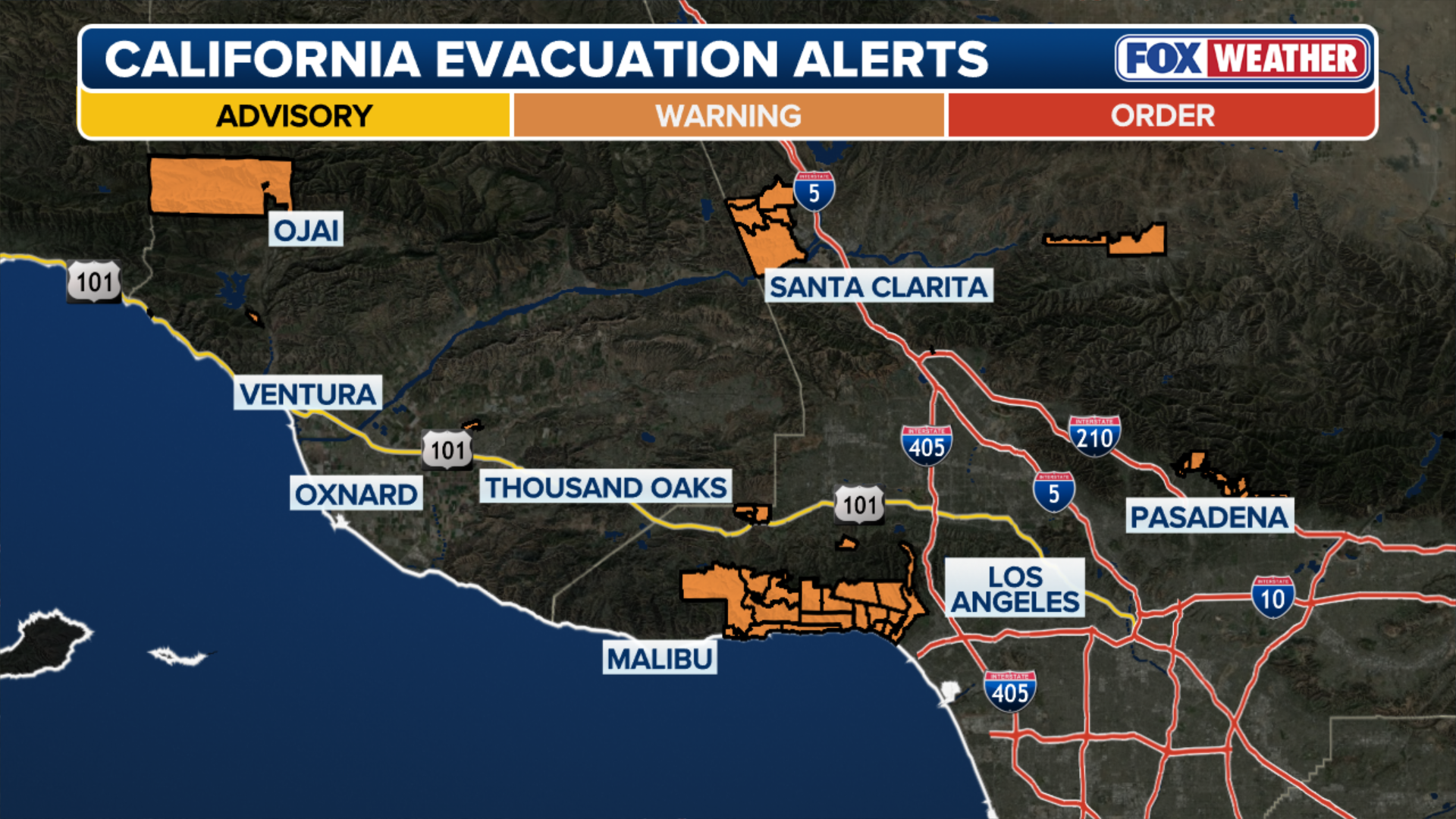
The Los Angeles Fire Department has issued evacuation warnings for debris flows for several areas around burn scars from January's wildfire disaster through 11 p.m. Thursday.
WHAT IS A WILDFIRE BURN SCAR AND HOW COULD THEY HAVE LASTING IMPACTS?
Ash from wildfires creates burn scars—a water-repellent coating that prevents the ground from absorbing water and causes the area to be predisposed to flash flooding and debris flows.
People near the Palisades and Eaton Fire burn scars were urged to take protective action earlier in the week. The Los Angeles County Department of Public Works distributed sandbags in Altadena and other vulnerable communities.
Visit the City of Los Angeles website for the latest on evacuation orders.
(FOX Weather)
The FOX Forecast Center warns that as the system moves onshore, atmospheric instability will be high enough to trigger severe thunderstorms, some of which could even produce a tornado.
7 FACTS YOU SHOULD KNOW ABOUT FLASH FLOODS
In addition to the heavy rain, this storm system could pack wind gusts up to 80 mph along the coast.
Wind Alerts have been issued for most of the California coast through Thursday.

(FOX Weather)
This comes after an atmospheric river soaked the region over the weekend and produced deadly flash floods in the northern part of the state.
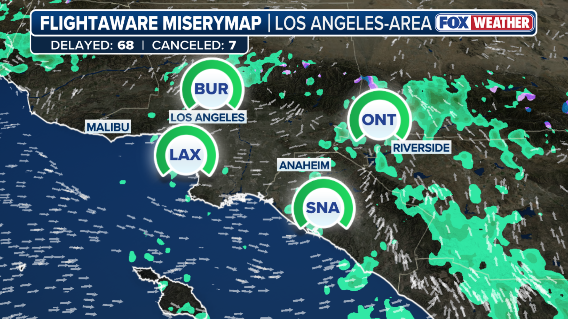
The rain snarled holiday travel and could cause yet more delays Wednesday at San Francisco International and Los Angeles International Airport.
(FOX Weather)
While the heaviest rainfall is expected Wednesday, a Level 2 out of 4 risk of flash flooding covers San Luis Obispo and extends across much of the Transverse Ranges north of Los Angeles through Thursday.
Flood Watches remain in effect for much of the entire state through Friday.
Explaining Flood Alerts from the NWS
Flood alerts? The National Weather Service has been issuing flood alerts for years. Here is how to understand them and what they mean.
"High Risk" flood threats are only issued on about 4% of days (including tropical and non-tropical events), but this risk category accounts for 39% of flood-related fatalities and 83% of flood-related damages in the continental U.S., according to research by Weather Prediction Center meteorologists.
Research shows that 6% of high-risk flood days have at least one fatality or injury, and 62% of such days have at least $1 million in damages.
This level of threat can produce impassable inundation in areas that have never flooded in the past.

(FOX Weather)
Meanwhile, those driving over the Sierras should expect mountain pass closures and hazardous travel conditions beginning Tuesday through Friday.
Feet of snow are expected to fall on the Sierras through the holiday week, with snow levels dropping to 5,000 feet.
Winter Weather Alerts have been issued for the Sierras through Friday.
Be sure to keep tabs on your FOX Weather app and any government-issued alerts from the NWS that will warn you of life-threatening flooding at your location.