Clipper bringing snow to Detroit as system slices through Great Lakes region
It's not a strong storm system, but the FOX Forecast Center said it has the potential to produce heavy bursts of winter weather that could impact travel in the region.

Fast-moving clipper dumps snow, rain on Great Lakes
A fast-moving clipper system is moving across the Great Lakes region on Tuesday and bringing rain and snow to the region leading to some slower drive times on the roads.
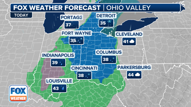
DETROIT – The weather is expected to be relatively quiet across the eastern half of the U.S. this week, but the FOX Forecast Center is tracking a fast-moving clipper system that pushed in from Canada and is delivering snow, freezing rain and rain to portions of the Midwest and Great Lakes on Tuesday.
It's not a strong storm system, but the FOX Forecast Center said it has the potential to produce heavy bursts of winter weather that could impact travel in the region.
WHAT IS AN ALBERTA CLIPPER, MANITOBA MAULER, SASKATCHEWAN SCREAMER?

(FOX Weather)
The FOX Forecast Center noted that Michigan has the highest chance of seeing accumulating snow, although it will be light.
Regarding snow totals, the FOX Forecast Center expects no more than an inch or two in places like Saginaw and Detroit in Michigan.

(FOX Weather)
A mix of rain, snow and freezing rain will expand to the south and west into Illinois, Indiana and Ohio through the day on Tuesday.
On Tuesday night, the precipitation is expected to reach the central Appalachians, where the higher elevations will be cold enough to allow it to remain all snow.
Slick travel conditions are expected there for anyone heading out onto the roads Tuesday night.
6 BASIC STEPS FOR PROPERLY MEASURING SNOW
![The forecast on Tuesday, Jan. 30, 2024.]() Image 1 of 3
Image 1 of 3The forecast on Tuesday, Jan. 30, 2024. (FOX Weather)
![The Tuesday night forecast on Jan. 30, 2024.]() Image 2 of 3
Image 2 of 3The forecast on Tuesday night, Jan. 30, 2024. (FOX Weather)
![The forecast on Wednesday, Jan. 31, 2024.]() Image 3 of 3
Image 3 of 3The forecast on Wednesday, Jan. 31, 2024. (FOX Weather)


The snow is then expected to wind down on Wednesday as the system continues to slide off to the east, bringing rain to the Carolinas and Virginia in the mid-Atlantic.
The system is expected to exit off the East Coast on Wednesday night, bringing an end to the precipitation.