Los Angeles faces renewed wildfire threat as more destructive Santa Ana winds remain in forecast
Another strong Santa Ana wind event with potentially damaging wind gusts is looming for Tuesday. “There is great concern that fire weather conditions could become exacerbated given the antecedent conditions," NWS Los Angeles forecasters wrote.

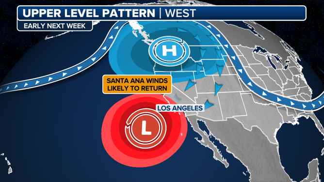
More rounds of Santa Ana winds loom next week
Forecasters are watching renewed firefighting threats for next week as offshore Santa Ana winds are predicted to return on Tuesday.
LOS ANGELES — Southern California is getting to get a much-needed break Saturday morning from the relentless Santa Ana winds whose destructive wind-fueled firestorms left at least 10 people dead and neighborhoods in ruins.
The break won't last long, with additional damaging Santa Ana wind threats and critical fire weather danger continuing at times over the next several days.
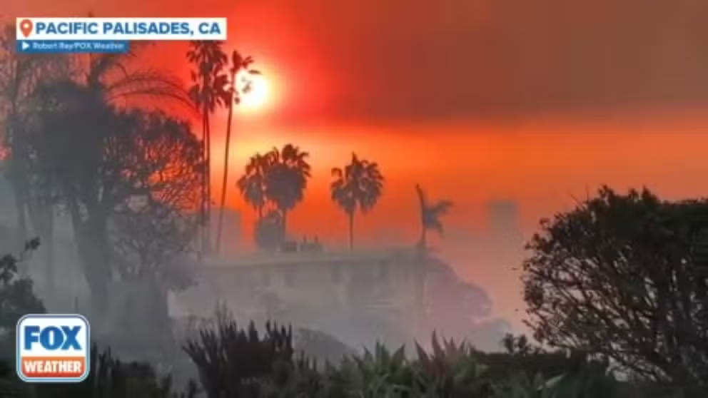
Charred remains of homes seen in Pacific Palisades after deadly California wildfires
FOX Weather's Robert Ray recorded this video of the aftermath of the Palisades Fire that ripped through parts of the Los Angeles metro area.
While winds are not expected to reach the extreme levels seen during Tuesday night’s storm that registered widespread gusts from 80-100 mph, potentially damaging winds remain in the forecast into next week as the weather pattern features renewed offshore wind threats.
But firefighters will take a reprieve from the winds that will last from Friday afternoon through Saturday – with even a brief shift to onshore winds that will increase the humidity from bone-dry levels of the last several days.
The lingering wind alerts from the week of damaging winds expire Friday afternoon, and gusts Friday night and Saturday are expected to only reach 20-30 mph in the mountains and 10 mph or less in the valleys.
Some strong offshore wind returns Saturday night
A more "classic Santa Ana" wind event will bring a return of gusts to 40-50 mph in the mountains and their passes Saturday evening, with lower speeds in the valleys but still enough to fan the flames of any burning wildfire. Fire Weather Watches are in effect for Los Angeles and Ventura Counties.
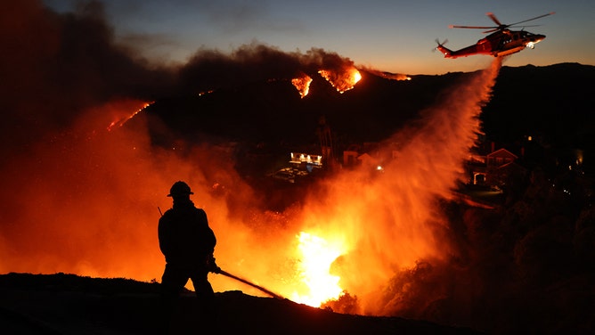
![Firefighters continue battling Palisades fire as flames rage across Los Angeles, California, United States on January 09, 2025. (Photo by Official Flickr Account of CAL FIRE / Handout/Anadolu via Getty Images)]() Image 1 of 11
Image 1 of 11Firefighters continue battling Palisades fire as flames rage across Los Angeles, California, United States on January 09, 2025. (Photo by Official Flickr Account of CAL FIRE / Handout/Anadolu via Getty Images) ( )
![]() Image 2 of 11
Image 2 of 11First light reveals oceanside homes destroyed by Palisades Fire in Malibu, CA (Robert Ray, Jan. 9, 2025) (Robert Ray)
![A destructive wind event, possibly the strongest to hit the LA Basin in 14 years, is fueling catastrophic fires across Southern California.]() Image 3 of 11
Image 3 of 11A destructive wind event, possibly the strongest to hit the LA Basin in 14 years, is fueling catastrophic fires across Southern California. (Robert Ray)
![LOS ANGELES, UNITED STATES - JANUARY 09: Fire destroys buildings and vegetation as flames rage across Los Angeles, California, United States on January 09, 2025.]() Image 4 of 11
Image 4 of 11LOS ANGELES, UNITED STATES - JANUARY 09: Fire destroys buildings and vegetation as flames rage across Los Angeles, California, United States on January 09, 2025. (Official Flickr Account of CAL FIRE / Handout/Anadolu)
![Flames from the Palisades Fire burn a building on Sunset Boulevard amid a powerful windstorm on January 8, 2025 in the Pacific Palisades neighborhood of Los Angeles, California.]() Image 5 of 11
Image 5 of 11Flames from the Palisades Fire burn a building on Sunset Boulevard amid a powerful windstorm on January 8, 2025 in the Pacific Palisades neighborhood of Los Angeles, California. (Apu Gomes/Getty Images)
![]() Image 6 of 11
Image 6 of 11Charred remains of a pickup truck in Malibu, CA (Robert Ray, Jan. 9, 2025) (Robert Ray)
![Fire personnel respond to homes destroyed while a helicopter drops water as the Palisades Fire grows in Pacific Palisades, California on January 7, 2025.]() Image 7 of 11
Image 7 of 11Fire personnel respond to homes destroyed while a helicopter drops water as the Palisades Fire grows in Pacific Palisades, California on January 7, 2025. ( DAVID SWANSON/AFP via Getty Images)
![]() Image 8 of 11
Image 8 of 11LOS ANGELES, CALIFORNIA - JANUARY 8: A firefighter battles the Palisades Fire while it burns homes at Pacific Coast Highway amid a powerful windstorm on January 8, 2025 in Los Angeles, California. The fast-moving wildfire has grown to more than 2900-acres and is threatening homes in the coastal neighborhood amid intense Santa Ana Winds and dry conditions in Southern California. (Photo by Apu Gomes/Getty Images)
![]() Image 9 of 11
Image 9 of 11MALIBU, CA - January 08: A Tesla is melted into the street above Pacific Coast Highway in Malibu, CA on Wednesday, January 8, 2025. High winds escalated the spread of several blazes across Southern California. (Photo by David Crane/MediaNews Group/Los Angeles Daily News via Getty Images) ( )
![MALIBU, CA - January 08: Beachfront homes go up in flames along Pacific Coast Highway near Carbon Canyon in Malibu, CA on Wednesday, January 8, 2025. High winds escalated the spread of several blazes across Southern California.]() Image 10 of 11
Image 10 of 11MALIBU, CA - January 08: Beachfront homes go up in flames along Pacific Coast Highway near Carbon Canyon in Malibu, CA on Wednesday, January 8, 2025. High winds escalated the spread of several blazes across Southern California. (David Crane/MediaNews Group/Los Angeles Daily News)
![Flames from the wind-driven Eaton Fire engulf a house in Altadena, California, January 8, 2025. A ferocious wildfire in a Los Angeles suburb devoured buildings and sparked panicked evacuations January 7, as hurricane-force winds tore through the region.]() Image 11 of 11
Image 11 of 11Flames from the wind-driven Eaton Fire engulf a house in Altadena, California, January 8, 2025. A ferocious wildfire in a Los Angeles suburb devoured buildings and sparked panicked evacuations January 7, as hurricane-force winds tore through the region. (Robyn BECK / AFP)


Santa Ana wind gusts will hold into Sunday morning, then another break in the gusty winds is expected from Sunday afternoon through Monday.
Another potentially dangerous round of Santa Ana winds next week
Now, meteorologists are keeping a wary eye on the forecast for the middle of next week.
"The overall pattern looks something similar to what we saw earlier this week," said FOX Weather Meteorologist Ian Oliver. "High pressure up across portions of the Intermountain West. You get the northeast wind channel and down through some of those mountain passes, descending, compressing, warming and drying out as it approaches the coastline."
The drying aspect will once again drop relative humidity levels into the teens or single digit percentages. Forecast models predict a relative humidity of just 9% in Los Angeles on Tuesday afternoon.

(FOX Weather)
Meanwhile, wind gusts will near or exceed damaging levels in the Santa Ana wind-prone areas, especially in the mountains and passes around the Los Angeles area.

(FOX Weather)
"There is great concern that fire weather conditions could become exacerbated given the antecedent conditions, little rain across the area since the Spring of 2024, and another offshore wind event on top of all of what we have seen, so far," NWS Los Angeles forecasters wrote. "Residents are urged to stay tuned to the latest information and remain vigilant in steps to protect your life and property."
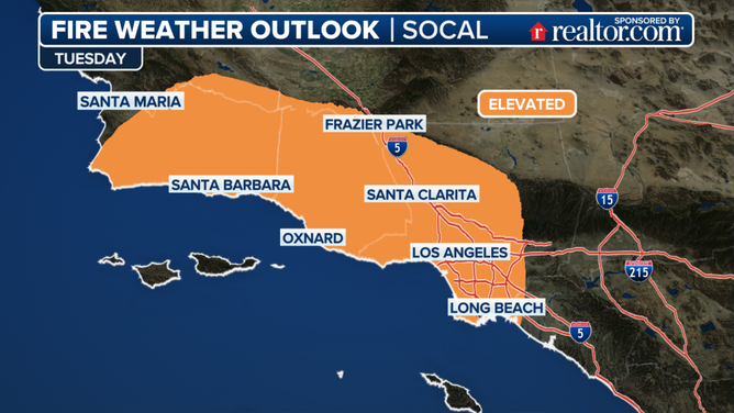
Tuesday Fire Weather Outlook
(FOX Weather)
That bout of wind is forecast to wane on Wednesday. But how does Southern California get out of this dangerously dry and windy pattern?
"The big issue and what would fix all of this is some rain," Oliver said.
There may indeed be a few raindrops falling from the skies over Southern California later next week as the long range forecast indicates another upper level low pressure center may drift off the coast.
"There is a 30 percent (chance) that it will pick up enough moisture to bring some very light rain to the southern portions of (Los Angeles) County," the NWS in Los Angeles said. But "rainfall if any, unfortunately, will be trivial.