Hawaii under Flash Flood Watch, Winter Weather Alerts due to Kona Low
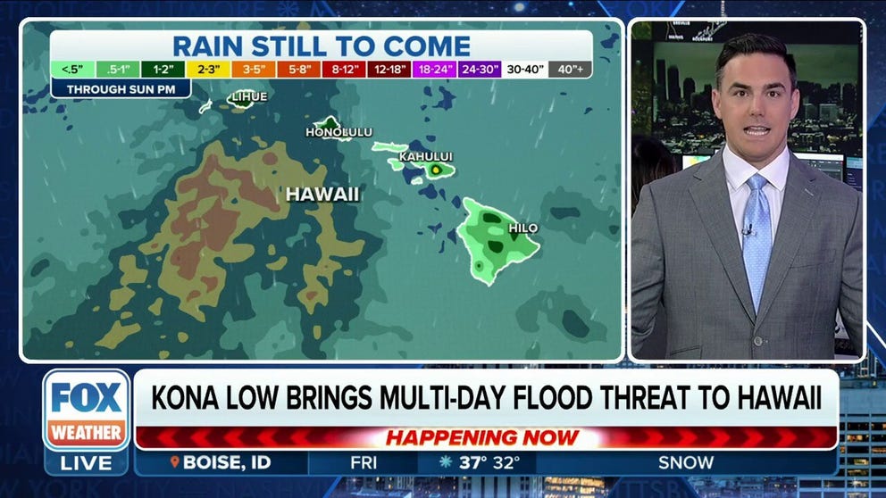
Flood Watches cover the entire state through Friday as several inches of rain are expected to fall into the weekend from the persistent soggy pattern. The heaviest rain is expected on the southern-facing windward slopes as the area of low pressure draws in surges of tropical moisture from the south.
Hawaii under Flash Flood Watch as Kona Low brings flooding rain
A Kona Low brings a multi-day flood threat to Hawaii this week, already dumping several inches of rain across parts of the Aloha State. Nov. 30, 2023.
HONOLULU – A Kona Low is soaking much of Hawaii this week with heavy tropical rainfall and occasional strong thunderstorms, putting a damper on the usually sunny paradise and triggering flash-flood concerns.
Flood Watches cover the entire state through Friday as several inches of rain are expected to fall into the weekend from the persistent soggy pattern. The heaviest rain is expected on the southern-facing windward slopes as the area of low pressure draws in surges of tropical moisture from the south.

(FOX Weather)
Previously, the National Weather Service in Honolulu issued Flash Flood Warnings for parts of Maui and the Big Island of Hawaii, and the warnings Thursday night.
In just the past 48 hours, between 3 and 7 inches of rain have been reported throughout the Aloha State, according to the FOX Forecast Center.
The heavy rainfall caused a landslide, briefly closing Highway 19 near Honomu on the Big Island Thursday morning, the Hawaii Police Department said. The road has since reopened, and no injuries have been reported.
A Winter Weather Advisory has also been issued for the Big Island summits until 6 a.m. local time Friday. This means that periods of snow, sleet or freezing rain will cause problems for travelers, the NWS said.
They noted that up to 5 inches of snow is expected to fall, with southwest winds gusting up to 35 mph. Blowing snow will significantly reduce visibility at times, with periods of near-zero visibility.

(FOX Weather)
The Kona Low will bring a reversal of winds from the typical northeasterly trade winds, so the usual rain-shadowed areas will instead take the brunt of the rainfall.
"It's actually coming from the equatorial Pacific, and it's pumping in a different direction than usual," FOX Weather Meteorologist Steve Bender said. "That's important to know because you have that rain-shadow effect, and many of these cities that are being battered with rain are in that leeward side, where they don't usually get that intensity of the rain."
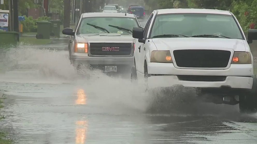
Heavy downpours cause flooded roads in Oahu, Hawaii
On Wednesday, Oahu, Hawaii, experienced heavy downpours that caused some roads to become flooded, resulting in drivers navigating through large puddles in Kakaako and Kalihi.
This unstable tropical moisture will spread periods of showers, heavy at times, and potentially strong thunderstorms with gusty winds across all islands from Thursday through Saturday.
HOW MOUNTAINS CAN HOG THE RAIN
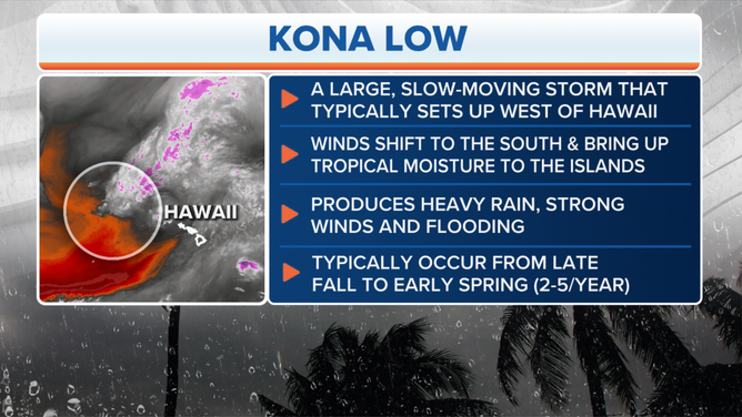
The characteristics of a Kona Low.
(FOX Weather)
Honolulu could pick up a few inches of rain through Saturday. The Big Island of Hawaii, including Hilo, could also see 2-3 inches of rain in the lower elevations, though rainfall totals could reach 5-8 inches or more along the Big Island’s volcano.
The rain is forecast to refocus on the western islands from Friday into the weekend.

(FOX Weather)
With recent extreme drought conditions – especially on the leeward sides of the islands – the region is ironically more prone to flash flooding, says KHON-TV Meteorologist Chevy Chevalier.
"These Kona Lows tend to stick with us for quite some time," Chevalier told FOX Weather. "So, I'd say flooding is our biggest concern, especially, you know, a lot of heavy rain on top of that dry ground, like water on a dry sponge. It tends to run off and give you flash flooding a lot faster."
In addition, gusty winds combined with freshly saturated soils could lead to downed trees and power lines.
"When we get any kind of winds with saturated grounds, we get trees falling, and we get power lines down quite a bit," Chevalier said.
The National Weather Service said flood-prone roads and low-lying areas may need to be closed due to the elevated runoff and overflowing streams. In addition, the NWS warned that urban areas may receive more significant flooding and property damage due to the rapid runoff.
Conditions should improve early next week as drier air moves in and the trade winds return.
Maui officials monitoring Lahania burn-scar area for potential flash flooding
Maui officials are closely monitoring the storm and its potential impact over the burn-scar areas of Lahania from the deadly fires on Aug. 8.
On Wednesday, Maui County officials said the NWS office in Honolulu issued a Special Weather Statement for Maui County. The statement said periods of heavy rain or isolated thunderstorms may impact the island, along with the islands of Moloka’i and Kaho’olawe, through the early afternoon.
The statement noted that "periods of rain exceeding one inch per hour could exacerbate localized flooding over recent burn scars in West Maui and on the western slope of Haleakala." The NWS added that gusty winds could blow around unsecured objects.
"Since the fires from August 8th, that area, Lahaina and leeward, portions of Maui especially, everything's gone," Chevalier said. "And the problem there is when you get heavy rain, there's really no buildings and the sewer systems are clogged and you get a lot of runoff fast. They don't need that."
WHEN CAN MAUI START REBUILDING? HOW TOXIC DEBRIS FROM DEADLY FIRES IS SLOWING RECOVERY
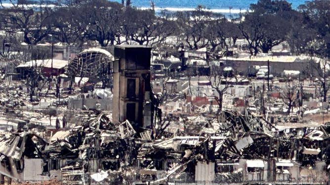
File: The burned out town of Lahaina.
(Robert Ray / FOX Weather)
The fire burned homes, commercial buildings, cars, asbestos and plastics, which released toxic substances. The ash and soil are contaminated. Flash flooding can wash the toxins into the ocean and water supplies.
"But they did a great job of cleaning up the toxic waste. They got most of it out of there," Chevalier explained. "So we think there will be minimal impacts when leeward portions of Maui start to get the heavy rain."
HOW WILDFIRE BURN SCARS COULD HAVE LASTING IMPACTS
Maui officials say a cutting-edge filtration system was installed in the fire's aftermath to capture, reduce and filter pollutants from stormwater runoff.
"They barricaded it out of the ocean to protect the ecosystem there, too," Chevalier said.
Why Kona Lows can be so dangerous
Kona Lows have had a history of trouble with Hawaii with their tropically infused downpours overwhelming the state with torrential rain and sometimes damaging wind gusts.
A Kona Low that struck in December 2021 dropped 2 feet of rain in Maui, washing some cars away. On Oahu, strong winds at Honolulu's airport blew a shed into parked planes, damaging the aircraft.
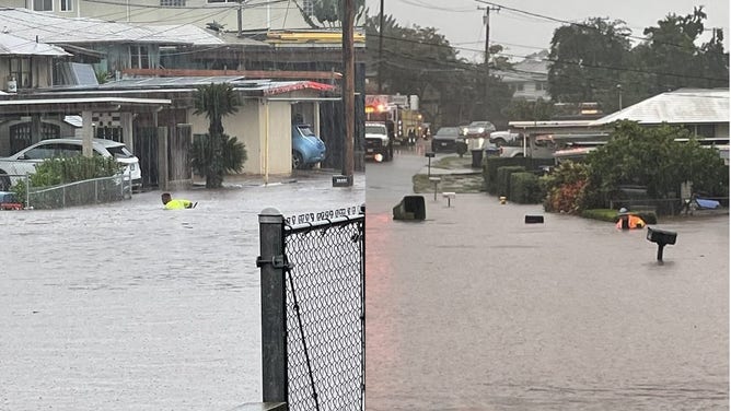
The Pearl City Road Maintenance Division had to wade chest deep in floodwater to clear storm drains in December 2021.
(Honolulu Mayor/Honolulu DEM / NOAA)
At Mauna Kea's summit, wind gusts over 100 mph created whiteout conditions, blowing around the 10 inches of snow that fell during the storm.
HOW A TROPICAL PARADISE IS HOME TO THE RAINIEST SPOT IN THE NATION
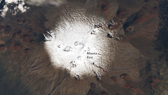
A snow-capped Mauna Kea on Hawaii on Dec. 7, 2021, as seen by Operational Land Imager (OLI) on Landsat 8.
(NASA / NASA)
Meanwhile, back in 2018, a Kona Low dropped a record-setting 49.69 inches of rain in 24 hours over Waipa Gardens on Kauai on April 14-15.
Silver lining? Ease the drought
Easing the drought is the silver lining to the flood threat for Hawaii.
Over 93% of the state is in moderate drought, and 75% is in severe drought, according to the latest U.S. Drought Monitor.
REMOTE HAWAII WILDFIRE COULD LEAD TO NEXT LAHAINA TRAGEDY, EXPERTS WARN
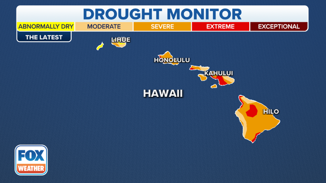
The Hawaii drought monitor.
(FOX Weather)