Atlantic hurricane season will start quiet, but there may be a window for tropical potential
The first named storm of the 2025 Atlantic hurricane season will be Andrea, followed by Barry, Chantal and Dexter. The name Dexter replaces Dorian, which was retired after the 2019 season.
What can we expect in June as 2025 Atlantic hurricane season gets underway?
The official start to the 2025 Atlantic hurricane season is Sunday, but that doesn't necessarily mean we'll have tropical activity right away. FOX Weather Meteorologists Michael Estime and Craig Herrera break down the outlook on May 29, 2025.
As June ushers in the official start of the Atlantic basin hurricane season, attention is once again turning to the tropics in search of the first signs of development.
Similar to patterns observed over the past three years, the season is expected to begin on a quiet note, with no named storms forecast to form in the opening days of the month. However, the big question is whether the rest of June will follow suit.
To help answer that question, forecasters often consult a variety of products, including tracking what is known as the Madden-Julian Oscillation, or what is commonly called the MJO.
This eastward-moving pulse of enhanced rainfall and lower atmospheric pressure typically circles the globe every 30 to 60 days and can significantly influence tropical weather patterns.
The MJO is divided into eight phases, each affecting different regions of the globe. When the MJO is in phases 8, 1 or 2, it generally leads to enhanced activity over the Atlantic basin and, if other conditions align, can increase the chances of tropical cyclone formation.
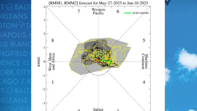
When the MJO is in phases 8,1 or 2 it generally leads to enhanced activity over the Atlantic basin.
(NOAA)
PATTERN EMERGES IN TROPICS FOR FIRST TIME IN MORE THAN 20 YEARS
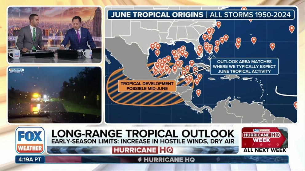
Because of the MJO’s current location and timing, forecasters expect only one favorable window for development in the Atlantic basin during June.
This period is likely to occur in the second half of the month, and the Caribbean and the Gulf are the most probable areas of interest.
This region is climatologically favored for development due to the presence of features that can aid in the formation of tropical cyclones, such as old frontal boundaries or the Central American Gyre, a large area of lower pressure.
The latest outlook from NOAA’s Climate Prediction Center points to a potentially favorable environment for tropical development during weeks two and three of the month.
While the outlook does not guarantee a named storm will form, it will lead to increased tropical moisture over Central America, Mexico, and possibly as far north as the Gulf Coast.
By late June and early July, atmospheric conditions may again become less conducive to development as the MJO continues its eastward progression around the globe.

NOAA's Climate Prediction Center weekly forecast
(FOX Weather)
2025 ATLANTIC HURRICANE SEASON GUIDE: HERE’S WHAT TO KNOW ABOUT THE TROPICS THIS YEAR
The formation date of the season's first named storm can be an important indicator of what’s to come.
Statistically, when the first named storm forms before June 20, it often signals a more active season ahead. On the other hand, if the season reaches early July without a named storm, it may serve as an indicator of a quieter-than-average year.
The last time the first named storm formed on or after June 20 was in 2014, when Arthur developed on July 1.
The year ended up being relatively subdued, with only eight named storms, six hurricanes and two major hurricanes - all well below the seasonal averages.
Although the Atlantic hurricane season officially runs from June 1 to November 30, losing the entire first month to inactivity effectively removes more than 16% of the season’s duration.
This lost time cannot be regained later in the year, as water temperatures typically decline and atmospheric stability increases, making storm formation less likely.
So, while the start of the 2025 hurricane season appears tranquil, forecasters will be closely monitoring the MJO and other key indicators in the coming weeks for any early hints of Andrea.