Hurricane Idalia, Hurricane Franklin put on powerful show as seen from space
Satellite imagery from NOAA showed the power of Hurricane Idalia and Hurricane Franklin at sunrise on Tuesday morning.
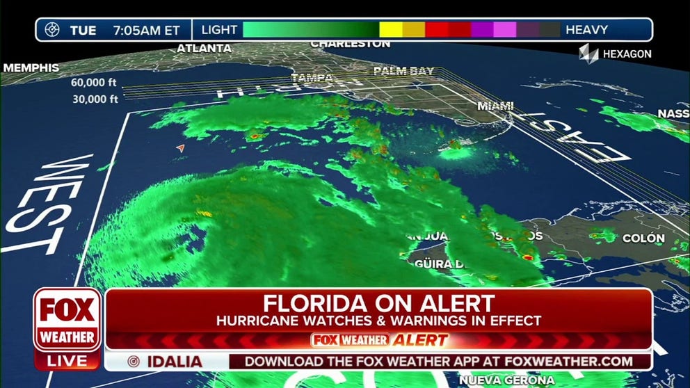
Florida on alert as Hurricane Idalia churns closer
Idalia is beginning to rapidly intensify in the Gulf of Mexico and is on a collision course with Florida. It is forecast to become a Category 3 hurricane, making landfall on Wednesday in the Big Bend area of Florida.
As hurricane season reaches its peak, two powerful hurricanes are currently swirling in the Atlantic basin.
Satellite imagery from NOAA showed Hurricane Idalia and Hurricane Franklin at sunrise on Tuesday morning.
HURRICANE IDALIA TIMELINE TRACKER: WHEN AND WHERE TO EXPECT IMPACTS IN FLORIDA
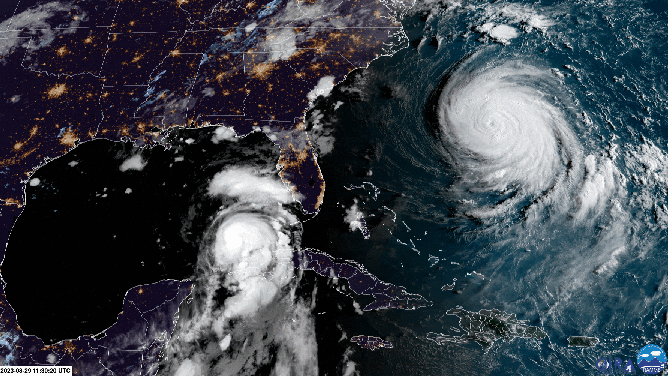
A satellite image of Hurricane Franklin and Hurricane Idalia on Tuesday, August 29, 2023.
(NOAA)
Data from a NOAA Hurricane Hunter aircraft indicate that Idalia's maximum sustained winds have increased to near 80 mph with higher gusts.

The International Space Station flew over Idalia on Tuesday.
(International Space Station / NASA)
Rapid intensification is likely through landfall, and Idalia is forecast to become an extremely dangerous major hurricane before slamming into Florida’s Gulf Coast on Wednesday, bringing life-threatening storm surge destructive winds and torrential rain to the region, the National Hurricane Center said.

(FOX Weather)
Hurricane Franklin becomes strongest storm in Atlantic so far
Meanwhile, Hurricane Franklin nearly reached Category 5 status Monday night before weakening a bit. According to Hurricane Franklin's forecast track, the center of the storm is predicted to pass far northwest of Bermuda on Wednesday.
Maximum sustained winds have decreased to near 130 mph with higher gusts. Franklin is still a Category 4 hurricane on the Saffir-Simpson Hurricane Wind Scale. Steady weakening is forecast during the next several days, the NHC said.
FRANKLIN REMAINS FORMIDABLE CATEGORY 4 HURRICANE WITH IMPACTS EXPECTED TO SPREAD UP EASTERN SEABOARD

(FOX Weather)
Life-threatening surf and rip currents generated by Franklin are already affecting Bermuda and the coast of the southeast U.S. These conditions are expected to spread northward along the east coast of the U.S. and Atlantic Canada later Tuesday into Wednesday, the NHC said.