Hurricane Hunters fly into Hilary to gather data for weather forecasts
This information is then sent to the National Hurricane Center, which uses the data to refine its forecast.

Hurricane Hunters gather data from Hilary's eye
Hurricane Hilary poses a serious threat to the Southwest. The National Hurricane Center uses computer models to forecast the storm, but those forecasts need data. That's where the Hurricane Hunters come in. Squadron navigator Lieutenant Colonel Steven Burton joins FOX Weather.
As Hurricane Hilary poses a serious threat to parts of California and the Southwest, the National Hurricane Center has deployed pilots and meteorologists known as "Hurricane Hunters" to fly into the storm to collect data.
One of the ways they collect data is to release dropsondes from the aircraft and into the eye of the storm. About the size of paper towel tubes, dropsondes parachute down and collect meteorological data, such as temperature, pressure, wind speed and relative humidity. This information is then sent to the NHC, which uses the data to refine its forecast.

FILE: An airman from the 53rd Weather Reconnaissance Squadron releases a weather instrument with a yellow parachute from an aircraft. August 5, 2021.
(U.S. Air Force by Staff Sgt. Kristen Pittman / FOX Weather)
"The oceans – the Atlantic, Pacific – are pretty data-sparse, so that's where what we do comes in, makes some pretty critical forecast improvements," said Lt. Col. Steven Burton, navigator for the 53rd Weather Reconnaissance Squadron, the official name of the Hurricane Hunters.
HOW HUNTING HURRICANES BECAME REBECCA WADDINGTON'S CALLING
Burton is also the mission commander for Hurricane Hunter crews flying into Hilary. According to his crews, Hilary was a pretty standard hurricane, and their flight was not very rough.
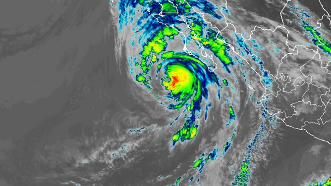
Tracking Hilary satellite
(NOAA / NOAA)
The Hurricane Hunters flew their first mission into Hilary on Friday. They are scheduled to return to Hilary on Saturday to investigate the system and collect more data, according to the NHC.
Hilary is currently located off the Mexican coastline as a Category 3 cyclone. It is expected to make landfall over the next 24 hours in Mexico before bringing rare, life-threatening flooding to California and the Southwest.