Florida slammed by tropical storm-like conditions, with flooding rains, gusty winds
Computer forecast models showed some areas potentially receiving more than a foot of rain by Friday, which could add to the already record-breaking rainfall levels experienced in the state this year.
Heavy rain falling over parts of Florida
Every major city in the Sunshine State is reporting rainfall. The FOX Forecast Center warns the threat for flooding will continue through Thursday.
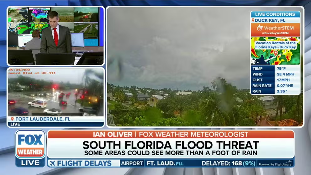
MIAMI – Torrential rains and gusty winds slammed much of Florida Wednesday, mimicking tropical storm-like conditions and leading to flash flooding and thousands of power outages. And the rain won't be letting up through Thursday.
Computer forecast models showed some areas potentially receiving more than a foot of rain by Friday, which could add to the already record-breaking rainfall levels experienced in the state this year.
Abundant tropical moisture began surging into the Sunshine State on Tuesday, and repeated showers and thunderstorms are expected to continue through at least through Thursday.
NOAA's Weather Prediction Center has upgraded the region's excessive rainfall risk to a Level 2 out of 4 in Central and South Florida, as rain rates could reach greater than an inch an hour.

(FOX Weather)
Poweroutage.us reported at least 20,000 customers were without electricity on Wednesday evening as the combination of wind gusts of 40-50 mph and heavy rainfall helped bring down some tree branches and utlitilty lines.
Miami-Dade and Broward counties were both put under a Flash Flood Warning through the morning hours, but the FOX Forecast Center was concerned the heavy rain could continue through the morning commute.
Both Broward County Public Schools and Broward College canceled classes on Thursday due to the inclement weather.

(FOX Weather)
A Flood Watch has been issued for parts of Central South Florida through Thursday.
MILLIONS IN FLORIDA FACE SIGNIFICANT FLASH FLOOD THREAT FROM TROPICAL DOWNPOURS
Overall, rainfall totals will likely reach 5-8 inches across much of the Miami and Fort Lauderdale area by Thursday, with isolated areas receiving as much as 10-12 inches.

(FOX Weather)
Fort Lauderdale passes 100 inches of rain in 2023
The additional rain comes as South Florida is already water-logged this week. Fort Lauderdale received 2.75 inches of rain Tuesday – a record for the day and pushing its annual precipitation to over 100 inches, marking only the second time the city has reached the century mark on record.
"Last night (Tuesday) was a tough one. We knew that it would be," FOX Weather meteorologist Britta Merwin said. "This is a spot that has been hit too hard this year. You know, the rain yesterday pushed them over the limit, figuratively and in reality."
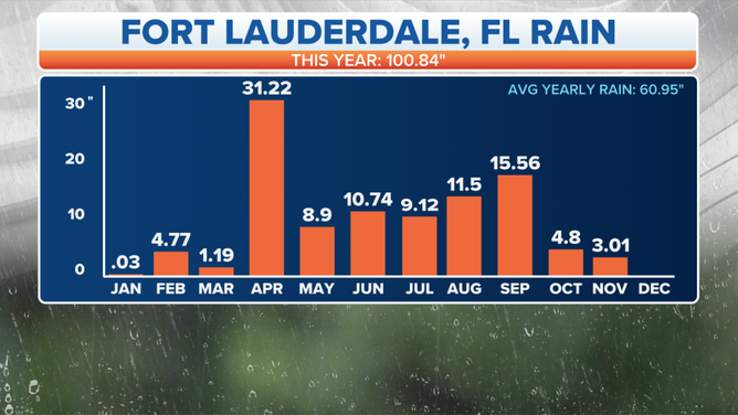
Fort Lauderdale has recorded 100.84 inches of rain this year.
(FOX Weather)
Meanwhile, the Gulf Coast has had below-average rainfall, but according to the National Weather Service, rain finally fell in Tampa Bay on Tuesday after 23 consecutive days without precipitation.
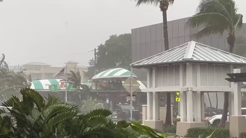
Wind, rain batter Deerfield Beach, Florida
The additional rain Wednesday comes as South Florida is already water-logged this week. Mike Nasiff captured this video Tuesday afternoon while on vacation in Deerfield Beach, Florida.
However, the records did not stop there. The NWS said after not recording any rainfall since October 21, Ruskin set a new daily rainfall record for Tuesday with 0.87 inches, breaking the old record of 0.53 inches in 1997.
WHAT DOES PERCENT CHANCE OF RAIN MEAN ON FOX WEATHER APP?
Storm has slight chance of tropical development
The National Hurricane Center has even outlined the storm for possible tropical development, though it is still a very low chance.
"Just because this is tagged by the Hurricane Center, it does not change the impacts," Merwin said. "And when you're talking about weak tropical systems and also non-tropical systems, it is truly about the impact. And we know the impact we're going to have – flooding rain."
The FOX Forecast Center said the system is also producing dangerous conditions on Florida's Atlantic beaches, including life-threatening rip currents and dangerous surf.

(FOX Weather)
Coastal flood alerts for Louisiana and Mississippi
Additionally, the Gulf Coast coastal areas stretching from Louisiana to Florida's Panhandle are under coastal flood alerts until Thursday. Gusty east winds of up to 45 mph are pushing elevated tides into the coastal lowlands, and causing some beach erosion and minor shoreline flooding.

(FOX Weather)
A Wind Advisory has also been issued for New Orleans area, effective until Thursday morning for gusts of 40-45 mph.
The Gulf Coast has been experiencing long-term drought conditions, making the recent rains a welcome sight.
Over half of Louisiana is currently in a state of 'exceptional drought,' the worst drought level. This has led to wildfires and smoky conditions, making driving dangerous and the air unhealthy. In Mississippi, almost 90% of the state is experiencing extreme and exceptional drought conditions.
Unfortunately, more than a week of rain won't be enough to end the drought in either state. Regular rainfall events will be needed to provide relief from the drought.