Flash flooding threat continues into weekend across central, southern US
The exceptionally wet stretch continues Thursday as the next in a parade of storms is forecast to deliver widespread rain and thunderstorms through the weekend.

Stubborn low anchors rain over the southcentral US
Widespread heavy rains continue across much of the U.S. A stubborn cutoff low is a slow mover and will anchor rain over the southcentral for days to come. Meteorologist Steve Bender explains.
Heavy rain continues to soak the central U.S. this week with not much sign of stopping. Houston will finally get a break after days of heavy rain as the lower Mississippi Valley gets ready for the deluge.
The exceptionally wet stretch continues Thursday as the next in a parade of storms is forecast to deliver widespread rain and thunderstorms through the weekend.
Many areas will welcome the inches of rain falling from the northern Rockies and Plains southward through the Rio Grande Valley of Texas. The worst drought in the country is currently in the Plains, and some areas are in desperate need of precipitation.
The downpours are not welcome in others areas like Houston, New Orleans and parts of Alabama, which shouldered the worst of the flood burden over the past few days.

Days of heavy rain swamps Houston
It's been a rough couple of days for Houston commuters. Heavy rain caused flooded streets. FOX Weather's Robert Ray shows us the soggy commutes.
FOX Weather's radar loop shows who has seen the heaviest rain in the past 3 hours.
"And so what we're going to watch is this giant swirl that's coming out – and when you're watching this, by the way, the most robust storms come from the northern Gulf," said meteorologist Steve Bender. "You see how that's entering towards Houma, Louisiana, pushing towards New Orleans, Tibideaux. In those spots when you incorporate the Gulf (moisture), you're going to get that torrential rain."

(FOX Weather)
Flood Watches have been posted for eastern Texas, western Louisiana and southern portions of Arkansas through Thursday.
7 FACTS YOU SHOULD KNOW ABOUT FLASH FLOODS

(FOX Weather)
"But you're seeing all of these lows. They're not major low-pressure systems, but they're robust enough to scoop up that Gulf moisture and collide that with the summer heat that's in place and allow these thunderstorms to flare up each and every afternoon," said Bender. "Just a deluge of water comes down. And by the time you dry out, guess what? Another round comes in the next day."
EXPLAINING FLOOD ALERTS ISSUED BY THE NWS

(FOX Weather)
Thursday
The next disturbance will exit the Rockies on Thursday, meeting up with a steady feed of moisture coming from the Gulf of Mexico. The result will be significant heavy rain across the northern Rockies and Plains, the FOX Forecast Center said.
"So Thursday, that threat starts to shift towards I-10 outside of Louisiana, pushing towards Biloxi, Mississippi, and then in Jackson, Mississippi," said Bender.
Flooding is likely as some areas could pick up a month's worth of rain in just two or three days.
HOW HEAVY IS IT REALLY GOING TO RAIN?

(FOX Weather)
Friday
The final disturbance arrives starting Friday. The slow mover will keep Texas and the South soggy.
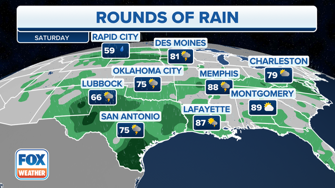
"On Friday, it's going to be towards Laredo and just to the west of I-35. Notice by Saturday, the weekend, the very likely threat of flooding starts to encompass the San Antonio Austin metro areas, and New Braunfels and all those spots that are in an extended and exceptional drought," Bender said. "But you're going to get too much rain at once."
Deep Gulf of Mexico moisture will be pulled north into the southern Plains, and there is a strong signal for potentially significant rainfall of several additional inches.
Multiple rounds of moderate to locally heavy rain are expected, raising concerns for flash flooding given increasingly saturated ground conditions.
Heavy rain and flash flooding continue to batter the central Plains.
WHY RARE 'HIGH RISK' FLOOD DAYS NEED TO BE TAKEN SERIOUSLY

(FOX Weather)
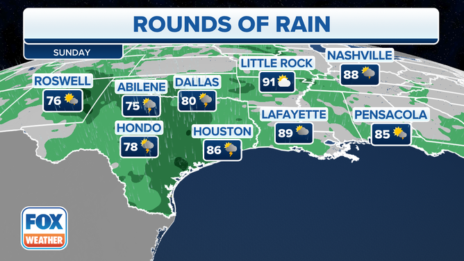
Rain continues through weekend
"So here's the good news. By Saturday, high pressure squeeze (will) this low pressure, start forcing it back towards the desert southwest. Now we're looking at the Four Corners region taking the brunt of the rain, but still getting some residual showers nestled in along the Gulf Coast," said Bender.
"And the reason why is because, yes, the high pressure oftentimes is more of a quiet weather pattern, but it's still going to bring in that moisture from the Gulf," he continued. "And so it's going to continue to pop along the plains and allow for that substantial rain to land in around Laredo and San Antonio for the next, really 72 hours.
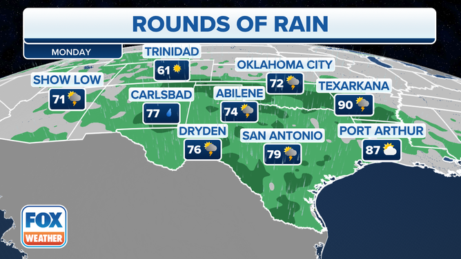
Residents in the Lower Mississippi Valley and southern Plains should keep umbrellas handy through at least Monday.
![]() Image 1 of 3
Image 1 of 3Saturday. ( )
![]() Image 2 of 3
Image 2 of 3Sunday. ( )
![]() Image 3 of 3
Image 3 of 3Monday. ( )