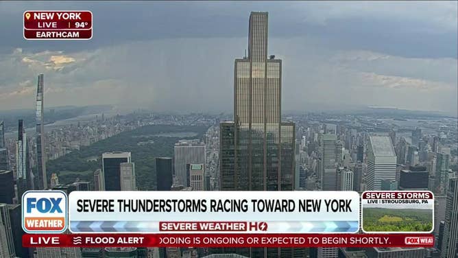
Severe storms rumble through Northeast heat dome with reports of damaging winds
According to the FOX Forecast Center, over 130 million people were under heat alerts while more than 40 million were under a Severe Thunderstorm Watch, which lasted into Friday evening.

Northeast transitions from a heat risk to a severe thunderstorm threat
After much of the region reached the mid to upper 90s on Friday, thunderstorms are now rolling through which are cooling down the region but also producing the threat of damaging winds.
NEW YORK – A dangerous heat wave blasted parts of the Northeast on Friday, sending "feels-like" temperatures well over 100 degrees and produced the risk for severe storms.
According to the FOX Forecast Center, over 130 million people were under heat alerts while more than 40 million were under a Severe Thunderstorm Watch, which lasted into Friday evening.
The primary threat from the storms was damaging wind gusts as they moved in from a general northwest to southeast direction.

Intense winds blow away umbrella at New Jersey golf course.
Video from Short Hills, New Jersey showed gusty winds blowing around debris and even dislodging an umbrella.
Several trees and power lines were reported down in Connecticut and Massachusetts, but power outages failed to top 10,000 across the New England region.
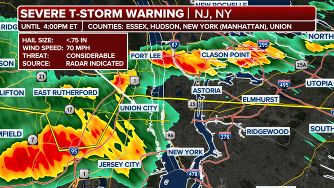
Included in the Severe Thunderstorm Watch were major cities such as New York, Philadelphia, Boston and Newark and Jersey City in New Jersey.
A Severe Thunderstorm Warning was issued for much of New York City and surrounding communities on Friday afternoon as a thunderstorm capable of producing rainfall amounts of more than 2" per hour and 70 mph wind gusts rumbled through.
Newark provided verification of that warning because the airport reported a wind gust to 63 mph, with an air temperature that dropped 25 degrees in less than half an hour.
More than 50,000 power outages were reported in Pennsylvania, New York and New Jersey.
![Severe Thunderstorm Warning issued for New York City.]() Image 1 of 3
Image 1 of 3Severe Thunderstorm Warning issued for New York City. ( )
![Severe Thunderstorm Warning issued for New York City.]() Image 2 of 3
Image 2 of 3Severe Thunderstorm Warning issued for New York City. ( )
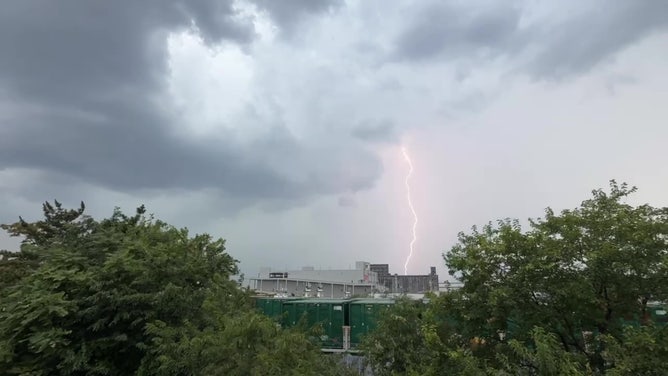
![Lightning in Brooklyn]() Image 3 of 3
Image 3 of 3A lightning strike in Brooklyn, New York on July 25, 2025. (Alex Hall)
Heat dome is warm but not a record-breaking heat wave
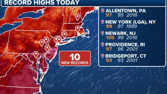
Many cities across the Northeast came within a few degrees of reaching their daily record high on Friday.
New York City's Central Park reached 94 degrees by early afternoon, with a feels-like temperature of 100. Boston was a degree warmer and "felt" like 102.
Philadelphia took the heat to the next level with even higher humidity levels scorching the City of Brotherly Love with a heat index of 108 degrees.
Newark was one of the cities that broke its record, reaching 100 degrees before the storms moved through.
High temperatures on 7/25/2025
(FOX Weather)
While afternoon highs were on the order of 5-10 degrees above average, overnight lows ventured on being 10-20 degrees above typical values.
Many cities from Washington, D.C. to New York started their day in the mid-to-upper 70s, which did not allow a break for buildings to cool off or air conditioning units to stop running.
Health experts have long stated that greater heat during the nighttime hours can lead to more heat stress on the body and lead to higher utility rates.

Protecting children from hot cars as temperatures soar
One of the most tragic consequences of extreme heat involves children and hot cars. Since 1998, over 1,000 children in the U.S. have died from heatstroke after being left in vehicles. This year alone, 16 children have already lost their lives this way, including a recent tragedy just this week in Alabama. To discuss ways to prevent these devastating incidents, FOX Weather is joined by Torine Creppy, president of Safe Kids Worldwide.
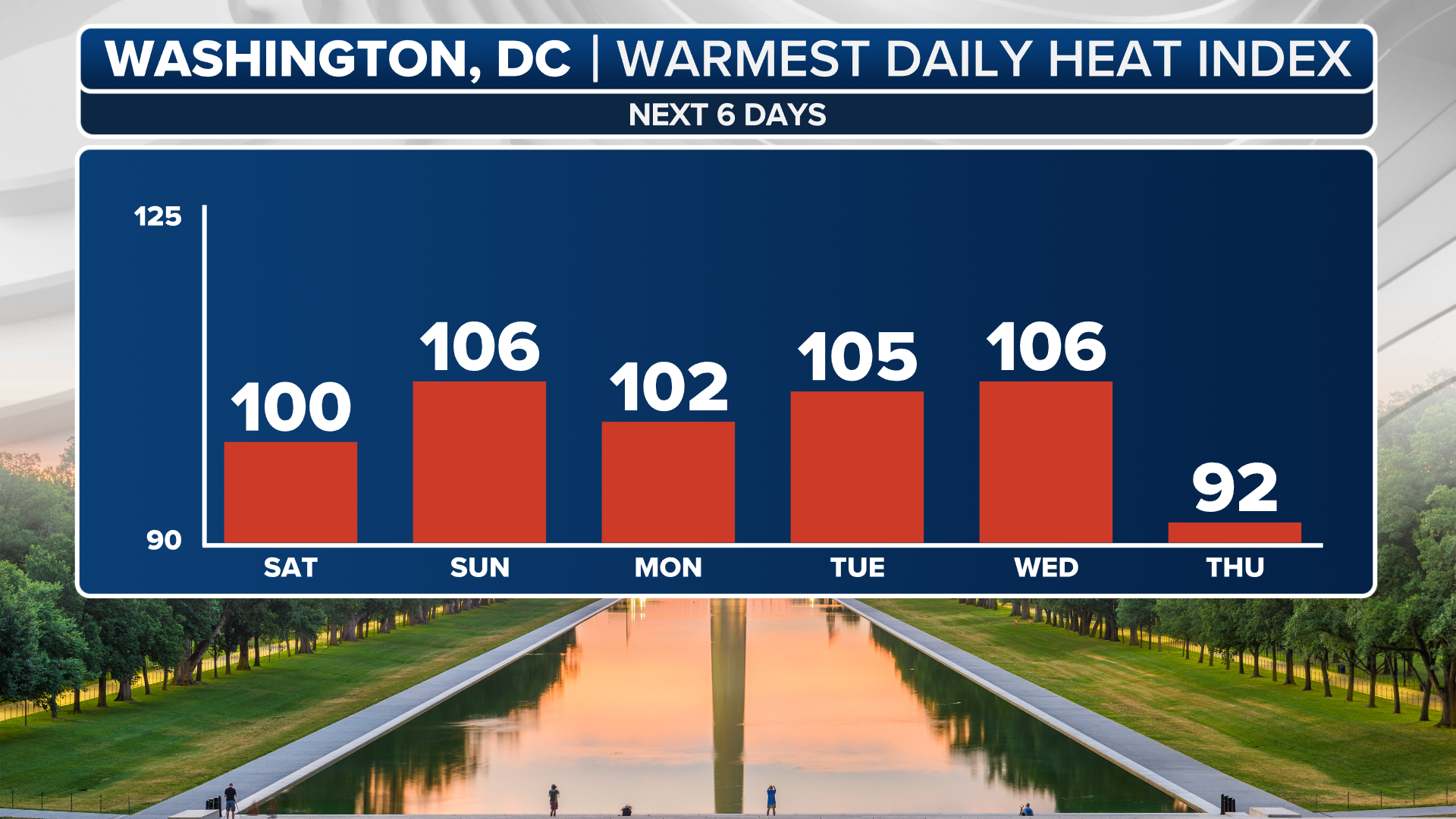
Relative cool down comes Saturday
By Saturday, slightly cooler temperatures are forecast for cities such as New York and Boston, where highs will dip back into the 80s. However, the mid-Atlantic will remain under the grip of extreme heat, with heat indices staying in the lower 100s from D.C. to Richmond, Virginia.
(FOX Weather)
So far this summer, more than two dozen U.S. cities are experiencing one of their top-five warmest summers on record, with temperatures averaging 1-3 degrees above normal, according to the FOX Forecast Center.
Long-range outlooks suggest the East and Northeast will likely remain warmer than average through the remainder of the season.