Tropical mischief south of Hawaii triggers gusty winds, Fire Weather Warnings for islands
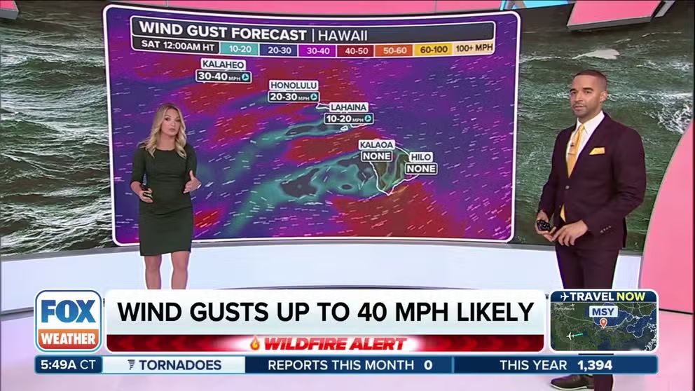
Wind gusts up to 40 mph remain likely Saturday along Oahu and Kauai, with gusts to 50 mph on Maui and the Big Island, especially in the leeward areas downwind of the islands' vast terrain.
Fire weather threat lingers across parts of Hawaii into Saturday
Dry, gusty winds will blow across the leeward areas of the Aloha State Saturday, where gusts to 40-50 mph could stoke any new fires.
HONOLULU– The parade of tropical activity south of Hawaii is ironically enhancing the risk of wildfires across the Aloha State into Saturday as gusty winds combine with dry conditions.
The remnants of Tropical Storm Iona and another former tropical system passing hundreds of miles south of the islands on Friday and Saturday, previously tagged as Invest 92C by the National Hurricane Center, were far enough away not to cause any direct impacts. But their low pressure centers, combined with a ridge of high pressure to the islands' northeast and temperature inversion hovering over the island, creates a recipe for moderately strong winds.
![Hawaii]() Image 1 of 4
Image 1 of 4Hawaii (Robert Ray)
![Hawaii]() Image 2 of 4
Image 2 of 4Hawaii (Robert Ray)
![Hawaii]() Image 3 of 4
Image 3 of 4Hawaii (Robert Ray)
![Hawaii]() Image 4 of 4
Image 4 of 4Hawaii (Robert Ray)


Wind gusts up to 35-40 mph are likely again Saturday along Oahu and Kauai, with gusts to 50 mph on Maui and the Big Island, especially in the leeward areas downwind of the islands' vast terrain.
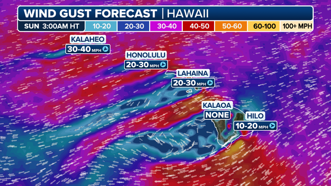
Hawaii Wind Gust Forecast
The winds will dry out as they blow down the mountain slopes, dropping relative humidity values into the 35-45% range in the afternoon, according to National Weather Service forecasts.
"A combination of strong winds, low relative humidity, and dry fuels can contribute to extreme fire behavior. Any fires that develop will likely spread rapidly," the National Weather Service in Honolulu said in issuing its Fire Weather Warning. The warning was later extended into Saturday evening.
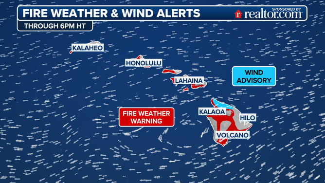
Hawaii Fire Weather Alerts
HOW TO WATCH FOX WEATHER ON TV
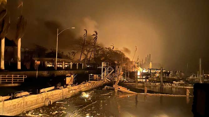
Thankfully, the setup is considerably weaker than the tropically-infused windstorm that triggered a devastating wildfire in Maui in August 2023 that killed 102 people. In that instance, winds were fueled by Category 4 Hurricane Dora that passed well south of the islands but triggered an intense pressure gradient.
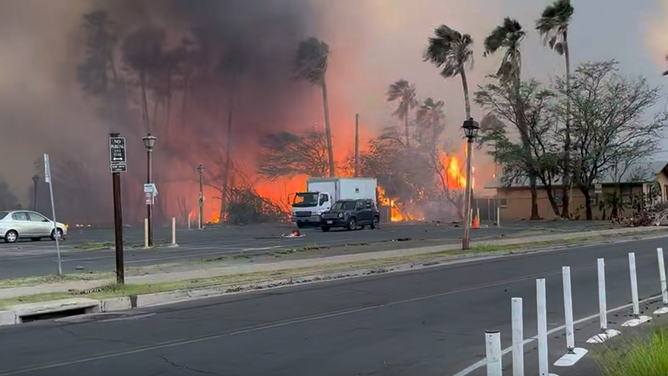
![A charred dock near Lahaina in Maui where U.S. National Guard Hawaii Pacific crews continue rescue operations from fires in Hawaii on Aug. 10, 2023. (]() Image 1 of 15
Image 1 of 15Flames roar near a dock in Lahaina where U.S. National Guard Hawaii Pacific crews continue rescue operations from fires in Hawaii on Aug. 10, 2023. (Image: USGS Hawaii Pacific/Twitter) (USGS)
![A man on a bike carries a cross in the north side of Lahaina, Hawaii, on August 16, 2023.]() Image 2 of 15
Image 2 of 15A man on a bike carries a cross in the north side of Lahaina, Hawaii, on August 16, 2023. (PATRICK T. FALLON/AFP )
![]() Image 3 of 15
Image 3 of 15(Robert Ray)
![Firefighters in Maui were busy battling wildfires and structure fires in Lahaina along the main tourist drag of Front Street. Alan Dickar said he captured video in the afternoon full sun, but the thick smoke blocked out the clear, blue sky.]() Image 4 of 15
Image 4 of 15Firefighters in Maui were busy battling wildfires and structure fires in Lahaina along the main tourist drag of Front Street. Alan Dickar said he captured video in the afternoon full sun, but the thick smoke blocked out the clear, blue sky. (Alan Dickar/Facebook)
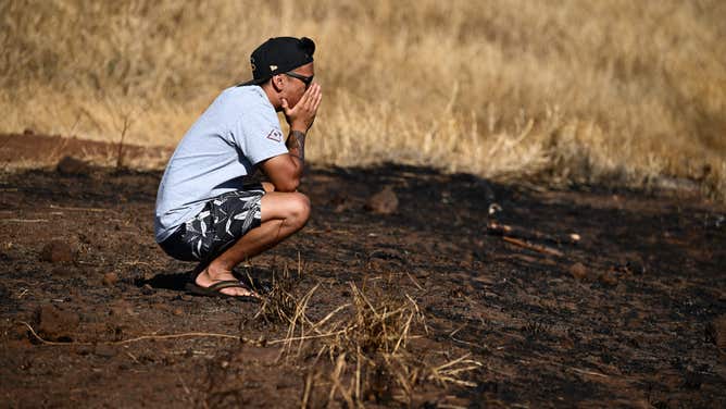
![Maui resident John Rey Serrano reacts while looking from a road above Lahaina Town in the aftermath of a wildfire in Lahaina, western Maui, Hawaii on August 11, 2023. A wildfire that left Lahaina in charred ruins has killed at least 67 people, authorities said on August 11, making it one of the deadliest disasters in the US state's history. Brushfires on Maui, fueled by high winds from Hurricane Dora passing to the south of Hawaii, broke out August 8 and rapidly engulfed Lahaina. (Photo by Patrick T. Fallon / AFP) (Photo by PATRICK T. FALLON/AFP via Getty Images)]() Image 5 of 15
Image 5 of 15Maui resident John Rey Serrano reacts while looking from a road above Lahaina Town in the aftermath of a wildfire in Lahaina, western Maui, Hawaii on August 11, 2023. (Patrick T. Fallon / AFP)
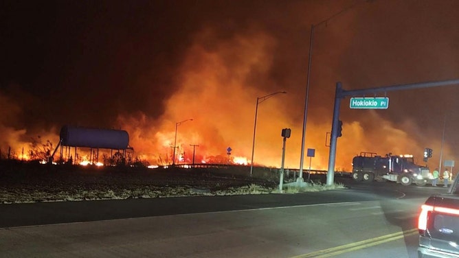
![The intersection at Hokiokio Place and Lahaina Bypass is seen Tuesday evening, August 8, 2023, as wildfires burn in Maui County, Hawaii.]() Image 6 of 15
Image 6 of 15The intersection at Hokiokio Place and Lahaina Bypass is seen Tuesday evening, August 8, 2023, as wildfires burn in Maui County, Hawaii. (Maui County)
![A large amount of destruction is visible in Lahaina town after deadly wildfires ravaged parts of Maui island in Hawaii.]() Image 7 of 15
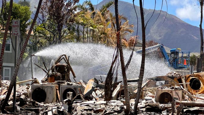
Image 7 of 15A large amount of destruction is visible in Lahaina town after deadly wildfires ravaged parts of Maui island in Hawaii. (Robert Ray)
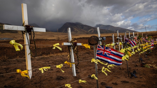
![People gather at a public hillside memorial to Lahaina wildfire victims on August 7, 2024 in Lahaina, Hawaii.]() Image 8 of 15
Image 8 of 15People gather at a public hillside memorial to Lahaina wildfire victims on August 7, 2024 in Lahaina, Hawaii. August 8 marks the one-year anniversary of the Maui wildfires which killed 102 people and devastated the historic community of Lahaina in West Maui. (Photo by Mario Tama/Getty Images) ( )
![Brush fire burning buildings in Lahaina, Hawaii]() Image 9 of 15
Image 9 of 15Brush fire burning buildings in Lahaina, Hawaii (Jeff Melichar/LOCAL NEWS X /TMX )
![LAHAINA, HAWAII - AUGUST 29, 2023 - A makeshift memorial honoring the victims killed in the Aug. 8 fires and those who remain missing is seen in Lahaina, HI, on Aug. 29, 2023. (Photo by Tamir Kalifa for The Washington Post via Getty Images)]() Image 10 of 15
Image 10 of 15A makeshift memorial honoring the victims killed in the Aug. 8 fires and those who remain missing is seen in Lahaina, HI, on Aug. 29, 2023. (Tamir Kalifa for The Washington Post)
![An aerial image taken on August 10, 2023 shows a person walking down Front Street past destroyed buildings burned to the ground in Lahaina in the aftermath of wildfires in western Maui, Hawaii.]() Image 11 of 15
Image 11 of 15An aerial image taken on August 10, 2023 shows a person walking down Front Street past destroyed buildings burned to the ground in Lahaina in the aftermath of wildfires in western Maui, Hawaii. ( )
![TOPSHOT - A Mercy Worldwide volunteer makes damage assessment of charred apartment complex in the aftermath of a wildfire in Lahaina, western Maui, Hawaii on August 12, 2023. Hawaii's Attorney General, Anne Lopez, said August 11, she was opening a probe into the handling of devastating wildfires that killed at least 80 people in the state this week, as criticism grows of the official response. The announcement and increased death toll came as residents of Lahaina were allowed back into the town for the first time.]() Image 12 of 15
Image 12 of 15TOPSHOT - A Mercy Worldwide volunteer makes damage assessment of charred apartment complex in the aftermath of a wildfire in Lahaina, western Maui, Hawaii on August 12, 2023. Hawaii's Attorney General, Anne Lopez, said August 11, she was opening a probe into the handling of devastating wildfires that killed at least 80 people in the state this week, as criticism grows of the official response. The announcement and increased death toll came as residents of Lahaina were allowed back into the town for the first time. (Yuki IWAMURA / AFP)
![An ambulance stops at a National Guard post in the aftermath of a wildfire in Lahaina, western Maui, Hawaii on August 16, 2023.]() Image 13 of 15
Image 13 of 15An ambulance stops at a National Guard post in the aftermath of a wildfire in Lahaina, western Maui, Hawaii on August 16, 2023. (PATRICK T. FALLON/AFP)
![]() Image 14 of 15
Image 14 of 15Charred remains of a burned neighbourhood is seen in the aftermath of a wildfire, in Lahaina, western Maui, Hawaii on August 14, 2023. (YUKI IWAMURA/AFP)
![A large amount of destruction is visible in Lahaina town after deadly wildfires ravaged parts of Maui island in Hawaii.]() Image 15 of 15
Image 15 of 15A large amount of destruction is visible in Lahaina town after deadly wildfires ravaged parts of Maui island in Hawaii. (Robert Ray)


Winds will gradually decrease from Sunday into Tuesday as the pressure differences relax and Iona and the former-92C move even farther away, getting the islands back to typical early summer weather.
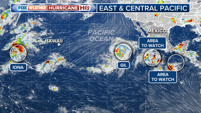
Eastern Pacific Tropics Overview
(FOX Weather)
What will Gil do?
Forecasters are then keeping an eye on Hurricane Gil, which is currently churning well southeast of the islands in the very busy eastern Pacific Ocean. Forecast models indicate Gil will cling to hurricane status through Saturday, then begin to weaken as it heads west/northwest into early next week in the general direction of Hawaii.
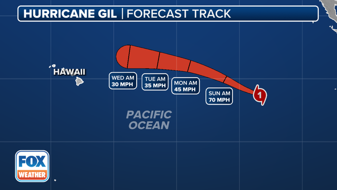
Hurricane Gil Forecast Cone
TROPICAL STORM GIL STRENGTHENS IN BUSY PACIFIC BASIN
However, the relatively cool ocean waters surrounding Hawaii would prevent Gil from maintaining any kind of significant tropical potency if it approached the islands, and current projections from the NHC show Gil would have weakened to a tropical depression or less long before it reached the state. However, Gil's remnants could bring some rain to the state if the system tracks close enough.
Behind Gil, there are two other areas the NHC has tagged as areas to watch for future tropical development, with the western one expected to reach at least tropical depression status by the end of the weekend, but it's too early to know their ultimate fate.