Caribbean disturbance ‘98L’ could spell tropical trouble for Gulf of Mexico, Florida next week
The FOX Forecast Center is closely watching Invest 98L as it moves through the Caribbean this week. It has a high chance of development in the coming days.
Development chances increase for Caribbean disturbance
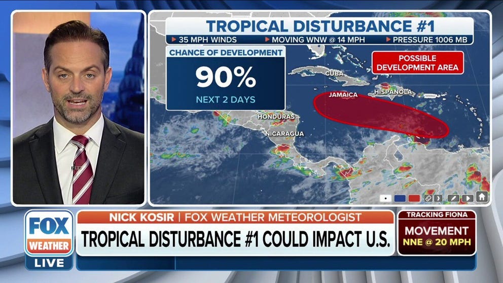
In the latest advisory, The National Hurricane Center says a tropical disturbance in the Caribbean Sea now has a 90% chance of development in the next two days.
Meteorologists at the FOX Forecast Center are closely monitoring a tropical disturbance near South America, which has a high likelihood of developing into a stronger system in the coming days.
FOX Weather has named this system Disturbance 1. The National Hurricane Center has designated the disturbance as Invest 98L. "Invest" is a moniker used by the NHC to identify an area of weather that is being investigated for possible development into at least a tropical depression within the next several days.

(FOX Weather)
Hurricane Hunters have been flying missions into Invest 98L since Wednesday. The data collected by these flights are crucial to helping refine tropical-weather forecasts.
Once the disturbance gains a center of circulation and has sustained winds of at least 38 mph or less, it is classified as a tropical depression. Once it has winds of 39-73 mph, it is called a tropical storm and will receive a name.
Here’s everything you need to know about Invest 98L, which FOX Weather has dubbed Disturbance 1.
Where is Invest 98L now?
As of Thursday evening, Invest 98L had developed into an area of low pressure and was located in the southeastern Caribbean Sea. It was just north of the Venezuelan coast.
It has been producing stormy weather across parts of the Windward Islands, as well as northern Venezuela and the so-called ABC island chain of Aruba, Bonaire and Curaçao.
7 FACTS TO KNOW ABOUT HURRICANES

(FOX Weather)
Where is Invest 98L headed?
In the short term, Invest 98L is in the southeastern Caribbean, and producing heavy rain, gusty winds and rough seas across northern Venezuela and the ABC island chain of Aruba, Bonaire and Curaçao.
It's likely that a tropical depression forms in the next couple of days as the disturbance continues its trek through the Caribbean.
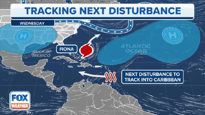
Next week is when forecast models want to bring the system closer to the mainland U.S., where both the Gulf of Mexico region and the Florida Peninsula have possibilities of being affected.
HOW TO PREPARE FOR HURRICANE SEASON

(FOX Weather)
It is too early to say with any certainty where Invest 98L is headed next week. Several factors will play a role in determining the ultimate destination of the system, including the speed at which it develops and the position of the jet stream. Anyone with interests along the Gulf Coast or Florida should pay close attention to the forecast.
(FOX Weather)
What’s working against Invest 98L?
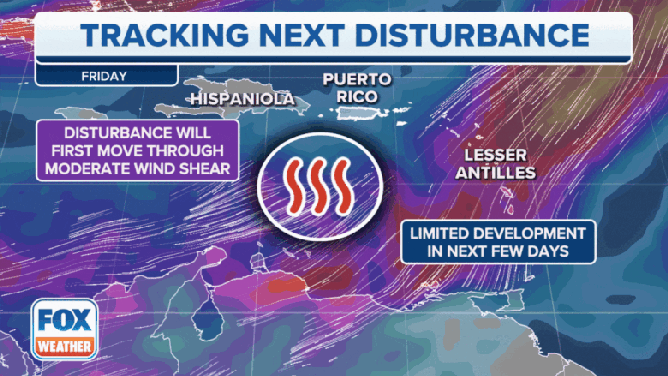
Invest 98L is facing a rather tough environment for much development through Friday thanks to Category 4 Hurricane Fiona which is moving toward Bermuda.
Upper-level winds from Fiona are creating lots of wind shear – winds that change direction and speed at various heights – which is keeping thunderstorms associated with the disturbance from growing. That is expected to continue through at least Friday.
(FOX Weather)
What’s helping Invest 98L develop?
Beyond Friday, Invest 98L is expected to move into the Caribbean Sea and an environment much more suited to the development of tropical systems.
Wind shear is expected to be much lower in this region this weekend.
Water temperatures in this part of the ocean are in the upper 80s, which is a couple of degrees above average, providing ample fuel for development.

(FOX Weather)
Bottom line
Invest 98L is forecast to move through the Caribbean Sea this weekend, where it is expected to strengthen. It could become a tropical depression or tropical storm within the next couple of days. It is too soon to say with any certainty how strong the system could become.
WHAT’S THE DIFFERENCE BETWEEN A TROPICAL DEPRESSION, TROPICAL STORM AND HURRICANE?
Long-range forecast models suggest the disturbance could pose a threat to areas along the Gulf Coast and Florida Peninsula in the U.S. late next week. It is too early to say for certain where it is headed next week. Anyone living in those areas should pay close attention to the forecast.