Bryan Norcross Hurricane Q&A focuses on AI forecasting capabilities
During the first four months of the hurricane season, nine named storms formed, including four hurricanes. Three hurricanes reached major status with winds of at least 115 mph, which is equivalent to a Category 3 on the Saffir Simpson Hurricane Wind Scale.

Tracking future tropical development in the Atlantic
The National Hurricane Center is monitoring two new areas to watch in the Atlantic, keeping hurricane season alive and active. Right now, both areas are tagged with low development odds.
New this hurricane season, scientists are leveraging artificial intelligence to improve the accuracy of tropical cyclone forecasts.
FOX Weather Hurricane Specialist Bryan Norcross spoke with Ferran Alet, a research scientist who works with Google DeepMind, about how these powerful computer systems are transforming the way meteorologists predict tropical cyclones.
Alet stated that unlike with conventional models that rely on extensive supercomputers and deterministic outputs, the AI approach generates multiple potential future scenarios in a fraction of the time.
"It used to take a supercomputer multiple hours to run a forecast. And now with AI, you do it...in about a minute to generate one of these forecasts," Alet stated.
WHAT TO EXPECT FOR FINAL 2 MONTHS OF ATLANTIC HURRICANE SEASON
During the FOX Weather livestream discussion, the experts examined recent tropical weather activity, including Hurricane Imelda, which recently impacted Bermuda and is racing toward Northern Europe.
The AI model’s initial forecasts indicated a high likelihood of Imelda moving offshore the Southeast, which aligned with later advisories.
Since storms like Imelda often begin as weak disturbances, operators wait until the National Hurricane Center designates a system as an invest area before tracking and analyzing its potential development.
Norcross and Alet also discussed potential enhancements which could help refine forecasts, aiding emergency managers and the public in making informed decisions ahead of a threat from a tropical system.
The first storm of the season formed on June 23, and since Andrea, eight additional storms have formed.
Tropical Storm Chantal, in early July, has been the only cyclone to make landfall in the U.S.
Despite hurricanes Erin and Imelda being hundreds of miles off the coastline, coastal flooding and erosion have been significant along the North Carolina coast.
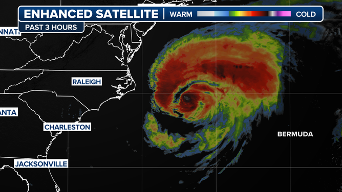
Satellite view of Hurricane Erin off the U.S. East Coast on Aug. 21, 2025.
(FOX Weather)
HURRICANE HUNTERS FLY INTO WORLD’S WORST WEATHER. SEE WHICH STORM WAS THE BUMPIEST
Norcross said that in Imelda's wake, the National Hurricane Center is monitoring two additional areas of disturbed weather, but neither are showing signs of immediate development.
One disturbance is located off the coast of the Sunshine State, while the other has yet to exit the coast of Africa.
Even without further organization, the feature near Florida will help to produce heavy rainfall and rough surf conditions into next week.
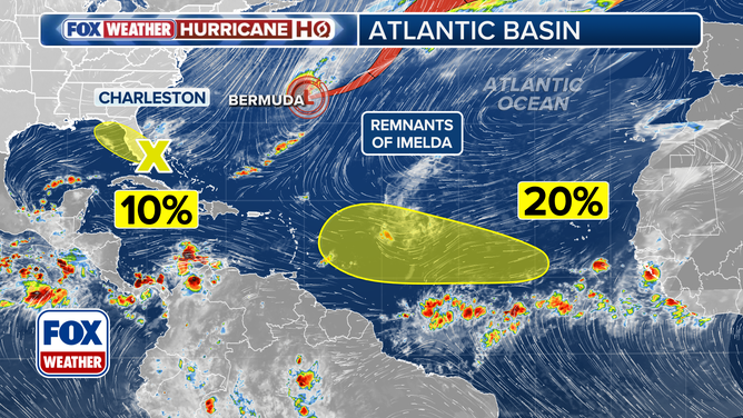
Atlantic tropics overview for Oct. 2, 2025.
(FOX Weather)
AI models for the wave along the African coast have been rather steadfast, with many showing the disturbance recurving well east of the U.S. and maybe even the Caribbean islands, but forecasters caution there is still a long way to go.
Whichever system develops first will become known as Jerry – the tenth named system of the season.
During an average season, 14 named tropical storms form, with around half of those strengthening into at least Category 1 hurricanes.
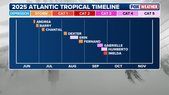
2025 hurricane season timeline
(FOX Weather)