Southeast coast braces for wind, rain and flooding from possible tropical system
The area of disturbed weather will likely drop several inches of rain from Florida to the Carolinas and into the mid-Atlantic and New England states, accompanied by gusty winds that could produce large waves, dangerous rip currents and coastal flooding.
Heavy rain and high surf for the Atlantic coast through the weeknd
The heavy rain Florida has been enduring this week is on the move. Meteorologist Steve Bender explains how much rain and times out the storm from Florida to New England.
MIAMI – There won’t be much sunshine in the Sunshine State this week as a stationary front remains parked over Florida, sparking numerous chances of heavy rain and thunderstorms through the rest of the week, and forecasters are also keeping their eye on possible tropical development off the southeastern coast of the U.S.
Regardless of tropical development at the end of the week, the area of disturbed weather will likely drop several inches of rain from Florida to the Carolinas and into the mid-Atlantic states, accompanied by gusty winds that could produce large waves, dangerous rip currents and coastal flooding.
Florida weather to remain rainy, stormy this week
Rain pushes north along the I-95 corridor.
(FOX Weather)
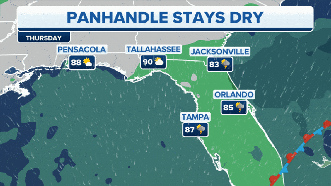
With the front stalled over Florida, there will be a risk of thunderstorms that could produce heavy rain, gusty winds and frequent lightning.
And while the chances of showers and thunderstorms will be higher from the Orlando area and points south, most of the activity will be prevalent across South Florida and along areas where sea breeze boundaries along the Atlantic coast set up during the day.
HERE'S WHEN THE SUNSHINE STATE'S RAINY SEASON GETS UNDERWAY
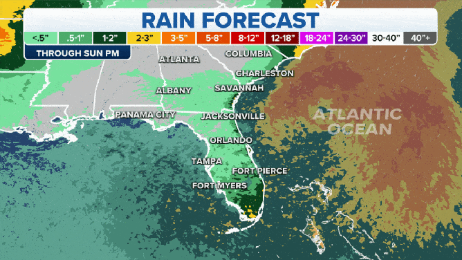
Rain totals through the weekend.
(FOX Weather)
Inland areas of the state could pick up 1 to 2 inches of rain through the rest of the week and into the weekend. However, higher totals between 2 and 3 inches and locally higher amounts are possible in places like West Palm Beach, Fort Lauderdale and Miami.
Farther north along the coast, areas like Vero Beach, Fort Pierce and Melbourne can also expect to see a few inches of rain this week.
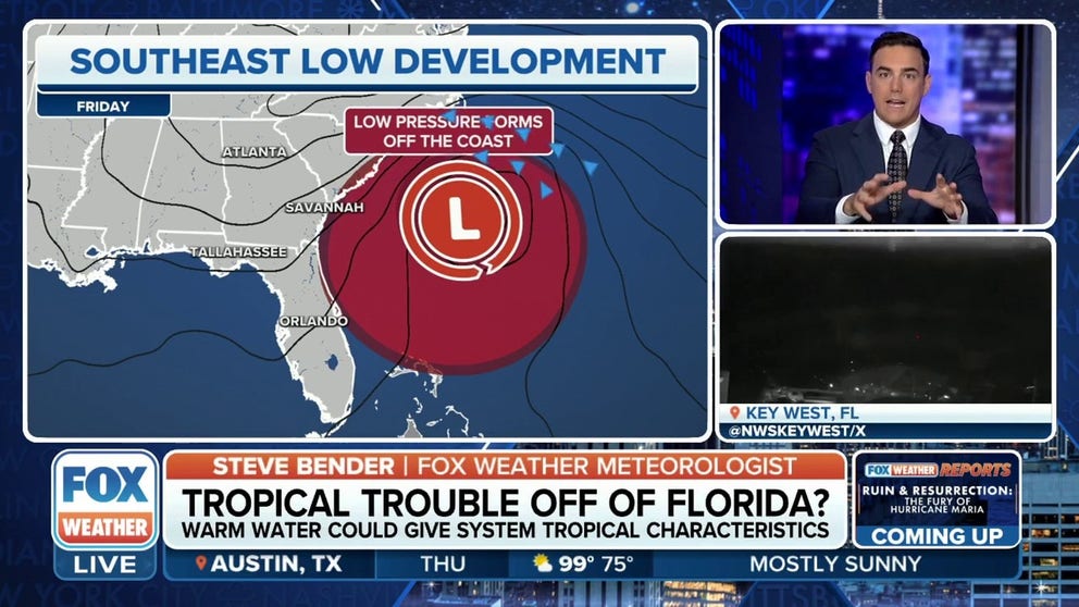
By Friday, there could be another issue that residents in the Southeast will need to keep an eye on – possible tropical development off the coast.
Tropical trouble could be brewing off Southeast coast

(FOX Weather)
"Thunderstorms that are lurking off the east coast of Florida could come together in our next area to watch," FOX Weather meteorologist Jane Minar said.
Thunderstorm activity over the warm waters of the Atlantic Ocean could be some of the fuel it needs to develop into a tropical system, but there won’t be much time for it to get its act together and develop.
"This is going to happen either Friday or Saturday," Minar continued. "The timeline is very short here, if it happens at all."
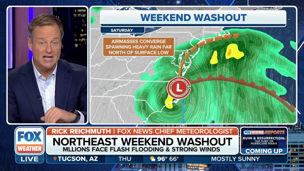
Weekend washout for I-95 corridor
The storm that could become a tropical depression will head north and soak the mid-Atlantic and Northeast into the weekend. Here is the forecast.
Regardless of what happens, the weather won’t be ideal in coastal areas from Florida to the Carolinas and into the mid-Atlantic states.
The National Hurricane Center (NHC) said the system now has a medium chance of development.
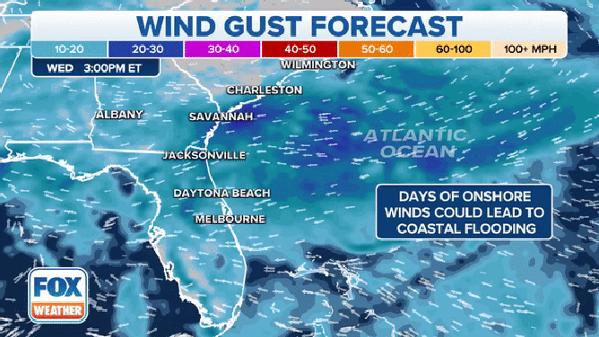
Strong winds coming off the ocean could lead to coastal flooding from Florida to the mid-Atlantic.
(FOX Weather)
"We could see flooding rains, gusty winds, and we have this consistent onshore push of wind over the next several days," Minar said.
With that onshore push of wind, areas along the coast should make preparations for coastal flooding.

High tide flooding in Charleston
Seawater flowed through downtown Charleston on Sunday during high tide. Strong onshore winds are piling water at the shore.
Charleston, South Carolina, for example, already had several days of soggy weather and coastal flooding over the weekend.
"You might see a little bit more water push in with those tides, especially with that onshore push of water," Minar said. "But the system continues up the coast."
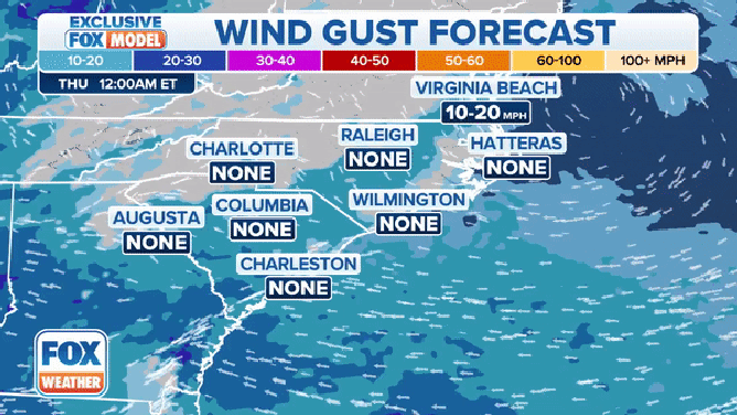
The wind gust forecast through Sunday, September 24, 2023.
(FOX Weather)
Winds will be whipping along the coast, with places like Hatteras, North Carolina, potentially seeing wind gusts approaching hurricane force.
Elsewhere, winds are expected to gust anywhere from 40 to 50 mph across the region.

(FOX Weather)
Several inches of rain is also forecast to fall along the east coast from the Carolinas to the mid-Atlantic. The highest rain totals will be found closer to the coast, where 3 to 5 inches of rain could fall from North Carolina into Virginia, Maryland and Delaware.
Locally higher amounts are also possible along North Carolina's Outer Banks.
Storm could have Northeast, New England bracing for more heavy rain, gusty winds
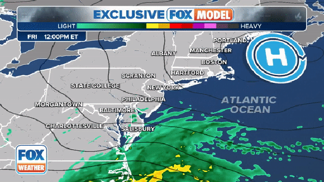
The exclusive FOX Model showing the progression of a low pressure system moving up the East Coast this weekend.
(FOX Weather)
The low-pressure system will be making its trek up the East Coast over the weekend and will likely be impacting the Northeast and New England – two places that don’t need the extra rain.
Communities across the region are seeing a surplus in precipitation, and more rain will only add to the already-saturated ground.
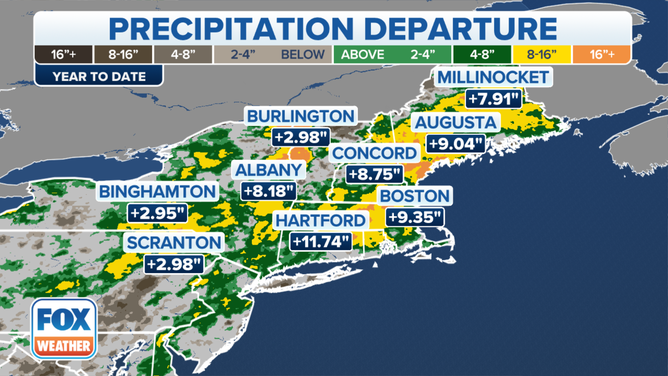
An image showing several areas in the Northeast and New England seeing rain totals that are above average for this time of year.
(FOX Weather)
Hartford, Connecticut, for example, is almost a foot above average in terms of precipitation totals for this time of year, and Boston is nearly 10 inches above average.
Between 2 and 3 inches of rain is expected from central New Jersey through southern New England, including Providence, Rhode Island, and Boston, with lower amounts expected farther from the coast.
Parts of southern New Jersey, Delaware and Maryland could see totals between 3 and 5 inches.

(FOX Weather)
And while high rain totals may not reach central and northern New England, coastal areas could see a few inches of additional rain.
Winds, too, will be strong.
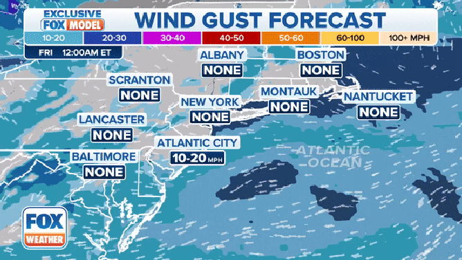
Forecast wind gusts in the Northeast and New England this weekend.
(FOX Weather)
By Saturday afternoon, winds along coastal areas in the Northeast and New England could be gusting to tropical storm force.
From Atlantic City, New Jersey, to New York City and Montauk, New York, winds on Saturday afternoon could be gusting to between 40 and 50 mph.
Inland, the winds could be a bit higher, with places like Lancaster, Pennsylvania, seeing gusts to between 50 and 60 mph.