Desert Southwest braces for heavy rain, potential dangerous flash floods from dual tropical remnants
Flood Watches are in effect across a large swath of the Southwest and include cities like Phoenix and Flagstaff in Arizona, as well as Grand Canyon National Park as moisture streams in first from the remnants of Tropical Storm Priscilla, then later from Tropical Storm Raymond next week.

Southwest braces for heavy rainfall as dangerous flash flood threat looms
The remnants of what was once Hurricane Priscilla in the Eastern Pacific, in combination with other ingredients, are making for a wet, and potentially dangerous, weekend across portions of the Southwest. FOX 10 Phoenix Meteorologist Krystal Ortiz joined FOX Weather to discuss the heavy rain forecast set to soak Arizona and portions of the Southwest on Oct. 10, 2025.
PHOENIX – The Desert Southwest is bracing for heavy rain as threats of dangerous flash flooding loom due to tropical moisture from the remnants of what was once Hurricane Priscilla.
Rainfall is expected to continue through the weekend as the initial wave of tropical moisture will be followed by Tropical Storm Raymond brewing in the Eastern Pacific, setting the stage for a wet weekend into Tuesday across portions of the Southwest. Flood Watches have been issued in areas in Arizona, Utah and California and include cities like Phoenix and Flagstaff in Arizona, as well as Grand Canyon National Park.
The multiple influxes of tropical moisture has resulted in a level 2 out of 4 flash flood risk across western Arizona, southern California, southern Nevada, and southwestern Utah through Friday as the storms begin to erupt. In parts of Arizona and Utah, level 3 out of 4 flash floods have been issued where the heaviest rainfall will occur.

(FOX Weather)
Computer forecast models show coverage and intensity of the precipitation is expected to increase as we approach and enter into the upcoming weekend, which is leading to fears of flash flooding through at least the start of next week.
The foothill and mountain areas north and east of Phoenix appear to be in the greatest threat zone, with the terrain helping to intensify the rainfall rates.
FOX 10 Phoenix Meteorologist Krystal Ortiz joined FOX Weather on Friday ahead of the arrival of the heaviest rain in Phoenix.
"Now most of the rain is in northern Arizona, but we are prepping for what we expect to be the heaviest rain late this afternoon, overnight and early tomorrow morning, so we definitely have more to come," Ortiz said.
DOWNLOAD THE FREE FOX WEATHER APP

(FOX Weather)
According to the FOX Forecast Center, widespread downpours and a few storms are likely throughout Friday with rain rates reaching 1 to 2 inches per hour, which could lead to dangerous flash flooding.
As the weekend progresses, an even larger flash flood warning zone is present Saturday as the moisture slowly shifts east, with Flood Watches being issued across southeastern California, most of Arizona and southern Utah through Saturday, according to the FOX Forecast Center. Flood risks shift farther south into southeastern Arizona and southwestern New Mexico on Sunday.
"Excessive rainfall may result in flooding of slot canyons, normally dry washes, slickrock areas, recent burn scars and other low-lying and flood-prone locations," National Weather Service staff warned.
The rainfall is not associated with the annual monsoon, which officially ended last month, and is instead being driven by tropical moisture from the Pacific and energy from a dip in the jet stream farther north.

(FOX Weather)
Looking at the main areas of concern ahead of the heavy rainfall, Ortiz paid specific attention to Globe and Miami in Gila County, Arizona.
"The other main spot that we're really watching around Arizona is Globe-Miami, because they're still in full clean-up mode from the mess of flooding they had only two weeks ago, and they do look like they could be in one of the bullseye zones for heavy rain throughout tomorrow," Ortiz said Friday. "Especially if we get some of those stronger thunderstorms were expecting, in that area the forecast is about 2 to 3 inches of additional rain that is possible and that unfortunately that is probably more than some of the creeks and rivers there can handle."
ARIZONA FLASH FLOODING LEAVES AT LEAST 4 DEAD AS 1,000 PROPANE TANKS GET SWEPT DOWNSTREAM
According to forecasters, just 6 inches of fast-moving water can knock an adult off their feet, and a foot of floodwater can carry a car away.
In addition to the dangers, the prolonged wet weather event will have two primary benefits: drought relief and cooler temperatures.
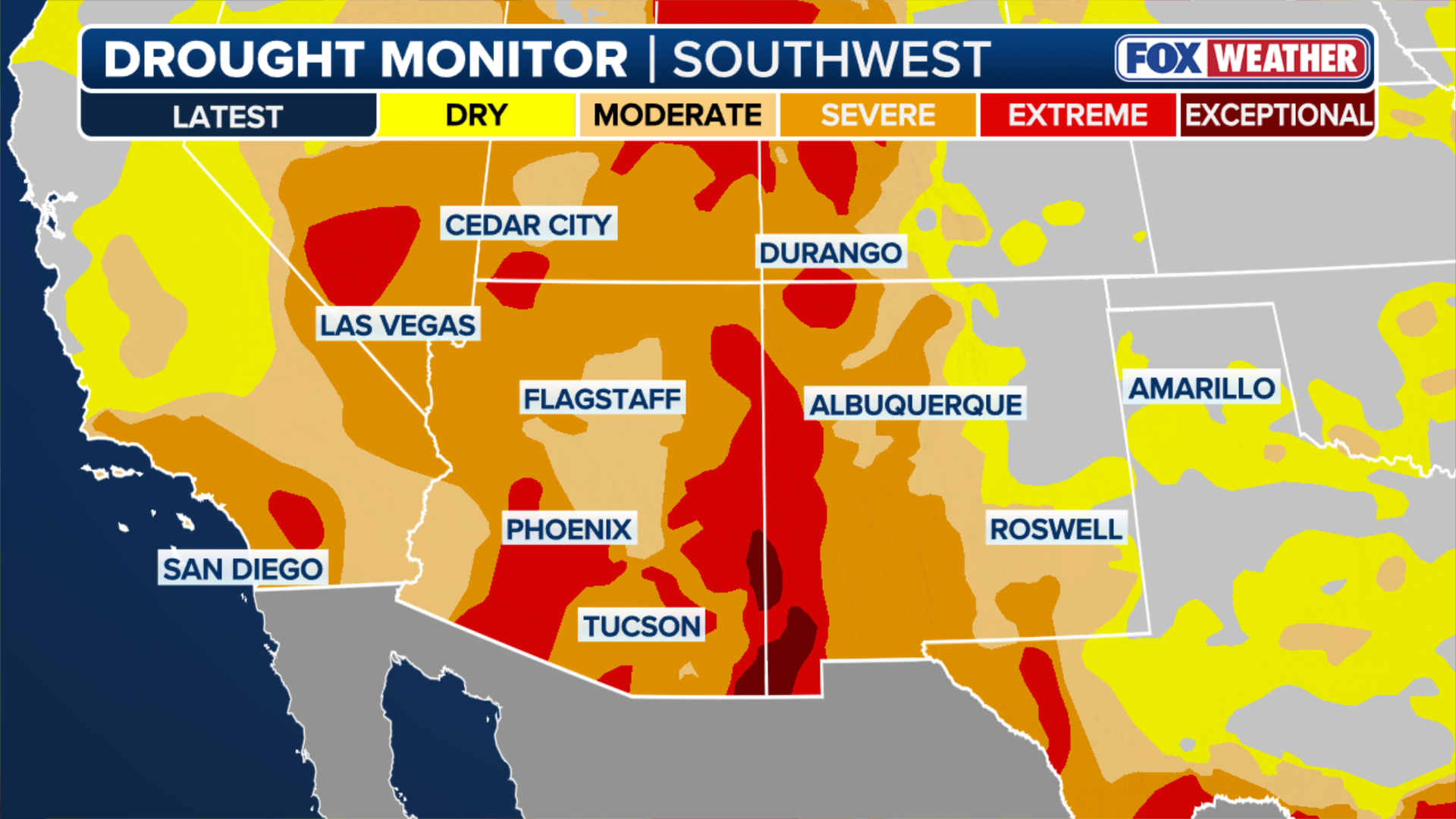
More than 80% of the western U.S. is facing unusually dry conditions, with some communities officially in "exceptional drought" status – the most intense level of drought. At this stage, communities typically face widespread crop losses, water shortages and significant wildfire risks.
With all the rainfall, the fire risk level is expected to drop along with temperatures.
For parts of Arizona, the amount of rainfall forecast through Tuesday is above average for the entire month of October. While the heavy rain forecast for a short period of time elevates the risk of flash flooding, most of the region remains in drought, with locations like Flagstaff and Tuscon 4 inches below average for rainfall this year.
(FOX Weather)
Tropical Storm Raymond moisture to bring more rain next week
Tropical moisture stemming from Tropical Storm Raymond will continue to soak the Southwest into next week and introduce yet another heavy round of rainfall and flash flooding on Monday and Tuesday.
A widespread possible chance of 2 to 3 inches of rain is forecast across Arizona on Tuesday, with locations across central and southern Arizona potentially seeing 3 to 5 inches of rain, and localized areas seeing over 5 inches of rain.