Los Angeles, San Diego under State of Emergency as atmospheric river lashes Southern California
A dangerous atmospheric river storm is blasting California with widespread impacts from heavy rain, damaging winds and potentially life-threatening flash flooding.
Heavy rain, snow and high winds headed for Los Angeles
FOX Weather continues to track a dangerous atmospheric river-fueled storm. Northern California is cleaning up downed trees while Southern California is bracing for the worst.
FOX Weather's continued coverage of the deadly atmospheric river hitting California on Monday has moved to this link.
LOS ANGELES – A dangerous atmospheric river storm is blasting California with widespread impacts from heavy rains, damaging winds and potentially life-threatening flash flooding.
Forecasters have highlighted Southern California, including downtown Los Angeles, for a rare "high risk" of flash flooding as the storm has already dumped several inches of rain across the region Sunday with more to come Monday. California Gov. Gavin Newsom even declared a State of Emergency for several counties in Southern California to support storm response and recovery efforts.
The "high risk" is the highest rung on NOAA's flash flood threat scale and is only issued under the most dire of flooding forecasts. "Life-threatening flash and urban flash flooding possible in the high risk area," NOAA's Weather Prediction Center (WPC) said.
![]() Image 1 of 7
Image 1 of 7Firefighters assist evacuating 4 adults and a dog from the red tagged units. Take a look at the tree on the right that fell through the roof. (@SBCFireInfo/X)
![]() Image 2 of 7
Image 2 of 7Rain weighed down the leaves and branches of a tree in Bodega, Bay California. The tree split and fell on two separate homes. (Sonoma County Fire District)
![]() Image 3 of 7
Image 3 of 7A dangerous situation in Arroyo Grande, California after storm winds knocked trees into powerlines, stripping the poles. (San Luis Obispo County Office of Emergency Services)
![]() Image 4 of 7
Image 4 of 7Downed trees closed the Pacific Coast Highway through Carmel Valley, California Sunday. (Caltrans)
![]() Image 5 of 7
Image 5 of 7Heavy snow closed Ebbetts Pass. Caltrans posted that travel is discouraged around the Tahoe, California area unless absolutely necessary. (Caltrans)
![]() Image 6 of 7
Image 6 of 7Crews stop vehicles through mountain roads near Tahoe, California on Sunday as feet of snow come down. (CHP Truckee)
![]() Image 7 of 7
Image 7 of 7Oregon State Police caught this near miss accident on dash cam. Crews were assisting a disabled vehicle on the side of the road when a car with balding tires slid on rain-slicked roads, according to police. After hitting the slope, the car overturned. No one was hurt. (Oregon State Police)


Flash Flood Warnings covered nearly 11 million people in the greater Los Angeles area through Sunday night.
The storm hasn't spared the northern and central sections of the state either, with torrential rain and wind gusts climbing over 70 mph. Nearly 900,000 customers were without power across California as of late Sunday evening.
WHY RARE ‘HIGH RISK’ FLOOD DAYS NEED TO BE TAKEN SERIOUSLY

(FOX Weather)
The Golden State mobilized and prepositioned a record 8,500 emergency responders ready for flooding, landslide and travel emergencies, according to the Governor's office. The State of Emergency included Los Angeles, Orange, Riverside, San Bernardino, San Diego, San Luis Obispo and Ventura Counties.
In Santa Barbara, the swollen Mission Creek forced police to evacuate residents along streets near the downtown corridor.
The National Weather Service office in Los Angeles continues to use strong language in its forecasts, indicating a significant threat of widespread and dangerous flash flooding through Monday. Forecasters warned that flooding issues would not be confined to the usually prone areas in the foothills, mountains and burn areas and that numerous mudslides and debris flows are expected.
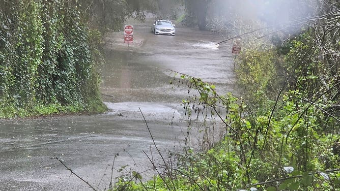
A car trying to drive through a flooded street in Santa Cruz County, California due to heavy overnight and Sunday rain.
(CHP Santa Cruz / FOX Weather)
The NWS in Los Angeles stated that rainfall rates could be up to 1.5 inches per hour in a thunderstorm. Los Angeles usually only sees 3.38 inches of rain for the entire month of January.

(FOX Weather)
‘Extreme’ rainfall totals possible across Southern California
An area of low pressure aims another atmospheric river at the California coast through Monday and bring a slug of moisture straight from the tropics, according to the FOX Forecast Center.
Unlike the last system, this storm won't be in a hurry to leave. That will keep the atmospheric river of moisture pointed at California for about three days as the rain lingers into Tuesday.
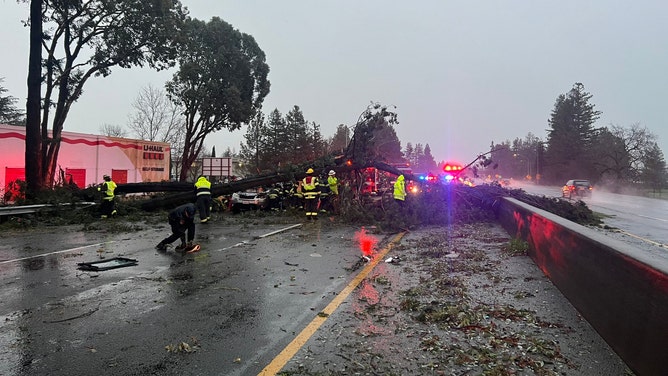
Already saturated soils, more rain and strong winds continue to knock trees into power lines and the number of Californians without power continues to rise.

(FOX Weather)
Several televised and sporting events that were supposed to be held in Southern California on Sunday have been postponed due to the extreme threat.

(FOX Weather)
While all of California will get in on the rain, areas of most concern will be along the southern coastal ranges down through the Los Angeles Basin. The heaviest rain will fall between Sunday and Monday, with the peak rainfall rates expected Sunday night.
On Monday, the Level 4 risk of flooding remains centered right over the Los Angeles metro area, while the Level 3 risk extends from just north of Los Angeles southward to the San Diego area.

(FOX Weather)
"It shows you the confidence that we know this is going to be a bigger storm," Merwin said. "It has a lot more moisture to it. There's a much larger flood threat for Southern California.
The Los Angeles metro area may see 5 inches or more by the middle of the week. Los Angeles only averages just over 14 inches of rain per year. As mentioned earlier, the surrounding mountains and their foothills could see 10-12 inches of rain. Favored mountains and foothills could see 8-15 inches of rain or more.

(FOX Weather)
Several feet of snow likely in Sierra Nevada
The plume of moisture will generate a significant winter storm for the Sierra Nevada, with 4-6 feet of snow likely above 5,000-6,000 feet, the FOX Forecast Center said. Disruptions to daily life, including difficult to impossible travel conditions, are expected.
In the mountains of Southern California, snow levels are expected to be around 7,000 feet, but 2–4 feet of snow is possible above that level.

(FOX Weather)
Damaging winds for San Francisco, Central and Northern California coast
In addition to the heavy rain threat, damaging winds have been punishing the Central California coast southward toward Santa Barbara. This includes parts of the San Francisco Bay Area.
High Wind Warnings for gusts to 70 mph will work their way down the coast through the evening and overnight hours.
Already, Funt Ranch saw an 88 mph gust, while San Francisco International Airport clocked two gusts over 70 mph, including a 77 mph gust Sunday afternoon. Pebble Beach saw a 65 mph gust and Oakland a 62 mph gust.
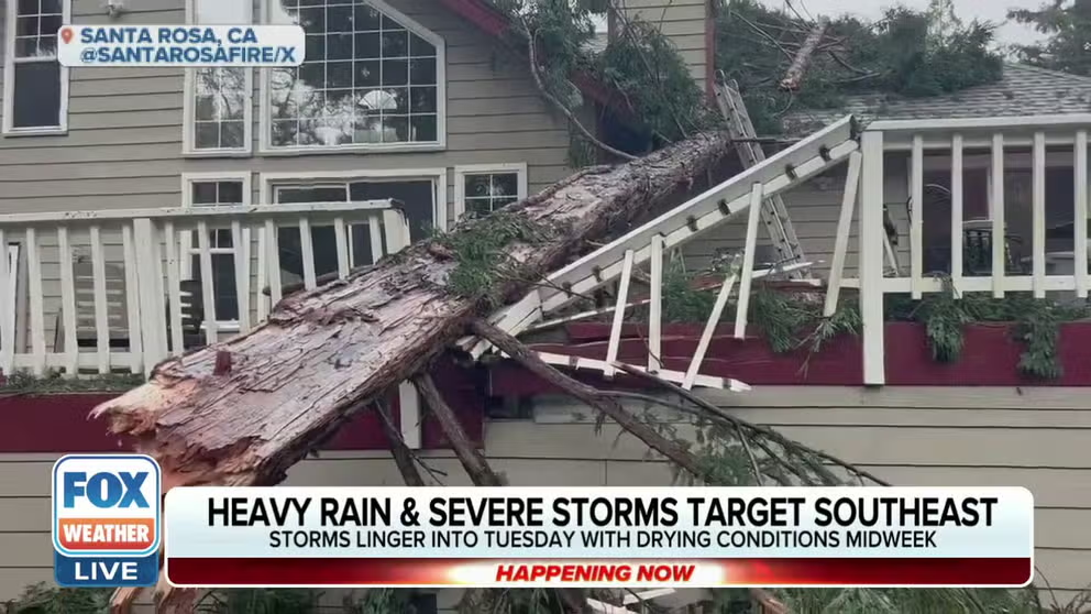
Some 50 miles north of San Francisco in Santa Rosa, a driver was injured after a tree fell onto their vehicle on Highway 101 northbound on Sunday morning, according to the Sonoma County Fire District.
A large tree fell onto a vehicle on Highway 101 northbound in Santa Rosa, California, on Sunday, Feb. 4, 2024.
(Sonoma County Fire District / FOX Weather)
Elsewhere in Sonoma County, homes were damaged in Bodega Bay after a falling tree struck them on Sunday morning. Officials said no injuries were reported in this incident.
Even stronger winds are likely in the mountains around Southern California, with gusts reaching as high as 70-80 mph.
In southern Santa Barbara County, the strong winds toppled a massive 70-foot tree onto a condominium complex in Goleta early Sunday morning, according to Santa Barbara County Fire Department Public Information Officer Scott Safechuck. At least four adults and one dog were displaced from the complex.
At the coast, these winds will also whip up the Pacific Ocean into a frenzy with 10-20 foot waves likely to slam into beaches up and down the state.
Moisture streaming in behind the storm will keep periods of rain in the forecast through much of this week, though there will be longer dry periods between the showers to wring out.
First-ever Hurricane-Force Wind Warning issued off Central California coast
The NWS office in the Bay Area issued its first-ever Hurricane-Force Wind Warning for the waters off parts of the Central California coast, where mariners could encounter wind gusts over hurricane force (74-plus mph). Point Conception Lighthouse did register a gust of 74 mph Sunday afternoon.
"Extremely strong winds will cause hazardous seas which will likely capsize or damage vessels and severely reduce visibility," forecasters wrote in the warning.