Atmospheric river storm that drenched Los Angeles, San Diego over Easter weekend winds down
Moisture from the storm moved into Arizona on Easter Sunday as the flood threat began moving east.
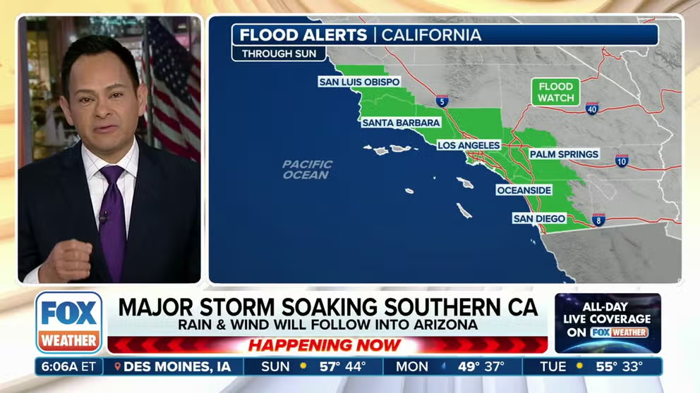
Flooding threat lingers in Southern California on Easter Sunday
The flooding threat continues in Southern California on Easter Sunday, as Flood Watches remain posted through Sunday afternoon. Major cities like Los Angeles and San Diego will see additional rounds of rain as the low-pressure system slowly moves inland near the U.S./Mexico border and eventually slides into the Southwest.
LOS ANGELES – Millions in the Los Angeles and San Diego areas were under Flash Flood Warnings on Saturday as the latest in a band of heavy rainfall soaked Southern California.
A strong area of low pressure continues to swirl along the California coast, peppering southern portions of the state with moderate to heavy rain showers and mountain snow. As the storm center moved south just off the coast toward the Los Angeles Basin on Saturday, it tapped into some tropical moisture, transitioning into a brief atmospheric river storm. Its heavy rainfall continues to trigger a flash flooding threat on Easter Sunday.

(FOX Weather)
In addition to the continued threat of flash flooding, the potential for landslides remains high throughout Southern California.
On Saturday, Los Angeles' LAX Airport reported 0.81 inches of rain in one hour between 3 a.m. and 4 a.m. and tallied 1.87 inches for the day, setting a daily record for March 30th as it vaulted past the date's previous record of 0.86 inches.
About 2.5 million residents around the San Diego metro were under a Flash Flood Warning on Sunday as Doppler radar indicated 0.25-0.75 inches of rain had fallen during a short time period. San Diego International Airport picked up 1.30 inches of precipitation on Saturday, topping the previous record for March 30th of 1 inch.
The heavy rainfall in San Diego caused a section of a road to collapse in the city's Little Italy neighborhood.
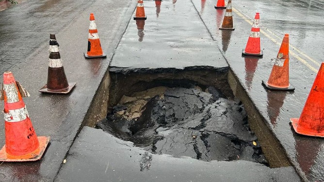
A portion of 1st Ave was closed from Nutmeg to Maple St. in San Diego, California's Little Italy neighborhood due to a section of the road that collapsed on Saturday, March 30, 2024.
(@CityofSanDiego / X)
Additional scattered showers Sunday will only add to the deluge in both Southern California cities.
CALIFORNIA’S ‘ARKSTORM’: HISTORIC 1000-YEAR FLOODS OF 1861-62 FEATURED 8 WEEKS OF ATMOSPHERIC RIVERS
Anyone traveling north of Los Angeles was expected to encounter travel issues as flooding prompted the closure of U.S. Highway 101 northbound in Santa Barbara County.
In addition to the flooding rainfall, a brief Tornado Warning was issued for Santa Barbara County just before 1:30 a.m. Saturday after Doppler radar indicated rotation in a passing thunderstorm. It was canceled 19 minutes later when the storm dissipated without reports of any tornado formation.
By the time the storm ends Sunday night, as much as 1.5-3 inches of rain is likely up and down coastal Southern California, including the Los Angeles Basin and San Diego area. Higher totals of 3-6 inches are likely in the foothills and mountains.

(FOX Weather)
"You’re talking a lot of rain here, and you’re working up against these mountain faces that allow a ton of rain to wring out over Southern California," FOX Weather Meteorologist Britta Merwin said.
Much of Southern California remains under a Flood Watch through Sunday afternoon, covering nearly 22 million people and including the cities of Los Angeles and San Diego.

(FOX Weather)
The timing of the storm couldn't be worse for those hoping to take part in traditional outdoor Easter activities. Easter egg hunts in Pasadena, Huntington Beach and Santa Anita were either canceled or postponed to a later weekend in April due to the threat of heavy rain.
Northern California not spared from heavy rain
The storm already has a history of soaking Northern California.
Steady rain tallied about a half-inch Friday in the San Francisco Bay Area, with gusty winds reaching as high as 40-50 mph, though a station along the Central Coast registered a gust of 62 mph during a passing thunderstorm.
Farther inland, about 15,000 customers lost power in San Jouaqin County, according to PowerOutage.us.
In Central California, the Pacific Coast Highway, also known as Highway 1, was closed at the San Luis Obispo/Monterey County line at Ragged Point due to slide activity north of that location, according to CalTrans.
Higher elevations get another heavy coating of snow
"Nothing says spring like snow and blowing snow in the mountains," the National Weather Service office in Los Angeles said last week ahead of the storm.
Heavy snow has been falling in the higher elevations of the Southern California mountains throughout the weekend, with 2-6 inches likely above 4,500 feet and 12-24 inches expected to pile up above 6,500 feet. There was even a low chance of snow along Interstate 5's Tejon Pass in the Grapevine.
"Traveling up and down from the mountains – both in the Sierra and also the Southern California mountains, it is not going to be fun," Merwin said. "And of course, this is the weekend that you want to do it. So be smart and be safe."
Snow will also pile up in the Sierra Nevada, where a few feet of snow will add to the snowpack now sitting at 101% of the average statewide.
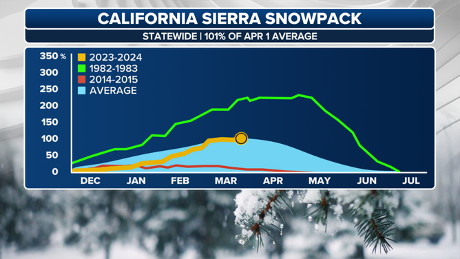
Statewide chart showing recovery of snowpack in California this year.
(FOX Weather)
Rain, wind to push into Arizona for Easter Sunday
As the low-pressure system pushes inland on Easter Sunday, rain and wind will follow into Arizona.
While it won’t be quite as wet as it was in Southern California, both Phoenix and Tucson are included in a Level 1 out of 4 flash flood threat that spans south-central Arizona.
"Anomalous (moisture), supported by deep southwesterly flow accompanying the system's associated frontal band may fuel occasional heavy rainfall, resulting in isolated flash flooding concerns across portions of southern Arizona," NOAA’s Weather Prediction Center said on Sunday morning.

(FOX Weather)