Severe Thunderstorm Watch issued for flood-stricken Missouri as more storms eye South
A Flood Watch is currently in effect for portions of central Missouri through Saturday morning, while a Flood Watch for portions of Illinois and Missouri begins at 7 p.m. CDT and lasts through Saturday morning.
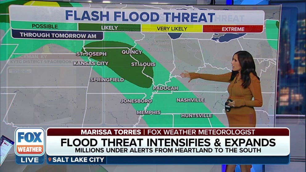
Flood threat intensifies and expands from Midwest to the South
A Severe Thunderstorm Watch has been issued for parts of Missouri. The Watches will last through the morning. August 4, 2023.
Relentless thunderstorms continue to be a serious matter in the Midwest and the South for the fourth day as flash flood emergencies prompted evacuations.
A Severe Thunderstorm Watch has been issued for parts of Missouri after days of heavy rain flooded several communities in the Show Me State this week.

(FOX Weather)
One such community was Columbia, Missouri, which broke a 113-year-old rainfall record on Thursday with 3.77 inches of rain.
A Flood Watch is currently in effect for portions of central Missouri through Saturday morning, while a Flood Watch for portions of Illinois and Missouri begins at 7 p.m. CDT and lasts through Saturday morning.
The radar loop below shows the thunderstorms developing in northwest Missouri and moving east Friday evening.

(FOX Weather)
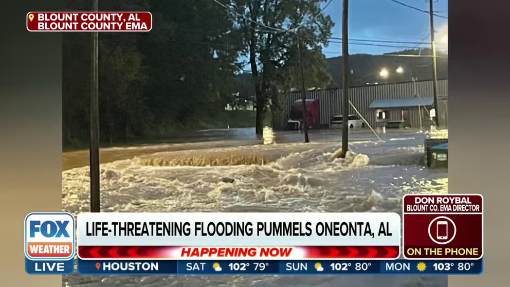
Flash flood emergencies in Alabama
Relentless thunderstorms also struck parts of the South, where flash flood emergencies prompted evacuations.
Northern Alabama was swallowed in floodwater Friday morning. Overnight water rescues in Oneonta were reported as people were left stranded on top of flooded vehicles.
Alabama officials urge caution to drivers amid flooding
Don Roybal, Emergency Management Agency director for Blount County, spoke with FOX Weather's Steve Bender and Marissa Torres about the impact of flash floods that struck Alabama. August 4, 2023.
"If you're from this area, you know that there are spots in Oneonta that do tend to flood," FOX6’s Russell Jones told FOX Weather's Amy Freeze on Friday morning. "But last night was bad."
Radar estimates of 5-plus inches of rain fell in 3 hours. Just south of the town, radar estimates of more than a half foot were recorded, with more on the way.
Jones spoke to a public safety official who said they haven't seen a mess like this in more than seven years.
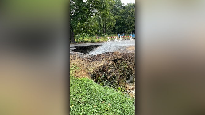
A sinkhole opened up Friday morning in Oneonta, Alabama.
(Brandon Horton)
Brandon Horton, the city's director of public safety, captured a photo of a sinkhole that opened up Friday morning due to all the rain.
"Perfect example of why you should never drive across a flooded road," the NWS in Birmingham said. "You just never know what's hiding under that water."
Nearly a foot of rain falls in a day in Tennessee
![The Tennessee Highway Patrol assisted the Obion County Sheriff's Office and Union City police with evacuations from areas affected by the historic flooding that hit the area Friday.]() Image 1 of 21
Image 1 of 21The Tennessee Highway Patrol assisted the Obion County Sheriff's Office and Union City police with evacuations from areas affected by the historic flooding that hit the area Friday. (@THPJackson/Twitter)
![The Tennessee Highway Patrol assisted the Obion County Sheriff's Office and Union City police with evacuations from areas affected by the historic flooding that hit the area Friday.]() Image 2 of 21
Image 2 of 21The Tennessee Highway Patrol assisted the Obion County Sheriff's Office and Union City police with evacuations from areas affected by the historic flooding that hit the area Friday. (@THPJackson/Twitter)
![The Tennessee Highway Patrol assisted the Obion County Sheriff's Office and Union City police with evacuations from areas affected by the historic flooding that hit the area Friday.]() Image 3 of 21
Image 3 of 21The Tennessee Highway Patrol assisted the Obion County Sheriff's Office and Union City police with evacuations from areas affected by the historic flooding that hit the area Friday. (@THPJackson/Twitter)
![The Tennessee Highway Patrol assisted the Obion County Sheriff's Office and Union City police with evacuations from areas affected by the historic flooding that hit the area Friday.]() Image 4 of 21
Image 4 of 21The Tennessee Highway Patrol assisted the Obion County Sheriff's Office and Union City police with evacuations from areas affected by the historic flooding that hit the area Friday. (@THPJackson/Twitter)
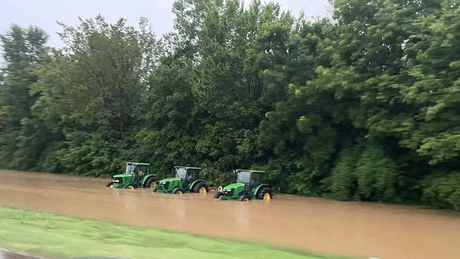
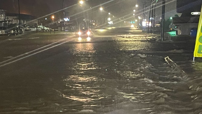
![Flooding in Union City, Tennessee. August 4, 2023.]() Image 5 of 21
Image 5 of 21Flooding in Union City, Tennessee. August 4, 2023. (Brandee Roach / Facebook)
![Flooding in Union City, Tennessee. August 4, 2023.]() Image 6 of 21
Image 6 of 21Flooding in Union City, Tennessee. August 4, 2023. (Brandee Roach / Facebook)
![Flooding in Union City, Tennessee. August 4, 2023.]() Image 7 of 21
Image 7 of 21Flooding in Union City, Tennessee. August 4, 2023. (Brandee Roach / Facebook)
![Flooding in Union City, Tennessee. August 4, 2023.]() Image 8 of 21
Image 8 of 21Flooding in Union City, Tennessee. August 4, 2023. (Brandee Roach / Facebook)
![Flooding in Union City, Tennessee. August 4, 2023.]() Image 9 of 21
Image 9 of 21Flooding in Union City, Tennessee. August 4, 2023. (Brandee Roach / Facebook)
![Flooding in Union City, Tennessee. August 4, 2023.]() Image 10 of 21
Image 10 of 21Flooding in Union City, Tennessee. August 4, 2023. (Brandee Roach / Facebook)
![Flooding in Union City, Tennessee. August 4, 2023.]() Image 11 of 21
Image 11 of 21Flooding in Union City, Tennessee. August 4, 2023. (Brandee Roach / Facebook)
![Flooding in Union City, Tennessee. August 4, 2023.]() Image 12 of 21
Image 12 of 21Flooding in Union City, Tennessee. August 4, 2023. (Brandee Roach / Facebook)
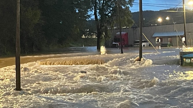
![Alabama Flooding]() Image 13 of 21
Image 13 of 21Flash flooding was reported in Blount County, Alabama on Aug. 4, 2023 (Blount County (Alabama) Emergency Management)
![Alabama Flooding]() Image 14 of 21
Image 14 of 21Flash flooding was reported in Blount County, Alabama on Aug. 4, 2023 (Blount County (Alabama) Emergency Management)
![Alabama Flooding]() Image 15 of 21
Image 15 of 21Flash flooding was reported in Blount County, Alabama on Aug. 4, 2023 (Blount County (Alabama) Emergency Management)
![Alabama Flooding]() Image 16 of 21
Image 16 of 21Flash flooding was reported in Blount County, Alabama on Aug. 4, 2023 (Blount County (Alabama) Emergency Management)
![Alabama Flooding]() Image 17 of 21
Image 17 of 21Flash flooding was reported in Blount County, Alabama on Aug. 4, 2023 (Blount County (Alabama) Emergency Management)
![Alabama Flooding]() Image 18 of 21
Image 18 of 21Flash flooding was reported in Blount County, Alabama on Aug. 4, 2023 (Blount County (Alabama) Emergency Management)
![Alabama Flooding]() Image 19 of 21
Image 19 of 21Flash flooding was reported in Blount County, Alabama on Aug. 4, 2023 (Blount County (Alabama) Emergency Management)
![Alabama Flooding]() Image 20 of 21
Image 20 of 21Flash flooding was reported in Blount County, Alabama on Aug. 4, 2023 (Blount County (Alabama) Emergency Management)
![Alabama Flooding]() Image 21 of 21
Image 21 of 21Flash flooding was reported in Blount County, Alabama on Aug. 4, 2023 (Blount County Emergency Management)

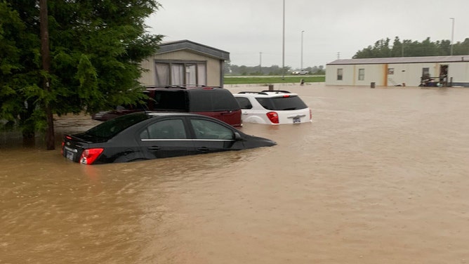
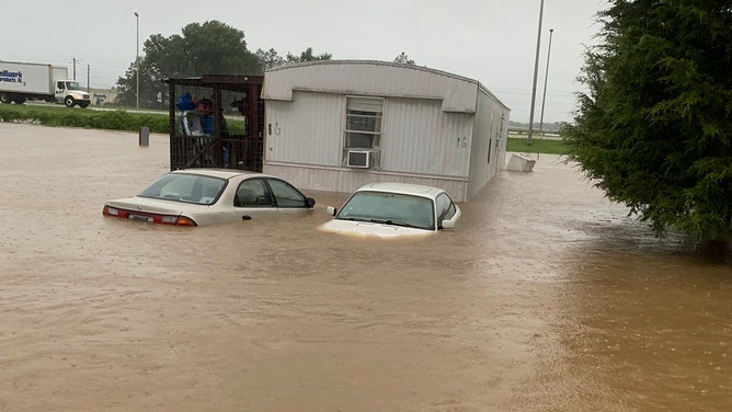
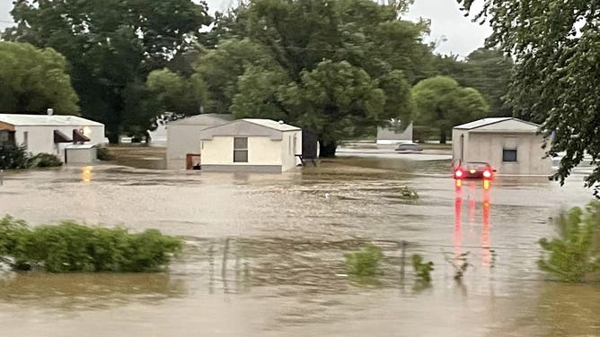
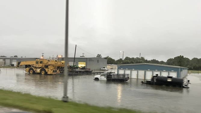
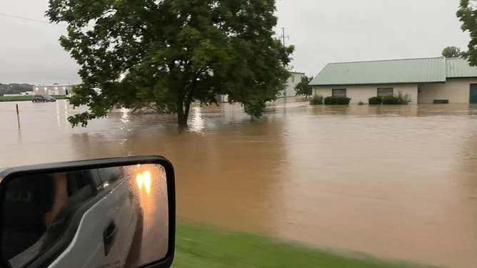

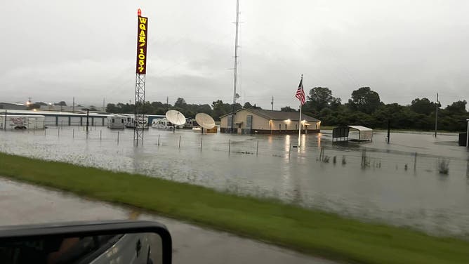
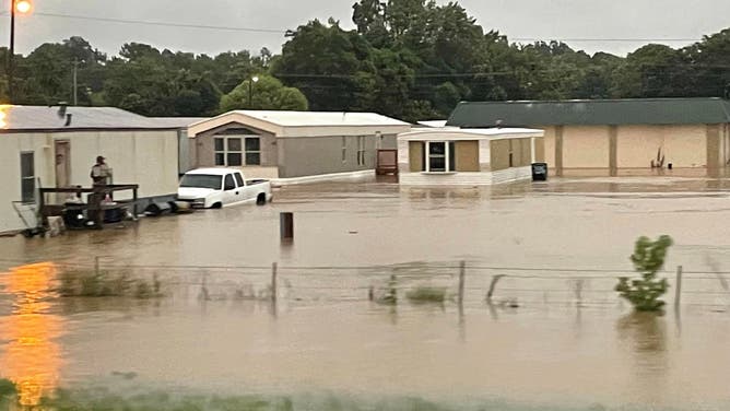

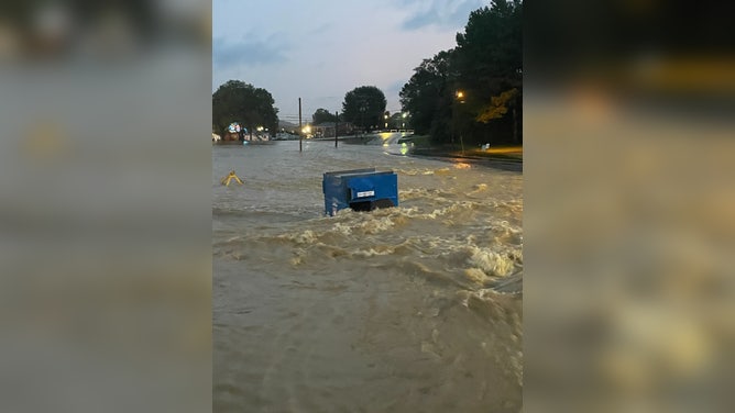

A Flash Flood Emergency was issued Friday morning for Union City, Tennessee, after thunderstorms produced over 11 inches of heavy rain in the city.
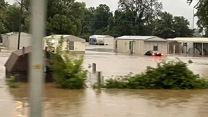
Floodwaters inundated Green Acres mobile home park, forcing residents to evacuate. Additional rainfall amounts of 2 to 4 inches are possible in the warned area.

Thunderstorm floods mobile home park in Tennessee
Residents of Green Acres mobile home park in the northwestern Tennessee town of Union City had their homes inundated by flash floods that occurred Friday morning. August 4, 2023. (Courtesy: Jimmy Wayne Riley / Facebook)
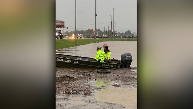
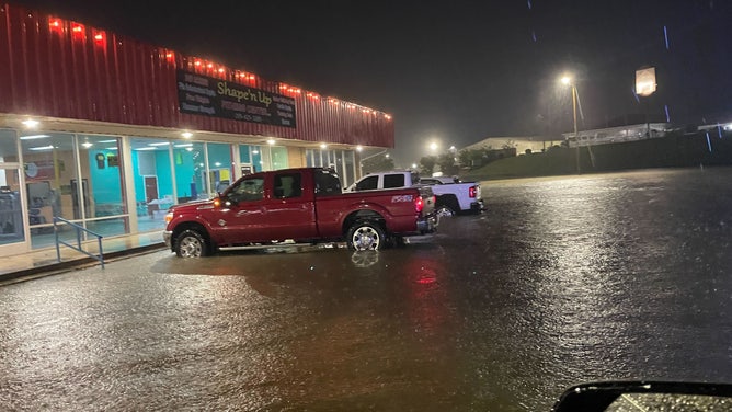
Evacuations and flooded roads in Kentucky
Another Flash Flood Emergency was issued for Hickman, Kentucky, after emergency management reported numerous roads flooded and evacuations in the city and across Fulton County. Between 4 and 7 inches of rain have fallen, with up to 3 inches more expected.
So far, there are no reports of any injuries in any of the flooding events.

(FOX Weather)
Stormy weather Flood Watches cover much of the same area Friday morning that has been drenched since Wednesday, stretching from central and southeastern Missouri through western Kentucky and into a swath of western Tennessee and even northern Alabama.