Hurricane Agatha forms in the Eastern Pacific; Landfall expected in southern Mexico on Monday
Hurricane Agatha is expected to make landfall in southern Mexico on Monday
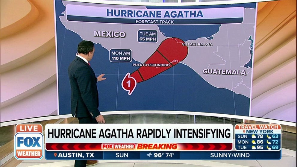
Hurricane Agatha rapidly intensifying in the Eastern Pacific
Hurricane Agatha now has winds of 85 mph with higher gusts, and it’s expected to continue to rapidly intensify before it makes landfall in Mexico.
The eastern Pacific hurricane season began on May 15, and we now have our first hurricane.
In its advisory issued at 1 p.m. Central, the National Hurricane Center said Hurricane Agatha has sustained winds of 85 mph with some higher gusts and is currently on a track to the north at 2 mph.
HOW TO WATCH FOX WEATHER ON TV

(FOX Weather)
The NHC said Hurricane Agatha is taking a turn to the northeast with a slower motion to the northeast continuing through at least Monday night.

(FOX Weather)
On its current track, the center of Hurricane Agatha is expected to approach the southern coast of Mexico later on Sunday and will make landfall there later in the day on Monday.
HURRICANE, TROPICAL STORM WATCH VS. WARNING: WHY IT’S IMPORTANT TO KNOW THE DIFFERENCE

(FOX Weather)
The NHC said Hurricane Warnings are in effect for Salina Cruz to Lagunas de Chacahua, Mexico.
A Hurricane Warning means that hurricane conditions are expected somewhere within the warned area within the next 36 hours. People are urged to prepare now to protect life and property.
7 FACTS TO KNOW ABOUT HURRICANES
A Tropical Storm Warning is in effect from Salina Cruz eastward to Boca de Pijijiapan, and Lagunas de Chacahua westward to Punta Maldonado.
A Tropical Storm Warning means that tropical storm conditions are expected somewhere within the warned area.

(FOX Weather)
Hurricane Agatha is expected to produce heavy rain over parts of southern Mexico later on Sunday and is expected to continue through Tuesday night.
In terms of totals, 10 to 16 inches of rain is possible in the state of Oaxaca, with up to 20 inches possible. Life-threatening flash flooding and landslides may occur.
In the state of Chiapas, 5-10 inches of rain is expected to fall, with some areas seeing up to 15 inches of rain. Flash flooding and landslides are also possible in this region due to the heavy rain.
Elsewhere, 2-6 inches of rain could fall in the state of Guerrero, with up to 10 inches possible. And 2 to 4 inches of rain is expected in the states of Vera Cruz and Tabasco, with up to 6 inches possible.
EASTERN PACIFIC HURRICANE SEASON BEGINS MAY 15: HERE'S WHAT THAT MEANS FOR THE US
The formation of Agatha forming before June 10 beat the climatological date of the naming of the first cyclone in the Eastern Pacific.

The hurricane season in the Eastern Pacific began on May 15 but the first storm isn't usually named until June 10.
(FOX Weather)
Forecasters will closely watch the remnants of the disturbance and its moisture as it makes its way through Central America next week.
CLICK HERE TO GET THE FOX WEATHER UPDATE PODCAST
The National Hurricane Center will keep an eye on the remnants of Agatha midweek when the energy moves over Central America.
The Atlantic basin will officially enter its annual hurricane season on June 1, and for the first time in eight years, there will likely not be any preseason development.
Forecasters warn even though the basin appears quiet now, they are anticipating the season to be busier than average.

The NOAA and Colorado State University 2022 Atlantic hurricane season outlooks compared to 2021 and the 30-year averages (1991-2020).
(FOX Weather)