

Alaska’s Suicide Basin shows the hidden danger of glacial lake outburst floods
At Alaska’s Suicide Basin, scientists closely monitor the threat to help protect communities downstream from annual glacial lake outburst flooding.
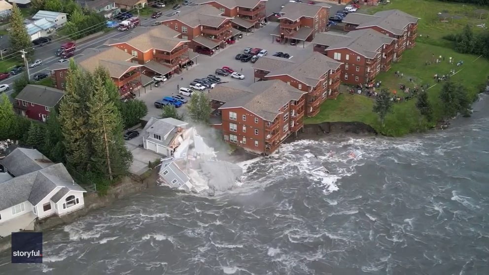
FILE: Drone shows house collapsing into river during record flooding in Juneau
Drone video captured the moment a home in Juneau, Alaska, collapsed into the Mendenhall River on August 5 during record flooding.
THE TAKEAWAY
- Glacial lake outburst floods (GLOFs) can send destructive waters and debris racing downstream with little warning.
- Alaska’s Suicide Basin produces near-annual GLOFs, but close monitoring helps protect Juneau.
- Remote Himalayan communities face greater danger when high-mountain lakes are not monitored.
JUNEAU, Alaska – With little warning, water trapped behind a glacier or natural dam can suddenly break free, unleashing torrents of water, ice and debris that have caused some of the world’s most devastating and unexpected natural disasters.
Known as a glacial lake outburst flood, or GLOF, the phenomenon occurs when water trapped behind a glacier or loose moraine dam suddenly breaks free, sending a powerful surge racing downstream.
WHAT IS A GLACIAL COLLAPSE? HOW COLLAPSING ICE CAN TRIGGER DEADLY FLOODS, LANDSLIDES AND TSUNAMIS
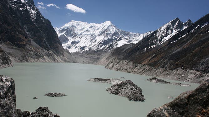
Tsho Rolpa Lake, a moraine-dammed glacial lake in Nepal’s Himalayas. The expanding lake remains closely monitored because a dam failure could trigger a destructive glacial lake outburst flood downstream.
(ICIMOD)
The U.S. Geological Survey (USGS) said these lakes can fail when their natural dams collapse or when an avalanche, landslide or heavy rain sends water over the barrier, rapidly eroding it and unleashing a destructive flood downstream.
The downstream dangers of sudden mountain flooding were on full display in Nepal this week, when a suspected glacier collapse sent a massive debris flow thundering downriver through the Himalayas with little warning, delivering a deadly blow to riverside communities.
ALASKA LANDSLIDE UNLEASHED ONE OF THE LARGEST TSUNAMIS EVER RECORDED, NEW STUDY SHOWS
Preliminary analysis indicates the Himalayan disaster was not a GLOF, but a glacier collapse and ice-rock avalanche that triggered a colossal flash flood. Even so, it laid bare the same downstream danger: fast-moving water and debris struck with little warning, wiping out communities, infrastructure and power grids while displacing thousands.
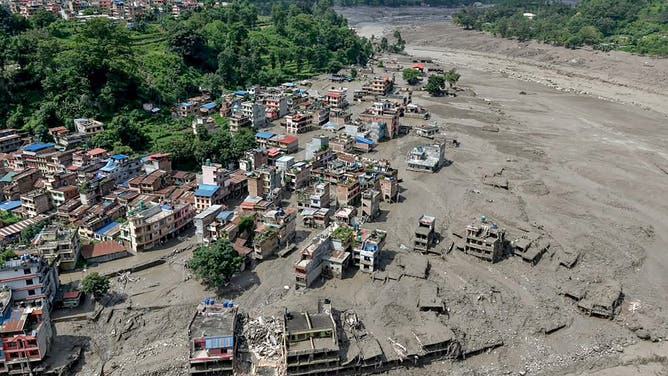
Houses lie partially submerged in muddy water along a riverside after flash floods at Trishuli Bazar in Nepal's Nuwakot district on August 26, 2026. A massive flood swept through Nepal's northern Rasuwa district on August 26, damaging roads and power infrastructure as authorities scrambled to assess the scale of the destruction.
(Photo by Prabin RANABHAT / AFP via Getty Images / Getty Images)
Throughout history, the sudden, unpredictable power of glacial lake outburst floods has devastated communities living far below the mountains where they begin.
According to the USGS, GLOFs can strike with little warning, sending fast-moving water and debris far downstream to destroy homes, roads, bridges and critical infrastructure — and, in steep valleys, transform into even more destructive debris flows.
AT LEAST 90 AMERICANS REMAIN MISSING FOLLOWING DEADLY FLASH FLOOD THAT DEVASTATED NEPAL
According to Peru’s Ministry of Environment, a section of the Palcaraju Glacier collapsed into Lake Palcacocha on Dec. 13, 1941, unleashing a torrent of mud and debris that reached Huaraz in about 15 minutes and killed roughly 1,800 people.
A sudden breach of the natural moraine dam at Cirenmaco Lake in Tibet on July 11, 1981, unleashed a GLOF with a peak discharge of 15,920 cubic meters per second — about 16 times the Boqu River’s average annual flood, according to scientific analysis.
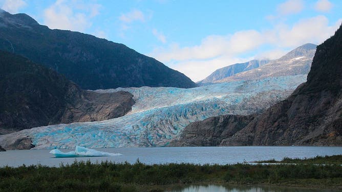
Mendenhall Glacier with detached iceberg, near Juneau, Alaska, blue glacier color.
(Education Images/Universal Images Group via Getty Images)
The debris-laden torrent traveled more than 50 kilometers into Nepal, carrying an estimated four million cubic meters of sediment and destroying infrastructure downstream — a stark example of the destructive, fast-moving mountain flooding GLOFs can unleash in the Himalayas, a reminder of the same downstream danger seen in Nepal’s deadly glacier-collapse disaster.
Glacial lake outburst floods have caused some of the world’s worst little-known natural disasters, and the hazard unfolds on U.S. soil each summer. At Alaska’s Suicide Basin, however, scientists closely monitor the threat to help protect communities downstream.
LOOKING BACK AT JAPAN’S HISTORIC TSUNAMI DISASTER 15 YEARS LATER
Alaska's Suicide Basin
About 10 miles from downtown Juneau, Alaska’s Suicide Basin has a near-annual history of unleashing outburst floods that inundate the Mendenhall Valley and threaten the state capital.
Since 2011, glacial lake outburst floods from Suicide Basin have inundated Mendenhall Lake and the Mendenhall River nearly every summer, even swallowing condemned homes in August 2023.
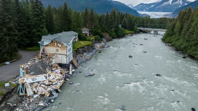
The remains of a home that collapsed due to erosion from a glacial outburst flood into the Mendenhall River in Juneau, Alaska on August 8, 2023. A then record glacial outburst flood destroyed and condemned homes in Alaska's capital city.
(Christopher S. Miller for The Washington Post via Getty Images / Getty Images)
According to the USGS, Suicide Basin is a partly glacierized side basin along Mendenhall Glacier near Juneau, where rain and snowmelt collect behind an ice dam before draining beneath or around the glacier into Mendenhall Lake and the Mendenhall River.
GLOFs are a summer phenomenon for Suicide Basin dating back to 2011, when the retreating Suicide Glacier left behind a basin that could fill with meltwater and rainfall – creating a basin in its namesake.
WHICH NATURAL DISASTER SCARES AMERICANS THE MOST? SURVEY REVEALS THE ANSWER
With a known track record of frequent flooding build-up, the glacier-dammed basin into a closely watched source of flooding downstream.
The National Weather Service monitors Suicide Basin alongside the USGS and local partners, tracking basin water levels and downstream conditions to forecast potential releases and issue flood warnings.
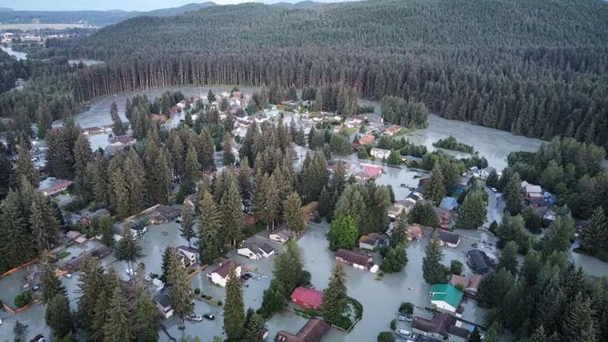
Aerial view of homes inundated by floodwaters in Juneau’s Mendenhall Valley on Aug. 6, 2024, after a glacial lake outburst flood from Suicide Basin.
(City of Borough of Juneau / Facebook)
Real-time monitoring allows the USGS and National Weather Service to identify when a Suicide Basin outburst is becoming likely and forecast its potential timing and severity, though the exact onset and magnitude can still vary.
The latest release from Suicide Basin occurred on Aug. 13, 2026, pushing the Mendenhall River to a 14.7-foot crest — the fourth-highest on record and within the major flood category, according to the National Weather Service, prompting evacuations and road and facility closures as the Mendenhall River rose into major flood stage.
At Suicide Basin, real-time monitoring and flood forecasts give emergency officials a chance to warn residents and prepare for the next release.
Elsewhere in the world, particularly in remote, unmonitored mountain valleys, the sudden failure of an ice or moraine dam can leave communities with little warning and few defenses against a fast-moving wall of water, debris and destruction.