Northeast spared from blockbuster holiday weekend winter storm, light snow still possible for millions
Like many relationships, the Valentine's Day weekend forecast remains... complicated.
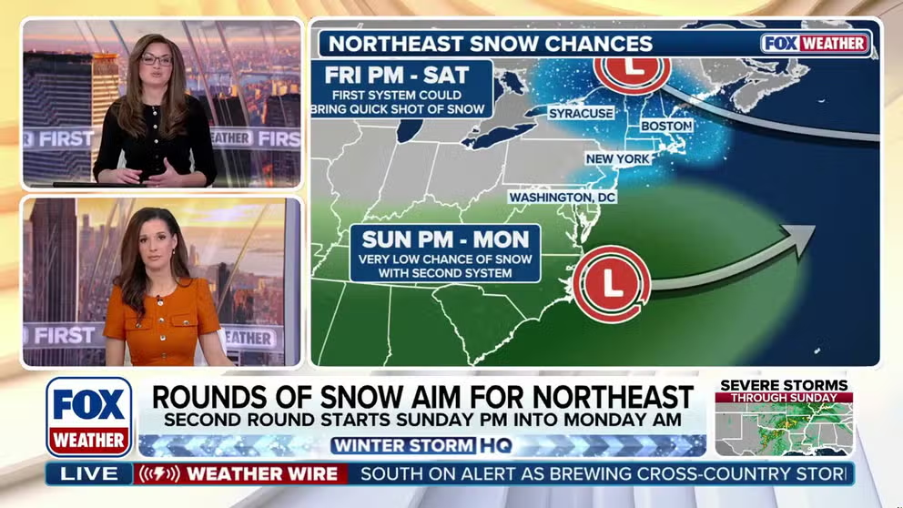
Two shots of snow possible across Northeast over holiday weekend
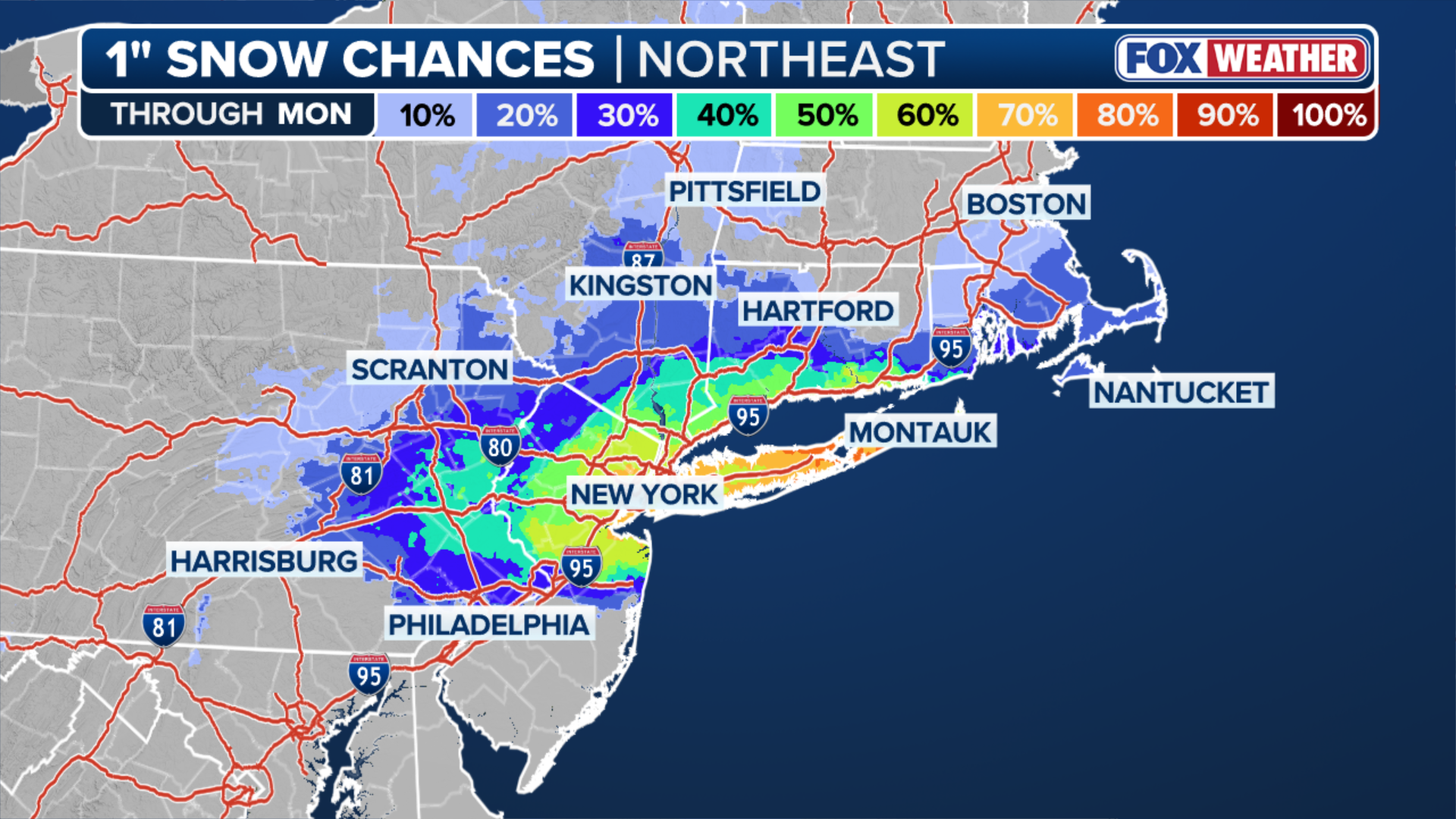
The FOX Forecast Center is tracking two rounds of snow, one more likely than the other, but both may impact the Interstate 95 corridor this holiday weekend. The first round of snow will roll into western New York starting later Friday afternoon. This system will be a "quick hitter," bringing light snow for no more than a couple of hours to cities from Syracuse, New York to New York City. While the chance of a blockbuster blizzard has faded, a second round of light snow is possible Sunday night into Monday. The best chance for measurable snow appears to be from the mountains of West Virginia and Pennsylvania toward the Tri-State Area, where a 50 percent chance for one inch of snow exists.
NEW YORK – The FOX Forecast Center is closely monitoring two possible rounds of snow, one more likely than the other, forecast for the Northeast this Valentine's and Presidents' Day weekend. Fortunately for those celebrating this holiday weekend, a major winter storm appears to be unlikely, according to the latest computer forecast models.
![NEW YORK, NEW YORK - FEBRUARY 09: Ice floes cover part of the Hudson River along the Manhattan shoreline as New York City continues to experience frigid temperatures on February 9, 2026, in New York City]() Image 1 of 4
Image 1 of 4NEW YORK, NEW YORK - FEBRUARY 09: Ice floes cover part of the Hudson River along the Manhattan shoreline as New York City continues to experience frigid temperatures on February 9, 2026, in New York City. (Spencer Platt)
![HOBOKEN, NJ - JANUARY 26: A person jogs along a snow-covered walkway in front of the skyline of lower Manhattan and One World Trade Center in New York City on January 26, 2026, in Hoboken, New Jersey.]() Image 2 of 4
Image 2 of 4HOBOKEN, NJ - JANUARY 26: A person jogs along a snow-covered walkway in front of the skyline of lower Manhattan and One World Trade Center in New York City on January 26, 2026, in Hoboken, New Jersey. ( (Photo by Gary Hershorn/Getty Images))
![05 December 2025, USA, Washington: Snow lies in front of the Lincoln Memorial (background) during the first snowfall of the winter season.]() Image 3 of 4
Image 3 of 405 December 2025, USA, Washington: Snow lies in front of the Lincoln Memorial (background) during the first snowfall of the winter season. (Photo: Thomas Müller/dpa (Photo by Thomas Müller/picture alliance via Getty Images))
![]() Image 4 of 4
Image 4 of 4A person crosses the street in Copley Square during a snowstorm in Boston, Massachusetts, on January 25, 2026. (Joseph Prezioso / AFP via Getty Images)


The first round of snow is expected to roll into western New York starting later Friday afternoon.
According to the FOX Forecast Center, this system will be a "quick hitter," bringing light snow for no more than a couple of hours to parts of upstate New York.
Snow could reach New York City, northern New Jersey, and western Connecticut late Friday night.
(FOX Weather)
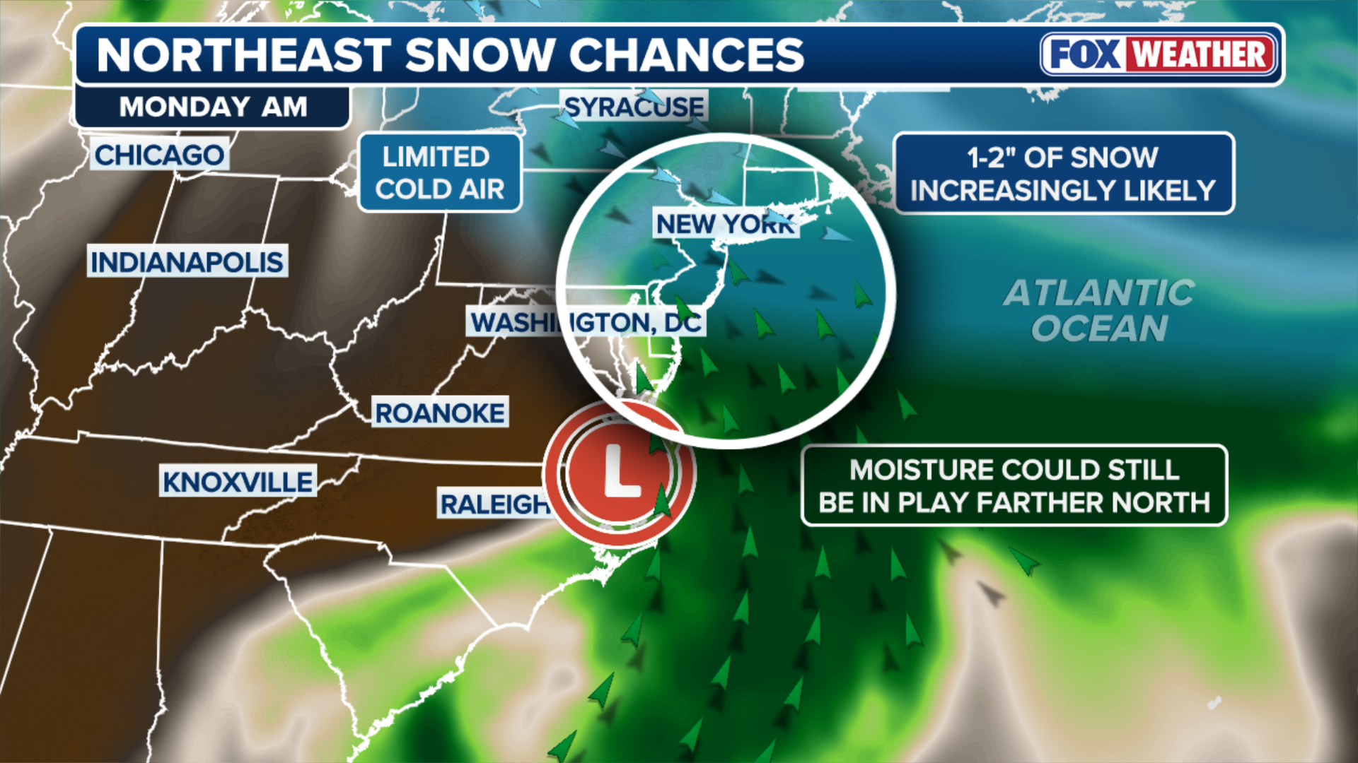
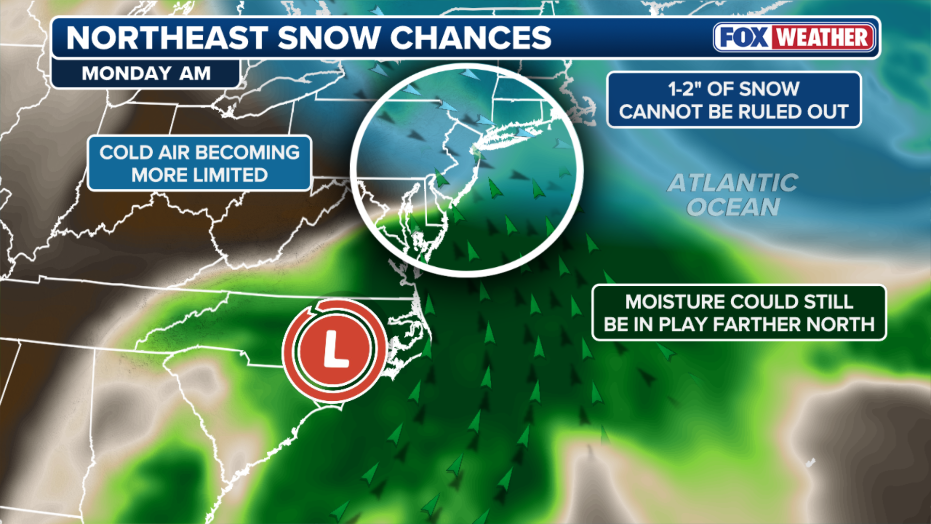
A second period of light snow is possible Sunday night into Presidents' Day across a corridor from West Virginia through the New York-New Jersey tri-state area and the southern New England coast, but some uncertainty remains due to a complicated atmospheric setup.
The FOX Forecast Center is tracking two main areas of low pressure that would need to merge at the same time, as well as enough cold air, in order to produce heavy snow across the northeastern portion of the Interstate 95 corridor.
MILLIONS ACROSS THE SOUTH FACE BREWING CROSS-COUNTRY STORM AS FLOOD THREAT INCREASES
Currently, it appears that these forecast ingredients will pass through the region as separate, weaker entities rather than merging into a powerful snowstorm.
(FOX Weather)
The main system being watched is a powerful cross-country storm that will soak millions across the South this weekend.
Forecasters are monitoring how far north that system will move once it slides off the Southeast coast sometime Sunday night and whether enough cold air from Canada will be available for that storm to tap into.
LIVE UPDATES: CALIFORNIA CLOBBERED BY SNOW AS MAJOR SOUTHERN STORM BREWS FOR VALENTINE’S WEEKEND
(FOX Weather)
"The best chance for measurable snow appears to be from the mountains of West Virginia and Pennsylvania toward the Tri-State Area, where a 50 percent chance for one inch of snow exists," the FOX Forecast Center said Friday.
Regardless, the impacts shouldn't cause tremendous changes to any date night plans or a Presidents' Day trip to the local car dealership.
Check back for updates on this developing story.