Live updates: California clobbered by snow as major Southern storm brews for Valentine’s weekend
Live updates: California clobbered by snow as major Southern storm brews for Valentine’s weekend
Download the AppLIVE coverage from FOX Weather continues
View postCoverage for this event has ended.
LIVE coverage has ended here, but our around-the-clock coverage continues.
Weather has caused delays at major airports in California and New York.
San Francisco International Airport is currently experiencing a ground stop and there is a departures delay in effect at LaGuardia Airport in Queens.
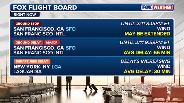
FOX Forecast Center's Flight Board tracks
SFO is experiencing light rain, with wind gusts reaching up to 24 mph, with a moderate misery index of a 2/4 as 24% of flights have been disrupted.
It is partly cloudy in New York, with wind gusts reaching up to 26 mph, with a low misery index of a 1/4 as just 268 flights have been delayed across the three major NYC area airports.
According to flightaware.com, over 230 flights have been delayed at SFO, over 150 flights have been delayed at Chicago O'Hare International Airport, Los Angeles International Airport has clocked 150 delays and Denver International Airport has had over 120 delays today.
Commissioner of the New York City Department of Buildings Ahmed Tigani joined FOX Weather to talk about all the city is doing to combat the newest winter weather threat facing the Big Apple.
As we move past the midpoint of February 2026, many are asking if the bone-chilling subzero temperatures that defined the start of the year are finally a thing of the past. While winter isn't officially over, several major atmospheric signals suggest the most extreme arctic blasts are likely behind us.
Weather experts are tracking a major shakeup in the high-altitude winds known as the Polar Vortex, which could mean a roller coaster of temperatures for the U.S. through the end of February.
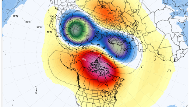
Global Forecast System (GFS) model showing the pressure anomalies in the stratosphere early next week. (Source: WeatherBELL)
Right now, a significant disruption is currently hitting the polar vortex—the largest one observed all winter. For the average American, this means the weather is about to trade places. Warmer weather will take over the East while the West feels the chill.
Don't get too comfortable with the warmth in the East. Experts say the current polar vortex is like a spring, ready to release. There are strong signs that the pattern could resort back to the winter's dominant trend—mild in the West and cold in the East—by late February or early March. But even that won't have lasting power.
Time is ticking for winter and the changing of the seasons is already underway. While cold air will likely return to the East in the coming weeks, it's expected to be transient and less extreme. The days are getting longer as spring approaches, which will help warm things up in the months ahead. It's only a matter of time before millions will be sweating through summer as things heat up.
A big thaw is underway in the Big Apple following weeks of historic cold. New York City's Central Park reached 40°F this afternoon for the first time since January 22.
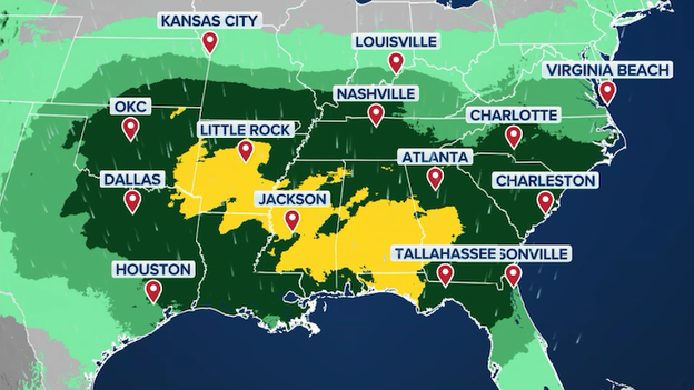
A multi-day storm system is set to track across the United States this weekend, bringing a threat of strong to severe thunderstorms and flash flooding to the Deep South.
While much of the weekend's weather will be dominated by a widespread washout, meteorologists are highlighting a specific window on Saturday where storm dynamics could turn severe.
The FOX Forecast Center says current analysis suggests the highest coverage for potential severe weather spans from the Southern Plains into the Southeast. West Texas faces the first threat of storms that could produce large hail on Friday night. From there, Louisiana and Arkansas could see strong storms developing as early as Saturday morning, with coverage becoming more widespread throughout the day. For Mississippi and Alabama, the threat is expected to peak during the late evening and nighttime hours as the system shifts eastward.
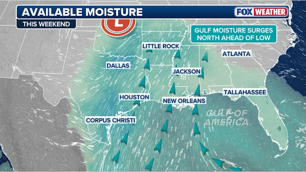
Moisture from the Gulf of America will surge north into the Southeast to produce widespread rain and thunderstorms this weekend.
Several atmospheric ingredients are coming together to increase the risk of organized severe storms this weekend.
- Gulf moisture: As the low-pressure system organizes over the South Central states, it will tap into a deep reservoir of moisture-rich air from the Gulf of America.
- Record warmth: Temperatures across the southern tier are running 15–20°F above average. Forecast highs in the 60s to low 70s will provide the fuel (instability) needed to sustain thunderstorms.
- Storm dynamics: A potent upper-level disturbance moving out of the Southwest will provide the necessary lift to trigger convection.
While a widespread outbreak is not expected, residents should be prepared for several high-impact weather hazards that include damaging winds, hail, flash flooding, and a few tornadoes.
Florida Governor Ron DeSantis has unlocked emergency assistance for farmers after extreme cold and drought conditions hit the state.
I signed Executive Order 26-33 in response to last week's winter weather event and ongoing drought conditions throughout the state.
The order specifically facilitates emergency harvesting by allowing state officials to relax restrictions on commercial vehicles, ensuring vulnerable crops reach processing sites without delay. The governor is working to expedite recovery and prompt assistance to prevent further losses for farmers across the state.
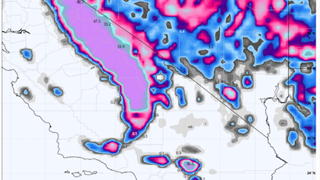
European Centre for Medium-Range Weather Forecasts (ECMWF) model showing huge snow amounts for California over the next seven days.
Today's atmospheric river event is delivering a solid 12 to 36 inches to the Sierra Nevada through Thursday, but pales in comparison to what's to come.
FOX Weather meteorologists say things get "insane" next week when a persistent moisture funnel could drive total accumulations to between 5 and 10 feet in the high country.
This follows a historically dry stretch where many Western locations are experiencing their warmest winter on record. The shift from a wretched snow season to potentially seeing 10 inches of liquid equivalent in California is a dramatic turn.
The Upper Colorado Basin and Sierra Nevada have been sitting near 50% of normal snowpack. This incoming series of storms is forecast to be so significant that it could erase those deficits almost entirely in just a matter of days.
A potent storm will dump heavy rain and raise the risk of flash flooding in the South this weekend.
- California snow slam: An impactful atmospheric river is moving through the Golden State today. The Sierra Nevada mountains are braced for 12–36 inches of snow through Thursday, creating difficult to impossible travel conditions.
- Southern Valentine’s storm: A developing low-pressure system is locked on a path toward the Deep South. Heavy rain is forecast to begin Friday, spreading into Valentine’s Day (Saturday).
- Flood threat: Rain totals of 1–4 inches are expected from Texas to the Carolinas, with localized amounts up to 6 inches possible along the Gulf Coast, threatening outdoor weekend plans and travel.
- Severe storm threat: While flash flooding is the main concern this weekend, the FOX Forecast Center is monitoring the risk of severe thunderstorms from Texas to Mississippi over the weekend.
- Northeast thaw: As the major cross-country systems brew, the Northeast is finally seeing a reprieve from life-threatening wind chills as temperatures warm back up toward seasonal averages.
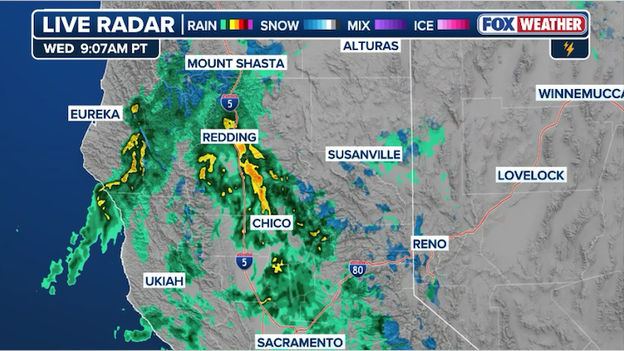
Rain and mountain snow hitting California as a potent storm system hits the West Coast.
California is getting much-needed rain and snow today thanks to a storm sliding into the West. Lower elevations and coastal sections of the state are seeing plain rain, while the Sierra Nevada mountains are benefiting from heavy snow. This is just the first of a series of storms expected to bring beneficial rain and snow to the state in the days ahead.
While a major southern storm is set to drench the Gulf Coast this Valentine’s weekend, the FOX Forecast Center is closely watching a high-stakes "triple play" of atmospheric features that could still bring snow to the I-95 corridor.
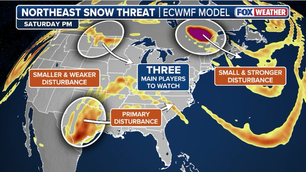
FOX Weather meteorologist are closely tracking three main players that could lead to snow in the Northeast this weekend.
The first player is a northern stream disturbance diving southeast, which must perfectly "phase" with a moisture-laden southern stream moving out of Baja California. If these two systems synchronize, they could pull the storm's track northward; however, current forecast modeling suggests they may remain separated, keeping the heaviest precipitation suppressed as a cold rain for the South.
The final piece of the puzzle is the polar vortex, which is currently departing the Northeast. For a "White Valentine's" in cities like New York and Boston, this feature needs to leave behind enough lingering cold air to prevent the storm from turning into a simple washout.
While the odds of a major snowstorm remain low due to the difficulty of aligning all three features, the window for a wintry surprise on Sunday night into Monday has not yet slammed shut.
As the 2026 Atlantic hurricane season approaches, FOX Weather meteorologists are closely monitoring a major shift in the Pacific that could dictate whether this year is active or subdued. While some initial long-range predictions project activity levels near the 30-year norm, the true outcome depends on several competing climate wildcards.
The most significant factor for the 2026 season is the El Niño-Southern Oscillation (ENSO). NOAA says the current La Niña is weakening quickly, with a 75% chance of transitioning to a "neutral" phase by late winter or early spring. Subsurface waters in the eastern Pacific are already warming rapidly, suggesting a shift toward El Niño could happen as early as mid-summer 2026.
El Niño typically acts as a "hurricane killer" in the Atlantic by increasing vertical wind shear. These strong upper-level winds can tilt or rip apart developing storms before they can intensify.
If a moderate-to-strong El Niño develops by the peak of the season (August–October), 2026 could see reduced activity. That's thanks in part to increased westerly winds over the basin that disrupt tropical organization, an increase in atmospheric stability and sinking air over the Atlantic that could make it harder for thunderstorms to grow, and periodic bursts of Saharan dust can further dry out the atmosphere and reflect solar radiation, keeping ocean temperatures cooler.
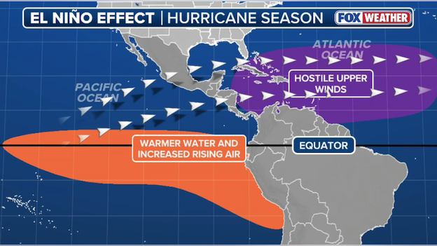
El Niño typically increases hostile upper-level winds over the Atlantic Basin, which can tear apart developing tropical systems.
Despite El Niño's suppressing power, above-average sea surface temperatures in the Atlantic could offset these effects. Warm water is the primary fuel for hurricanes; if the tropical Atlantic remains significantly warmer than average—as it has been in recent years—storms may still find enough energy to overcome high wind shear.
'It only takes one.' Even in seasons with below-average activity, the risk to life and property remains high. Some of the most destructive hurricanes in history have occurred during overall "quiet" years. For example, 1992 was a below-average season, yet it produced Hurricane Andrew, a Category 5 storm that devastated Florida.
It comes down to where any tropical threats may go. A season with few storms can still be catastrophic if the steering patterns drive even one major hurricane toward a populated coastline.
While early signals point toward a transition that could favor a less active season, the combination of warm Atlantic waters and unpredictable steering currents means America's coastal residents should never let their guard down.
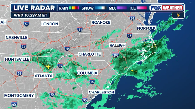
Radar image showing showers stretching from Georgia to North Carolina right now.
A cold front is sliding across the South this morning, sparking showers from Georgia to the Carolinas. But the real soggy story is brewing for the holiday weekend. A massive 1,000-mile-wide storm system is taking aim at the region, promising a widespread drenching for Valentine's Day.
Stay ahead of the storm this Valentine's Day by using the 3D interactive radar on the FOX Weather app to track rain and snow in real-time.
The FOX Weather app uses real-time data to let you navigate through blizzards, hurricanes, or simple rain showers with ease. You can even customize your view by adding layers for lightning to see exactly what is headed your way.
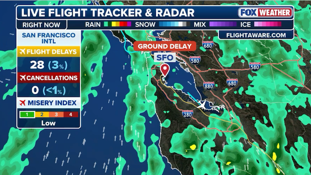
Dozens of flights to San Francisco International Airport are facing delays due to wind.
Flights heading to San Francisco International Airport are facing delays this morning thanks to the storm hitting California. The Federal Aviation Administration says flights destined to SFO are facing 1-hour delays due to winds.
A powerful cross-country storm is forecast to develop over the South Central states late this week, bringing widespread heavy rain and thunderstorms from Texas to the Carolinas. The system will bring a multi-day flash flood risk to several major hubs:
- Friday: The threat begins in Texas and Oklahoma, focusing on areas near Oklahoma City, Wichita Falls, and Sweetwater.
- Saturday (Valentine’s Day): The flood risk intensifies and shifts into the Ark-La-Tex region. A Level 2 (Slight Risk) of flash flooding covers much of Arkansas—including Little Rock—and parts of northern Mississippi.
- Sunday: Rain spreads into the Southeast, with a flash flood threat reaching Atlanta, Charlotte, and Jacksonville.
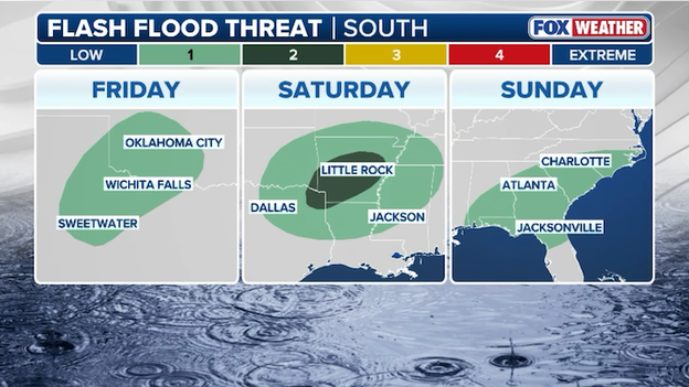
A multi-day flash flood threat will develop over the weekend from Texas to the Carolinas.
1–4 inches of rain is expected for most, though localized areas could see up to 6 inches where storms repeatedly move over the same terrain. While this rain will offer critical relief to drought-stricken areas in Georgia and Arkansas, it is expected to disrupt outdoor holiday plans and could impact travel.
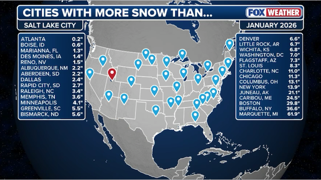
Most of America has recorded more snow this winter season than Salt Lake City, Utah.
Salt Lake City is currently navigating a historic snow drought, with nearly 330 days passing since the city last recorded a single inch of snow in a 24-hour period. This unusual winter has been so lopsided that unlikely Southern cities like Marianna, Florida, and Atlanta have actually out-paced the world-class ski destination in seasonal snow totals.
A storm system moving through the Southwest is set to bring a threat of severe weather to parts of Texas this Friday night. As an upper-level disturbance shifts east from Mexico toward the southern Rockies, it will tap into moisture surging northward from the Gulf of America. By Friday evening, elevated instability will build across the Trans-Pecos, Permian Basin, and the Red River Valley. This creates a prime environment for scattered thunderstorms to develop after sunset.
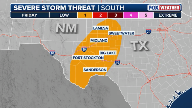
Severe thunderstorms could fire up across West Texas on Friday night and drop big hail from Midland to the Mexico border.
While most of the storms are expected to stay high in the atmosphere—meaning a lower risk for tornadoes—the wind profiles appear favorable for supercells. These stronger, rotating storms could produce isolated large hail (up to 1 inch in diameter) and strong wind gusts as they move across the state overnight.
A major shift in the jet stream is about to flip the script on the U.S. weather map. After a winter where the West baked under record-breaking warmth and the East shivered through a brutal polar vortex, the patterns are trading places.
By late this weekend, a massive dip in the jet stream will anchor itself over the Western U.S., opening a firehose of Pacific moisture that could dump 8 to 10 feet of snow on the highest mountain peaks by the end of next week.
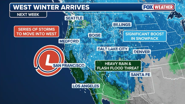
A series of storms are expected to bring a significant boost to the snowpack across the West through next week.
This pattern flip is the news water managers and skiers have been waiting for. The West is currently reeling from a historic snow drought; the Upper Colorado Basin is at an all-time record low for snowpack, and the lack of moisture has been staggering. To put the deficit into perspective, Salt Lake City hasn’t seen a single inch of snow in a day in nearly 11 months, while Grand Junction, Colorado, is currently on a 440-day streak without a 1-inch snow day.
This incoming barrage of storms is expected to finally erase those deficits as moisture surges from the Sierra Nevada deep into the heart of the Rockies.
While many computer forecast models are trending toward a "Southern Soak" that stays suppressed along the Gulf Coast, meteorologists in the FOX Forecast Center are watching three critical atmospheric gears that could still shift the track north. If these features align, the I-95 corridor—including New York City and Boston—could see a wintry finish to Valentine’s weekend.
- Two streams, one storm? The biggest wildcard is the interaction between two separate jet streams. A northern stream disturbance (a shortwave trough) is currently diving southeast. If this northern energy "phases" or captures the southern stream trough moving out of Baja California, it would act like a magnet, pulling the storm farther north and intensifying it. Without this interaction, the storm remains a flat rainmaker for the South; with it, a powerful coastal nor'easter becomes possible.
- Speed vs. strength. The southern disturbance is the engine of this storm, carrying rich moisture from the Gulf of America. Its forward speed and amplitude (how deep the dip in the jet stream is) will dictate where the surface low-pressure center actually forms. A slower, stronger southern wave would have a better chance of curving up the East Coast, tapping into that moisture to produce heavy rain and snow for the Mid-Atlantic and Northeast.
- Cold air cling. Finally, there is the question of the cold air and how much hangs around. While the core of the recent arctic blast has departed the Northeast, cold air remains over the region. This cold air could act as a foundation; even if the storm tries to bring in warmer Atlantic air, that lingering chill could keep precipitation in the form of snow or ice for NYC and Boston rather than just a cold rain.
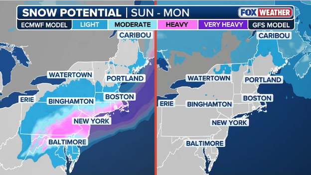
Computer forecast models show different solutions for this weekend's potential snow threat in the Northeast.
While a major snowstorm is currently a low-probability scenario, it is far from impossible. For a big snow event, all of these features must synchronize perfectly. The FOX Forecast Center will continue to monitor and provide updates throughout the day as new data pours in.
A powerful upper-level disturbance emerging from Baja California is set to trigger a significant pattern shift across the Southern U.S. just in time for Valentine’s Day weekend.
As the system organizes over the Southern Plains, widespread rain and thunderstorms are expected to develop, providing much-needed relief to a region parched by historic dry spells. For states like Arkansas and Georgia—where some areas are currently enduring their driest winters on record—this soaking could offer a vital dent in severe to extreme drought conditions.
However, the beneficial rain comes with a side of holiday headaches. The FOX Forecast Center says a widespread 2 to 3 inches of rain will fall from eastern Oklahoma through Georgia, with localized totals of up to 5 inches possible in Arkansas, Mississippi, and Alabama. This has prompted a Level 2 out of 4 flash flood risk for parts of the interior South starting Saturday.
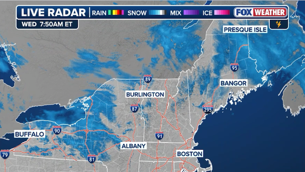
Radar showing snow showers still impacting portions of Upstate New York, Vermont, New Hampshire, and Maine this morning.
Snow is still flying in portions of the Northeast this morning after a fast-moving clipper system moved through overnight. The clipper delivered a widespread 1–3 inches of snow from upstate New York through Massachusetts. Higher elevations in Vermont, New Hampshire, and Maine saw the jackpot with 5–8 inches (and isolated totals up to 10 inches in the highest peaks).
While the bulk of the snow ended earlier this morning, snow showers continue to sprawl across the region and visibility remains reduced in areas downwind of Lake Ontario due to heavier localized bursts of snow.
After a winter dominated by stubborn high pressure and record warmth at over 120 locations, a major pattern change is finally delivering significant moisture to the drought-stricken West.
A potent low-pressure system is moving through California, bringing a critical boost to the region's parched landscape. The Sierra Nevada is expected to receive up to a foot of much-needed snow through Thursday morning, providing a vital lifeline to a snowpack currently sitting at just 50% of its seasonal average.
Winter weather alerts remain in effect across the high terrain of the Sierra, as well as parts of Utah, Colorado, and Wyoming, as the moisture surges inland to help ease the ongoing winter deficit.
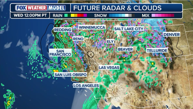
Exclusive FOX Weather Model shows mountain snow and lowland rain clobbering California today.
In the lowlands, steady rain continues to soak the coast, with San Francisco and Los Angeles bracing for up to an inch of accumulation by Thursday. This moisture is especially welcome in San Francisco, which has seen less than a third of an inch of rain so far this month—well below its typical February average.
While the rain is beneficial for water levels, officials warn that localized totals could reach 2 inches, keeping the threat of flash flooding active, particularly near sensitive burn scar locations.
You can go back and see live updates from Tuesday's coverage.
Click here to see the minute-by-minute updates from FOX Weather.
You’ve reached the beginning of this live coverage.