Live updates: Texas to Carolinas bracing for severe storms and flash floods this Valentine's weekend
Live updates: Texas to Carolinas bracing for severe storms and flash floods this Valentine's weekend
Download the AppLIVE Severe Weather HQ coverage continues
View postCoverage for this event has ended.
FOX Weather is your Severe Weather HQ, providing around-the-clock live coverage this weekend.
What began as a localized concern is now expanding into a broader severe weather threat for Saturday. A powerful shortwave atmospheric disturbance is currently racing toward the Southern Plains, set to collide with a surge of warm, humid Gulf air. This setup is expected to ignite a line of strong to severe thunderstorms stretching from central Oklahoma and Texas into the Lower Mississippi Valley by Saturday afternoon and into the evening hours.
The biggest concern is a developing line of storms that could produce locally damaging wind gusts as it surges eastward into Louisiana and Mississippi.
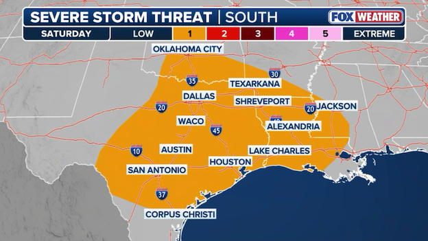
Severe storm threat has increased across Texas and Oklahoma for Saturday afternoon.
Organized updrafts in the early afternoon could support large hail, particularly in parts of western Oklahoma and North Texas.
While the overall risk remains low, meteorologists are closely watching the Texas Coast and southwest Louisiana, where a few rotating storms could develop if they manage to break away from the main line. This could spin up a couple quick tornadoes.
With Valentine’s Day plans in full swing, this is a heads-up weekend for the I-35 and I-10 corridors.
While the atmosphere may have limited fuel to create a massive outbreak, the combination of strong winds aloft and high humidity means any storm that develops could pack a punch.
A powerful storm system will sweep through the South this weekend with heavy rain and strong storms.
A massive storm system is set to bring a Valentine's Day washout to the southern tier, with widespread showers and thunderstorms from Friday night through Sunday expected to complicate outdoor holiday celebrations. While primarily a drenching rain event, an influx of Gulf moisture will provide the fuel for potentially severe thunderstorms late Friday and Saturday, carrying threats of damaging winds and large hail. Furthermore, the risk of flash flooding will increase for urban areas and low-lying neighborhoods, particularly where storms "train" or repeatedly pass over the same terrain. These conditions are likely to trigger significant travel delays at major Southern airport hubs, including Dallas (DFW), Atlanta (ATL), and Charlotte (CLT), as the system moves across the region.
Latest severe storm threat map showing the threat for hail extending into Oklahoma on Friday night.
The Storm Prediction Center has expanded the risk for severe weather into the Oklahoma City metro for Friday night as unseasonably warm air collides with an approaching cold front.
Forecasters are warning of severe storms fueled by rising instability, with the primary threats being damaging wind gusts and large hail that could impact vehicles and property into the overnight hours.
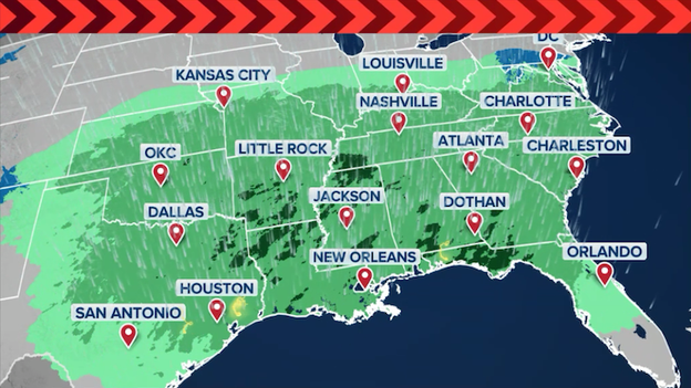
A soggy Saturday is in store for millions across the South as a massive, slow-moving storm system turns Valentine’s Day into a widespread washout. The FOX Forecast Center expects the most intense rain to stretch from East Texas and Louisiana through Mississippi, Alabama, and into Georgia, with rain chances sitting at nearly 100% for many major metro areas.
While the rain will be a welcome sight for drought-stricken landscapes, it will likely scramble outdoor holiday plans and Mardi Gras festivities, as steady downpours and scattered thunderstorms are projected to dominate the afternoon and evening hours.
Future radar showing widespread rain and thunderstorms from Oklahoma to the Gulf Coast on Valentine's Day.
The primary concern for the day is the sheer volume of water, with widespread totals of 1 to 4 inches expected across the southern tier. In areas where thunderstorms "train"—repeatedly moving over the same ground—localized amounts could spike toward 6 inches, significantly raising the risk for flash flooding in urban centers and low-lying neighborhoods.
Combined with unusually warm temperatures in the 60s and 70s, this moisture-rich environment could also fuel a few isolated severe storms, making it a day to keep the FOX Weather App handy while staying dry indoors.
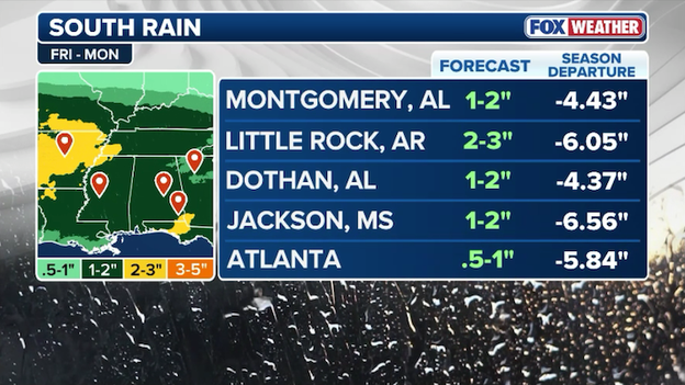
Latest rain forecast from FOX Weather for big cities in the South this holiday weekend.
Big cities in the South are banking on big rain totals from this weekend's storm. Widespread 1-4 inch rain totals are expected, with some localized areas getting as much as 6" of rain.
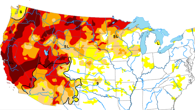
It's welcome rain for cities that are experiencing worsening drought conditions with rain deficits nearing 7 inches in some places.
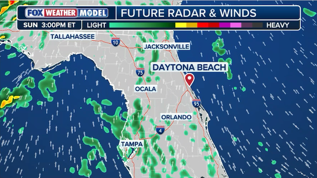
Exclusive FOX Weather Model showing showers popping up across Florida on Sunday afternoon.
NASCAR organizers are monitoring the forecast closely as a storm system crossing the Southern U.S. takes aim at Central Florida this weekend. While much of Speedweeks has enjoyed pleasant weather, the forecast for Sunday’s 2:30 PM ET green flag has turned increasingly concerning.
Rain is threatening Central Florida and Daytona, Florida, which could trigger massive delays for the huge race. Organizers must make crucial decisions on the timing of the race to avoid those big delays.
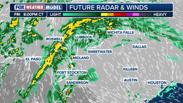
Exclusive FOX Weather Model showing storms firing up on Friday evening across West Texas.
The FOX Forecast Center says storms will start firing up late Friday across West Texas as the Valentine's weekend storm power ups.
New data shows storms initiating over West Texas as early as 7-8 p.m. CT on Friday, advancing eastward through the overnight hours. Widespread severe weather is unlikely, but some of the storms may produce damaging hail.
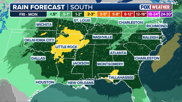
Latest rain forecast from FOX Weather showing the widespread soaking rain expected this weekend in the South.
Latest forecast models confirm a massive 1,000-mile-wide storm system is on track to drop widespread rainfall totals of 1 to 4 inches across a corridor stretching from North Texas to the Carolinas. While the timing is unfortunate for holiday outdoor plans, hydrologists say the steady, drenching nature of this system is exactly what the region needs.
For the drought-stricken South, this weekend’s storm is more than just a holiday washout—it’s a critical lifeline for the nation’s most important waterway. As a massive 1,000-mile-wide system targets the region, the FOX Forecast Center is looking beyond the severe weather threat to the long-term benefit of the expected 1 to 4 inches of rain.
The timing couldn't be more urgent. Current data shows the Mississippi River at Memphis has been languishing at nearly -7.00 feet, flirting with dangerous low-water thresholds.
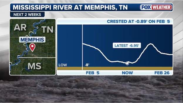
Water levels on the Mississippi River at Memphis, Tennessee are running at nearly -7.00 feet.
To put into perspective, for every foot the river drops, a single barge must be lightened by 5,000 bushels of soybeans to avoid running aground.
Forecasters predict a slow rise in the coming days, but warns that while this rain is heavier in the Delta, it will take a more active pattern to pull the river back to normal levels permanently.
The soaking is especially vital for Northeast Louisiana and North Mississippi, where "Extreme" (D3) drought conditions have taken hold. Much of the South has been running 25-50% below normal precipitation recently.
This weekend's rain will help prime the soil, though experts note that parched ground often absorbs the moisture before it can run off into the river system.
While the storm brings a risk of flash flooding in urban areas like Memphis and Little Rock, hydrologists say the "steady, drenching" nature of this system is exactly what the Mississippi River Basin needs to help stabilize barge traffic and lower freight costs for American farmers.
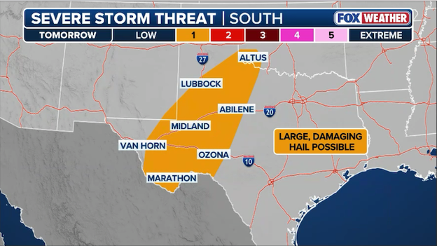
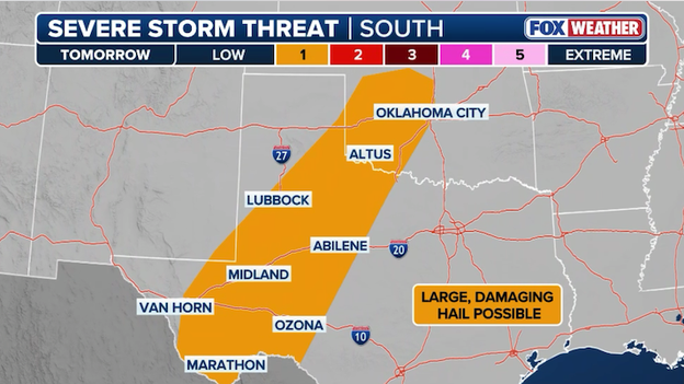
Severe storms could pop across West Texas on Friday night and drop large hail on the Lone Star State.
A few severe storms are expected across portions of Western Texas this Friday night as the Valentine's weekend storm kicks off.
An approaching upper-level trough will clash with unseasonably warm air and surging Gulf moisture. High temperatures reaching the low 70s will create instability across the Trans-Pecos and Permian Basin, setting the stage for scattered thunderstorms to ignite after sunset.
While most activity is expected to remain "elevated" due to nighttime stabilization, strong wind profiles and steep lapse rates suggest that any organized storms could quickly become supercells capable of producing 1-inch (quarter-sized) hail and localized damaging wind gusts.
As the night progresses, a strengthening low-level jet will help push these showers and thunderstorms eastward into Central and Northwest Texas.
While the severe storm threat is expected to diminish slightly as the storms move toward the I-35 corridor, people in cities like Abilene and San Angelo should remain alert for small hail and frequent lightning through the pre-dawn hours of Saturday.
This initial Friday night surge is just the opening act for a wetter Saturday, where the focus will shift toward a broader threat of drenching rain and isolated strong storms across the heart of the Lone Star State.
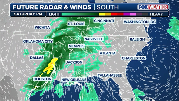
Strong or severe thunderstorms could pop up across Texas on Saturday.
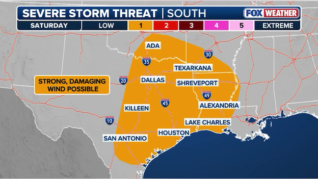
Damaging winds are set to break more than spirits in Dallas & Houston this Valentine's Day. The FOX Forecast Center is tracking a potent storm system that could interrupt Valentine's Day plans in North and Southeast Texas.
Strong thunderstorms could plow through the state during the afternoon and evening hours. While the risk of a widespread severe weather outbreak is low, damaging straight-line winds could easily knock over patio furniture or snap weak tree limbs during outdoor dates.
The 2026 Valentine’s Day weekend is bringing more than just rain to the South; it’s delivering a classic clash of seasons that could trigger severe weather.
As a powerful upper-level disturbance carves through the central Plains, it is expected to ignite a line of strong to severe thunderstorms Saturday that will sweep from East Texas and Oklahoma into the lower Mississippi Valley.
The action heats up Friday night over West Texas where elevated storms could drop big hail on the Lone Star State late in the evening and into the overnight hours. From there, a line of storms is predicted to form farther east and sweep through the Southeast.
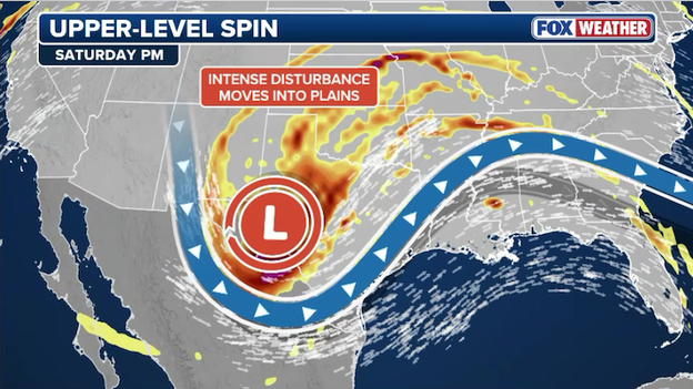
A powerful upper-level disturbance will charge through the South, setting the stage for strong thunderstorms.
FOX Weather meteorologists say the primary driver behind this threat is a surge of unseasonably warm, humid air—affectionately dubbed "February Fire" by forecasters—with temperatures climbing into the low-to-mid 70sF. This moisture-rich Gulf air acts as high-octane fuel for the atmosphere, creating the instability needed for intense updrafts.
When this fuel meets the sharp cold front and the subtropical jet stream overhead, the resulting vertical wind shear can cause storms to rotate, increasing the risk for organized severe weather.
Current analysis indicates that Saturday's storms will carry a "menacing edge," with damaging wind gusts up to 60 mph being the primary concern as thunderstorms organize into several fast-moving squall lines.
While widespread severe storms don't appear likely now, meteorologists warn the ingredients could support a couple tornadoes and deadly lightning, particularly across Louisiana, Arkansas, and western Mississippi.
Lovers with outdoor Valentine’s plans are urged to have a backup plan ready, as the risk for these powerful storms is expected to peak during the late afternoon and evening hours.
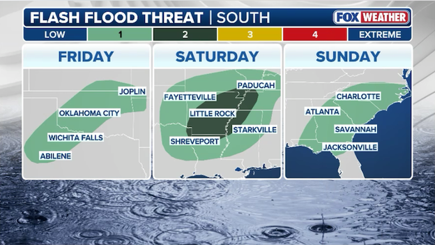
Flash flooding will be possible from Texas and Oklahoma to the Carolinas over the holiday weekend.
A multi-day flash flood threat is developing across the South, beginning Friday in the Southern Plains and extending through Tennessee by the weekend. As a powerful storm system tracks from the Southwest, it will tap into moisture-rich Gulf air to produce widespread rain totals of 1 to 4 inches, with localized areas potentially reaching 6 inches. These high rain rates are particularly concerning for urban areas and low-lying neighborhoods where "training" storms may repeatedly pass over the same locations.
The threat level has increased specifically for the Ark-La-Tex region on Saturday, with heavy rain expected to spread quickly into Mississippi, Alabama, and Tennessee. While much of this moisture will be beneficial for drought-stricken areas in Arkansas and Georgia, the intensity of the downpours could quickly overwhelm small streams and drainage systems.
You can go back and see live updates from Wednesday's coverage.
Click here to see the minute-by-minute updates from FOX Weather.
You’ve reached the beginning of this live coverage.