Cold air invades US to start November
Colder-than-average temperatures are expected to continue in the eastern states through this weekend
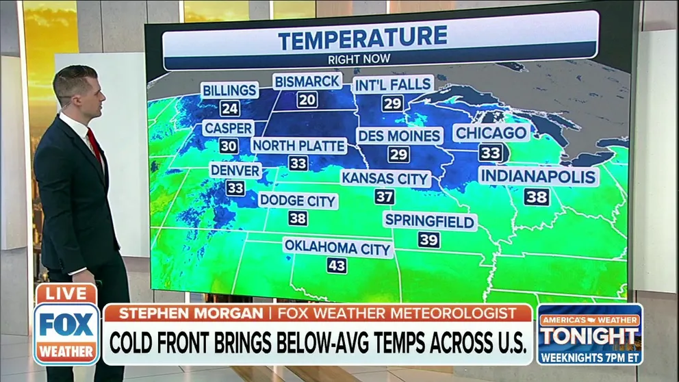
Cold front brings below average temperatures across U.S.
A cold front is bringing below average temperatures across the U.S.
The final month of fall is beginning on a chilly note as the coldest air so far this season spreads across the United States this week.
Many cities east of the Mississippi River endured one of their warmest Octobers on record, but much colder temperatures have now replaced that mild air.
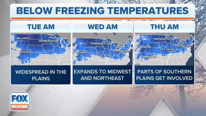
Tracking the below-freezing temperatures this week.
(FOX Weather)
Temperatures will dip to 15 to 25 degrees below average Tuesday in the Central and Southern Plains, yielding highs in the 40s as far south as Oklahoma and the Texas Panhandle.
Farther north and east, highs will be in the 40s and 50s from the Northern Plains to the Midwest, Ohio Valley and New England and southward into the mid-Atlantic, Tennessee Valley and mid-South. These temperatures and generally 5 to 15 degrees colder than average for early November.
NOVEMBER FORECAST TO BE WARMER THAN AVERAGE IN NORTHEAST AND ROCKIES, NOAA SAYS
Minneapolis/St. Paul is in the middle of its coldest stretch of weather since April 19-21, when highs were stuck in the lower 40s on three straight days.
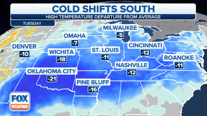
Forecast highs compared to average on Tuesday, Nov. 2, 2021.
(FOX Weather)
The chilly air will expand even farther south and east by Wednesday. High temperatures will be stuck in the 40s and 50s from North Texas to the western Carolinas, as highs struggle to get out of the 40s across the Texas Panhandle, Oklahoma, Arkansas, northern Mississippi, western Tennessee, Missouri and Kansas.
Temperatures will also be in the 40s Wednesday across the entire northern tier of the nation from the Northern Plains to the Midwest, Ohio Valley and interior Northeast, with the 50s expected along the Interstate 95 corridor.
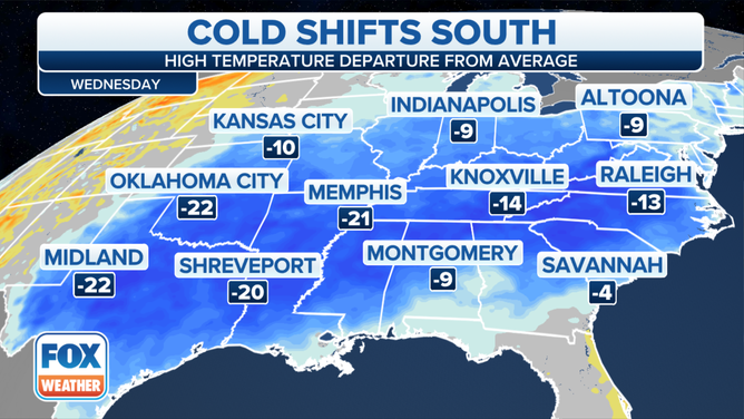
Forecast highs compared to average on Wednesday, Nov. 3, 2021.
(FOX Weather)
On Thursday, the core of the colder-than-average temperatures will settle across the nation's southern tier. Highs will be 10 to 20 degrees below average from the Southern Plains to the Southeast, translating to temperatures mainly in the 50s, with any 60-plus-degree highs confined to areas along the Gulf Coast.
If Houston fails to reach 60 degrees on Thursday, it will be the first high in the 50s there since Feb. 19 (51 degrees).
OCTOBER 2021 WAS WARMEST, WETTEST ON RECORD FOR SEVERAL CITIES IN CENTRAL, EASTERN U.S.
In the Midwest and Northeast, highs will mainly be in the 40s on Thursday, though a few spots along the coast or farther south into the mid-Atlantic may reach the lower 50s.
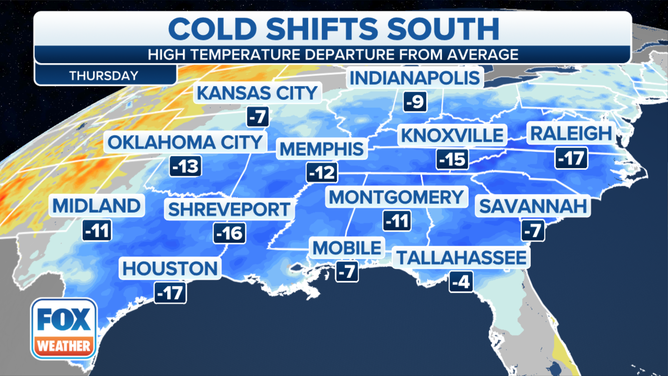
Forecast highs compared to average on Thursday, Nov. 4, 2021.
(FOX Weather)
Low temperatures will dip below freezing in many areas the next several mornings.
The National Weather Service has issued Freeze Warnings and Frost Advisories from East Tennessee and parts of the Ohio Valley into the mid-Atlantic and southern Connecticut. Freeze Watches are also posted farther west into parts of the mid-Mississippi Valley.
HERE'S WHEN TO EXPECT YOUR FIRST FREEZE OF THE SEASON
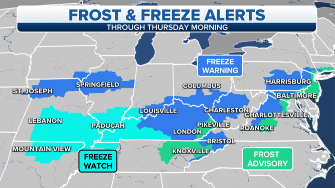
Frost and freeze alerts are issued by the National Weather Service.
(FOX Weather)
Wednesday morning, lows will fall into the 20s across the Northern Plains, upper Midwest and Ohio Valley.
Much of the Northeast and mid-Atlantic will dip into the 30s Wednesday morning. The highest risk of subfreezing temperatures will be north and west of Interstate 95, but patchy frost is still possible to the south and east. Regardless, it will be the coldest morning of the season for the majority of this region.
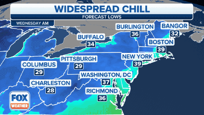
Forecast low temperatures Wednesday morning, Nov. 3, 2021.
(FOX Weather)
Frosts and freezes will remain a risk Thursday morning from the Northern and Central Plains to the mid-Atlantic and Northeast.
WHEN CAN YOU EXPECT THE FIRST SNOW OF THE SEASON?
In fact, Thursday morning might end up a few degrees colder than Wednesday morning in New England and New York state. Most other areas will likely have similar temperatures both mornings.
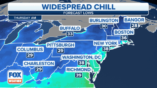
Forecast low temperatures Thursday morning, Nov. 4, 2021.
(FOX Weather)
While the Northern and Central Plains and the upper Midwest will see a warming trend later this week, the colder-than-average temperatures are expected to continue in the eastern states through the weekend.