Mudslide blocks railroad tracks in New York as rain soaks Northeast
The incident occurred as New York City was experiencing its seventh consecutive wet weekend, according to the FOX Forecast Center. The Big Apple has received more rain since Aug. 1 than Seattle has for the entire year.
Coastal storm pulls away from Northeast with lingering rain, wind
As a coastal storm departs, lingering rain will be heavy at times and gusy winds are the primary concern. Higher elevations could see some snow as cool air moves in behind the storm.
NEW YORK – The soggy stretch conditions on Sunday for the Northeast as a coastal storm continues to bring rain throughout most of the region after causing impacts to rail travel this weekend.
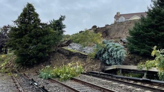
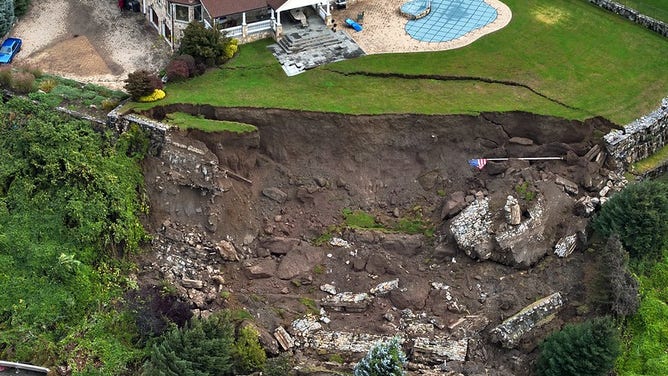
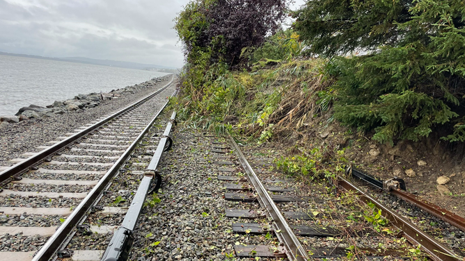
Railway service in New York was suspended between New York City and Albany on Saturday as heavy rain triggered a mudslide that covered several tracks.
Metro-North said the Hudson Line between Croton-Harmon and Tarrytown is the affected service area. Officials tweeted an image showing an embankment that collapsed and covered several tracks in dirt, debris and uprooted trees.
New York Gov. Kathy Hochul said that no injuries have been reported because of the incident and that no passengers are stranded.
"Our top priority is to restore service as quickly as possible so the Monday morning commute can occur as normal," Hochul said in the tweet.
![Mudslide covers railroad tracks along the Metro North Railroad. Oct. 21, 2023.]() Image 1 of 4
Image 1 of 4Mudslide covers railroad tracks along the Metro North Railroad. Oct. 21, 2023. (@MetroNorth / X)
![New York mudslide]() Image 2 of 4
Image 2 of 4Mudslide disrupts train traffic between NYC and Albany (Metropolitan Transportation Authority)
![New York mudslide]() Image 3 of 4
Image 3 of 4Mudslide disrupts train traffic between NYC and Albany (Metropolitan Transportation Authority)
![New York mudslide]() Image 4 of 4
Image 4 of 4Mudslide disrupts train traffic between NYC and Albany (Metropolitan Transportation Authority)

Amtrak's service out of New York City was also impacted, with operators temporarily suspending service between the Big Apple and Albany.
The incident occurred as New York City was experiencing its seventh consecutive wet weekend, according to the FOX Forecast Center. The Big Apple has received more rain since Aug. 1 than Seattle has for the entire year.

(FOX Weather)
This weekend's rain is the result of a coastal storm riding up the coast as a robust area of low pressure brings heavy rain and powerful winds to the Northeast, which will linger into Monday for residents in New England.
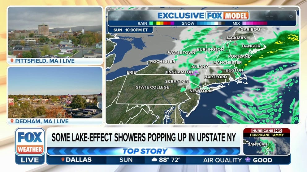
Sunday forecast

(FOX Weather)
Conditions are expected to improve early Sunday for the Northeast as the low moves farther north, the FOX Forecast Center noted.
However, the latest forecast models indicate this low will be slow to leave the region, resulting in more showers and low clouds hugging the coast to close out the weekend.
By Sunday night, between 1 and 3 inches of rain is forecast to have fallen for most of New England, with parts of Vermont, New Hampshire and Maine receiving 2 to 3 inches of rain.
6 TYPES OF CLOUDS YOU MIGHT SEE DURING SEVERE STORMS
As the rain lets up, gusty winds are possible throughout Sunday across the Northeast. New York City is forecast to see gusts between 30 and 40 mph, and Baltimore and Pittsburgh face gusts between 20 and 30 mph.

(FOX Weather)
Monday
The rain and wind will linger in New England through Monday, according to the FOX Forecast Center.

(FOX Weather)
Monday morning will be a cold start at the school bus stop for areas farther inland.
Frost and freeze alerts are in effect through Monday morning for all of Ohio, parts of western Pennsylvania, eastern Indiana, western Virginia, West Virginia, eastern Kentucky and northeastern Tennessee. Scattered frost is possible as temperatures dip near freezing late Sunday night and early Monday.

(FOX Weather)
CAN JOINT PAIN REALLY HELP YOU PREDICT THE RAIN?
This week will feature a more stable atmosphere over the East, leading to a drier and more comfortable weather pattern – great news for anyone who has outdoor activities or travel planned.