Coast-to-coast storm to bring snow, severe storms and strong winds to Plains, Midwest ahead of Veterans Day
A foot or more of snow is possible in parts of northeastern North Dakota and northern Minnesota
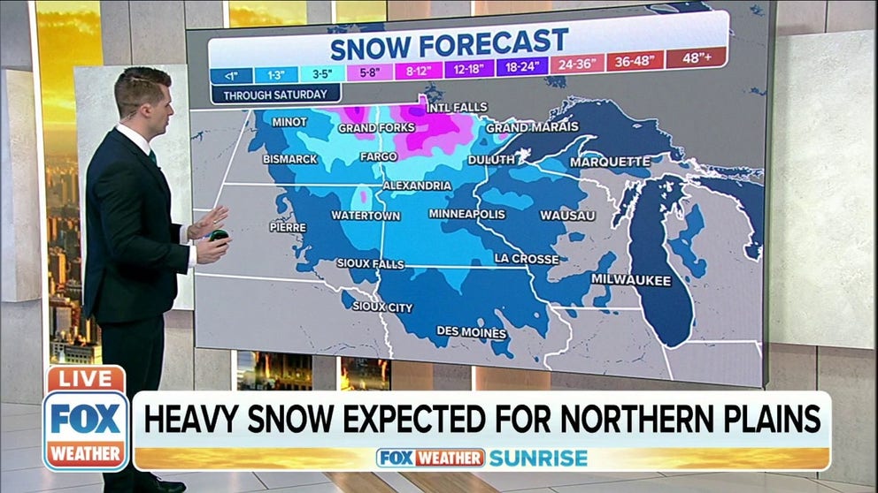
Heavy snow expected for Northern Plains
Heavy snow is expected for the Northern Plains through Saturday.
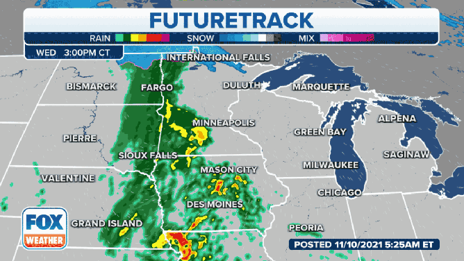
A powerful storm system sweeping across the United States ahead of Veterans Day will bring snow, rain, severe thunderstorms and strong winds to the Plains and Midwest starting Wednesday before spreading into the eastern U.S. late this week.
The system first crashed ashore along the West Coast Monday night and triggered a rare Tornado Warning for the Seattle area Tuesday.
This powerful storm will now emerge over the Plains on Wednesday, setting the stage for an active day of weather across the central U.S., with parts of the Midwest and South then getting involved Wednesday night into Veterans Day. The system will eventually conclude its cross-country trek Friday night as it pushes off the East Coast.
A powerful storm will emerge over the Plains and Midwest ahead of Veterans Day.
(FOX Weather)
Much colder air will follow in the wake of this storm across the central and eastern U.S. after an unseasonably warm start to the week.
TEMPERATURES TO PLUMMET IN EASTERN HALF OF U.S. AS WEEKEND NEARS
Snow and rain impacts
While many areas will see a soaking rain with this system, parts of the Northern Plains and upper Midwest could see their first significant snowfall of the season Thursday into Friday.
The National Weather Service has issued a Winter Storm Watch for northeastern South Dakota from Thursday evening through Friday afternoon. Additional watches and warnings will likely be issued for other parts of the Northern Plains and upper Midwest later Wednesday.
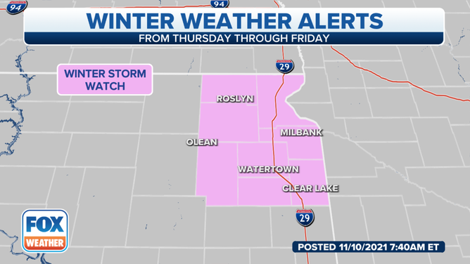
A Winter Storm Watch is in effect for the pink-shaded area.
(FOX Weather)
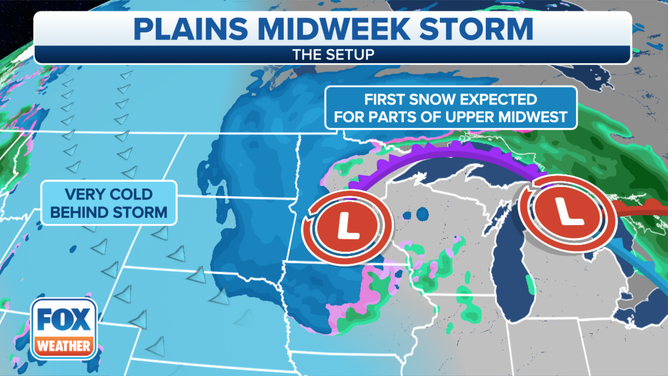
Precipitation will likely begin as rain, but colder air will quickly rush in and change the rain over to snow starting in northeastern North Dakota Wednesday morning and afternoon, then in northern Minnesota Wednesday night.
On Veterans Day, snow will continue in northern Minnesota, while a second batch of snow develops back to the west over North Dakota as much colder temperatures build in on the backside of this storm.
(FOX Weather)
Thursday night, snow will fall across central and eastern North Dakota, eastern South Dakota and northern and western Minnesota. The snow should gradually taper off in the eastern Dakotas through the day Friday, with lingering snow showers possible in Minnesota into Friday evening. Rain could mix with snow on Friday over parts of Iowa, Wisconsin and northern Illinois before ending Friday night.
Lake-effect rain and snow showers will then develop downwind of the Great Lakes this weekend with the colder air in place.
The heaviest snow is predicted to fall across northeastern North Dakota and northern Minnesota, where many areas could pick up 6 to 12 inches of snow. Isolated spots in this region might receive more than a foot of snow.
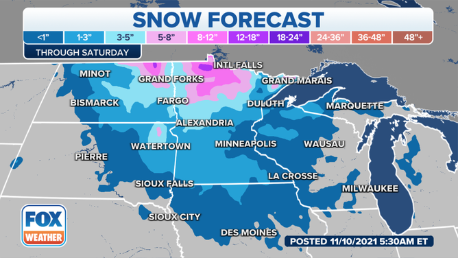
Snowfall forecast through Saturday, Nov. 13, 2021.
(FOX Weather)
Less than a half-foot of snow is forecast for other parts of the Northern Plains and upper Midwest. Minneapolis/St. Paul is only projected to see an inch or less, but it's still notable because it will be the first snow of the season for the Twin Cities.
This system will also spread a line of heavier rain and a few strong thunderstorms across the South and the Mississippi, Ohio and Tennessee valleys Thursday into Thursday night.
On Friday, the strong line of rain and thunder will move through the eastern U.S. from New England to North Carolina before the storm pushes off the East Coast Friday night.
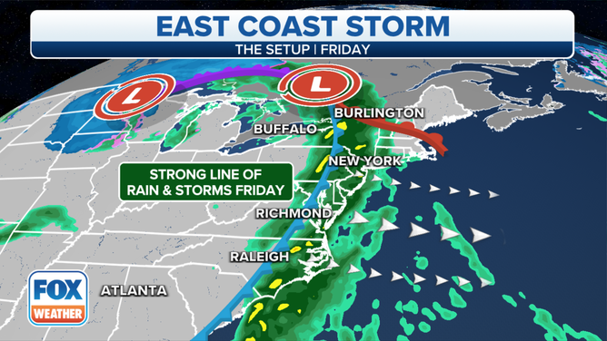
A strong line of rain and thunderstorms will move through the eastern U.S. Friday, Nov. 12, 2021.
(FOX Weather)
Wind impacts
Gusty winds will accompany the snow and rain in the Plains and Midwest starting on Veterans Day.
A High Wind Watch has been posted for north-central Nebraska on Thursday, and the NWS will likely issue additional alerts for high winds in other parts of the Northern Plains and upper Midwest in the next day or so.
The highest winds on Veterans Day will target the Northern Plains, where widespread gusts of 30 to 50 mph are likely from the Dakotas to Nebraska. Gusts to 30 mph are possible farther east over the upper Midwest.
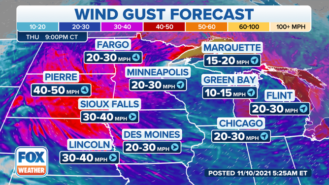
Wind gust forecast Thursday, Nov. 11, 2021.
(FOX Weather)
On Friday, winds are forecast to be even stronger across much of the Northern Plains and upper Midwest. Winds could gust from 50 to 60 mph in portions of the Dakotas and Nebraska, with 40- to 50-mph gusts possible farther east into parts of western Minnesota, Iowa and Illinois.
In places where snow is falling, these high winds will lead to blowing and drifting snow and possible blizzard conditions, meaning visibility could be reduced to near zero at times. This is especially hazardous for motorists, so you're advised to use extreme caution if you must travel on Veterans Day or Friday.
WHAT YOU SHOULD KNOW ABOUT BLOWING, DRIFTING SNOW
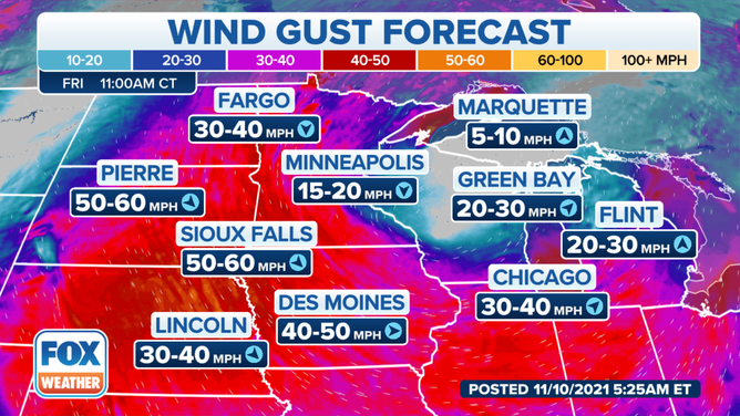
Wind gust forecast Friday, Nov. 12, 2021.
(FOX Weather)
Severe thunderstorm impacts
The southern end of this storm's cold front will sweep across the Southern Plains and mid-Mississippi Valley on Wednesday.
As a result, scattered severe storms are predicted to develop over parts of North Texas, Oklahoma, eastern Kansas, western Missouri and western Arkansas Wednesday afternoon through Wednesday evening. The greatest risk will be over North Texas and central and eastern Oklahoma, including Dallas/Fort Worth and Oklahoma City.
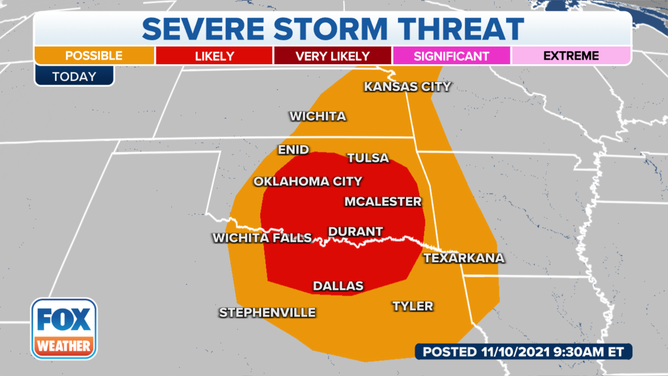
Severe thunderstorm threat Wednesday, Nov. 10, 2021.
(FOX Weather)
Large hail and damaging wind gusts are the main threats – but a few tornadoes are also possible, especially near the Texas/Oklahoma border.
SEVERE STORMS THREATEN TEXAS, OKLAHOMA, KANSAS, MISSOURI AND ARKANSAS ON WEDNESDAY
On Thursday, an isolated stronger thunderstorm isn't entirely out of the question as the cold front moves through the South. However, the risk for severe storms is very low because widespread rain will prevent the atmosphere from becoming unstable.