Cross-country storm brings significant weekend severe weather threat to central US, soaking rain to Northeast
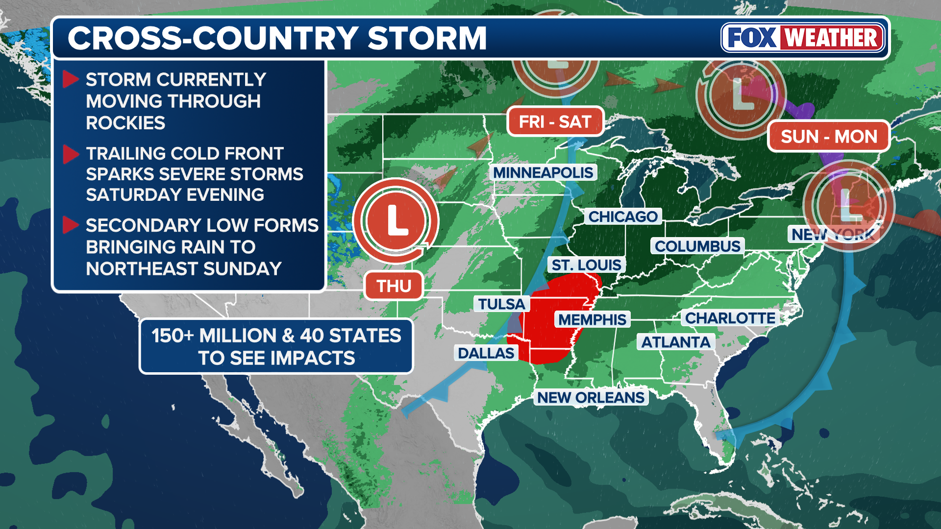
The Midwest will see heavy rain by Friday, while the Ozarks and Mississippi Valley will have to contend with a severe weather threat in addition to the rain before the system reaches the Northeast by Sunday.

Sweeping fall storm to bring severe weather to Central US and heavy rain to Northeast
The cross-country storm moves across the Central U.S. on Friday it will bring an elevated risk of severe storms on Saturday. By Sunday and into early next week, rain associated with this system will spread into the Northeast.
The FOX Forecast Center is monitoring a potent fall cross-country storm that will bring severe weather to the central U.S. and days of heavy rain to the Northeast this weekend and into early next week.
The Midwest will see heavy rain by Friday, while the Ozarks and Mississippi Valley will have to contend with a severe weather threat Saturday in addition to the rain before the system reaches the Northeast by Sunday.
(FOX Weather)
Weekend severe storm threat for central US could bring tornadoes and large hail
The severe weather system is expected to intensify Friday, first bringing scattered thunderstorms from Oklahoma to northwestern Missouri late Friday afternoon and evening, while bringing a more significant afternoon threat to the Ark-La-Tex region, the Ozarks and the Mississippi Valley on Saturday.
Tornadoes, damaging winds and large hail are all possible, though the exact intensity of thunderstorms on Friday and Saturday will be determined by the amount of daytime heating.

(FOX Weather)
Higher afternoon temperatures will increase the strength of the storms later in the day and evening.
A large swath of the country from Texas to Ohio will face this severe weather threat Saturday. Be sure to check the FOX Weather app for the latest details.
In addition to the modes of severe weather, the heavy rain will create a Level 2 out of 4 flash flood risk Saturday covering parts of northwest Arkansas, Missouri, including St. Louis, and southwestern Illinois.
The National Weather Service office in St. Louis noted that the city had only tallied 0.78 inches of rain between Aug. 18 and Oct. 15, the second driest such stretch in the last 150 years.

(FOX Weather)
Northeast to see days of heavy rain on the heels of nor'easter
By Sunday afternoon, the cold front will make its way into the Ohio Valley and interior Northeast, with places like Buffalo, New York, and Pittsburgh, Pennsylvania, facing periods of moderate rainfall to close out the weekend.
A low-end flash flood risk covers western Pennsylvania, West Virginia and Ohio on Sunday.
The rain is forecast to intensify Sunday night, reaching the heavily populated Interstate 95 corridor in time for the Monday morning commute.

(FOX Weather)
Heavy rain is expected to persist through early Tuesday, with widespread rain totals of 1-2 inches across the Northeast and northern New England and localized amounts of 2-3 inches of rain possible.
In addition, while the main area of low pressure responsible for the wet weather begins to lift into Canada Tuesday, computer forecast models suggest that another area of low pressure may develop, and soggy conditions could linger across parts of New England into midweek.