Celia could become a hurricane later this week as it parallels Mexico’s western coast
While all is quiet in the Atlantic, the Eastern Pacific is getting ready for another hurricane
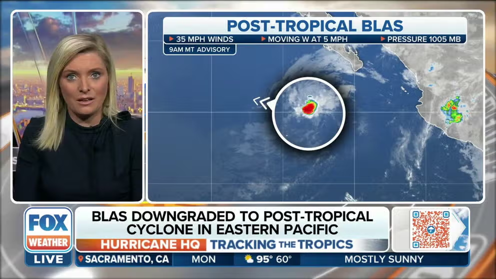
Blas downgraded to Post-Tropical Cyclone in Eastern Pacific
Blas has been downgraded to a Post-Tropical Cyclone in the Eastern Pacific with 35 mph winds.
Celia might have weakened to a tropical depression Friday night, but it's expected to regain tropical storm strength on Tuesday and could even become a hurricane by the end of the week.
As of midday Monday, Celia had maximum sustained winds of only 30 mph and was located more than 300 miles south of Salina Cruz, Mexico. The tropical depression was moving west-southwestward at 8 mph.
HOW TO WATCH FOX WEATHER ON TV

(FOX Weather)
The National Hurricane Center expects Celia to begin a gradual strengthening trend by early Tuesday, likely becoming a tropical storm Tuesday afternoon or evening.
Celia will move generally westward for the next day or two before making a turn toward the west-northwest by midweek.
Current projections by the NHC indicate Celia will strengthen into a hurricane late Thursday or early Friday as it stays well offshore but moves parallel to the western coast of Mexico.
HOW ARE HURRICANES RATED? THE SAFFIR-SIMPSON HURRICANE WIND SCALE EXPLAINED
The storm is not expected to bring any impacts to land, but Celia will be a hazard for any ships passing through this area of the Eastern Pacific.

(FOX Weather)
To the northwest of Celia, Blas, a hurricane last week, has fallen apart and is now simply a remnant area of low pressure several hundred miles off Mexico's western coast.
The system should dissipate over the open waters of the Eastern Pacific by Wednesday.
HERE’S HOW TO PREPARE FOR HURRICANE SEASON NOW

(FOX Weather)
Atlantic
Meanwhile, the tropics are on snooze in the Atlantic this week. No areas are being monitored for potential development over the next five days.
Saharan dust traveling from western Africa across the tropical Atlantic, Caribbean Sea and Gulf of Mexico will continue to inhibit tropical development in the near-term future.
5 THINGS TO KNOW ABOUT THE SAHARAN DUST PLUME

(FOX Weather)
What you will see instead of tropical storms and hurricanes are colorful sunrises and sunsets as the dust scatters the sun's rays.
WHEEZING AND SNIFFLING? IT COULD BE SAHARAN DUST
CLICK HERE TO GET THE FOX WEATHER UPDATE PODCAST
FOX Weather Hurricane Specialist Bryan Norcross has a podcast, Tracking the Tropics with Bryan Norcross, available now on FOX News Audio. You can download it on your device by clicking here.