Category 6 needed on hurricane wind scale due to warming climate, study says
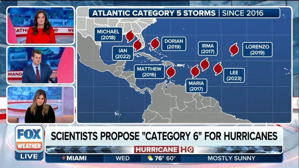
Since 1980, half of the 197 tropical cyclones rated a Category 5 happened within the past 17 years. Five of the storms would have met the hypothetical Category 6, according to the study.
Scientists propose 'Category 6' for hurricanes
FOX Weather meteorologists discuss the new study suggesting the need for an additional category on the Saffir-Simpson Hurricane Wind Scale.
Amid warming oceans and increasing rapid intensification of tropical cyclones, a new study suggests expanding the hurricane wind scale to include a Category 6 with winds over 192 mph.
Climate researchers published a study in the Proceedings of the National Academy of Sciences journal that considers adding a Category 6 to the long-used Saffir-Simpson Hurricane Wind Scale due to more intense tropical cyclones fueled by warming oceans.
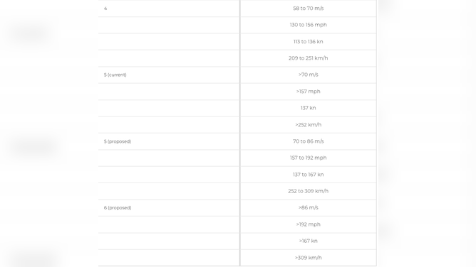
Hurricanes in the Atlantic Basin are assigned a Category 1-to-5 rating based on their maximum sustained winds. This hurricane category method is called the Saffir-Simpson Hurricane Wind Scale, and the National Hurricane Center has used it to evaluate the strength of hurricanes since the early 1970s. It’s the most used metric the public recognizes but does not extend beyond a Category 5 storm with winds topping out at 157 mph or stronger.
The study authors say because the scale is open-ended, it can lead to the public underestimating the risk of a storm, which is becoming increasingly problematic with warming oceans fueling rapid intensification.
WHAT DOES IT MEAN WHEN A HURRICANE UNDERGOES 'RAPID INTENSIFICATION'?
According to the National Hurricane Center, rapid intensification occurs when a tropical cyclone's maximum sustained winds increase by at least 35 mph in a 24-hour period. Another MIT-led study found that rapid intensification rates are expected to become more common because of climate change.
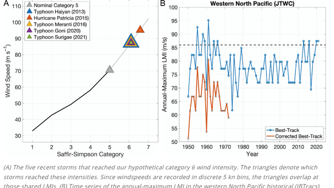
A chart showing five recent storms that would meet the hypothetical category 6 wind intensity.
(MIT)
After looking at hurricanes between Category 3 and 5 over the past 42 years, the study authors said they found half of the 197 tropical cyclones rated a Category 5 happened within the past 17 years.
Five of the storms would have met the hypothetical Category 6, including Typhoon Haiyan, which made landfall in the Philippines in 2013, killing more than 6,300 people. The study also included Hurricane Patricia as one of the five storms to meet this proposed new wind category. The 2015 monster storm with winds topping out at 207 mph.

View of a building partially destroyed after the passage of Hurricane Otis in Acapulco, Guerrero State, Mexico, on October 26, 2023.
(RODRIGO OROPEZA/AFP / Getty Images)
During the 2023-2024 hurricane season, after undergoing rapid intensification and jumping from Category 1 to monster Category 5, Hurricane Otis made landfall in Mexico with winds topping 165 mph – the strongest landfall on record for Mexico. The storm went from 50 mph to 165 mph within 24 hours.
The proposed hurricane wind scale includes a new Category 6.
According to the new study, Otis would have been included under the proposed Category 5, which would start at 157 mph and top out at 192 mph. The proposed Category 6 would be anything with maximum winds of 192 mph.
TOP 5 COSTLIEST HURRICANES IN US HISTORY
During the 2022-2023 season, Hurricane Idalia strengthened by 45 mph in 24 hours, which is the fourth most extreme rapid intensification of any storm making landfall in the U.S.
The study authors argue that adding the 6th category of the Saffir-Simpson Hurricane Wind Scale would better communicate a changing climate with more intense tropical cyclone winds.
In response to a request from FOX Weather about the new study, NHC Director Michael Brennan provided this statement.
"At NHC, we've tried to steer the focus toward the individual hazards, which include storm surge, wind, rainfall, tornadoes and rip currents, instead of the particular category of the storm, which only provides information about the hazard from wind. Category 5 on the Saffir-Simpson scale already captures ‘Catastrophic Damage' from wind, so it's not clear that there would be a need for another category even if storms were to get stronger. In addition, most deaths in tropical cyclones occur not from the wind but from water - storm surge, rainfall/inland flooding, and hazardous surf - causing about 90 percent of tropical cyclone deaths in the United States. So, we don't want to over-emphasize the wind hazard by placing too much emphasis on the category."
The new study comes after the National Hurricane Center recently announced it will be changing the way the forecast cone, also known as the cone of uncertainty, is displayed. The NHC plans to start releasing an experimental forecast cone that will show all related watches and warnings from local National Weather Services offices and the NHC.