Fast-moving storm spawns tornado in Southern California day after deadly atmospheric river exits
An EF-1 tornado moved across parts of Southern California on Wednesday. Heavy rain and thunderstorms are forecast to continue on Thursday.
More rain for flood ravaged LA
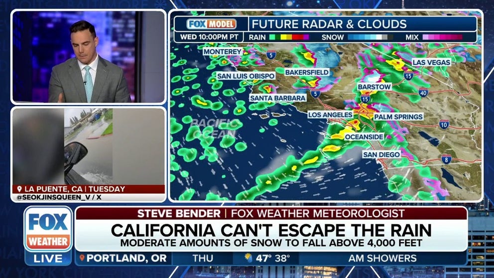
Another storm is making its way through California bringing Los Angeles even more rain after getting half-a-year of rain in just days with the atmospheric river.
LOS ANGELES – Just one day after a deadly atmospheric river storm moved out of California and made its way to the east and impacted the Las Vegas area, where preparations are underway for Super Bowl LVIII, another storm swept through the Golden State with additional rain, mountain snow and even a tornado.
This storm was less intense than the one that just brought destructive wind gusts and torrential rain, but the additional rain was an unwelcome sight for those tasked with the ongoing cleanup efforts in the wake of the multiday atmospheric river.
DRONE VIDEO SHOWS CALIFORNIA CLIFF ERODING AFTER ATMOSPHERIC RIVER POUNDS SANTA BARBARA AREA

(FOX Weather)
Even though the storm’s trajectory from the north cut off any tropical moisture connection, keeping it from becoming yet another atmospheric river, unstable air triggered strong thunderstorms that produced a tornado in Southern California's Grover Beach.
"EF-1 Tornado confirmed in Grover Beach," Five Cities Fire PIO said on X on Thursday afternoon. The department says they worked with police and the NWS Los Angeles to survey the damage and storm path.
![]() Image 1 of 4
Image 1 of 4Tornado reportedly caused damage in Grover Beach, CA, on Wednesday. (Teri Kathary/Facebook)
![]() Image 2 of 4
Image 2 of 4Tornado reportedly caused damage in Grover Beach, CA, on Wednesday. (Teri Kathary/Facebook)
![]() Image 3 of 4
Image 3 of 4Tornado reportedly caused damage in Grover Beach, CA, on Wednesday. (Teri Kathary/Facebook)
![]() Image 4 of 4
Image 4 of 4Tornado reportedly caused damage in Grover Beach, CA, on Wednesday. (Teri Kathary/Facebook)


Photos from Grover Beach show several areas of damage, including toppled trees, strewn debris and some damage to buildings, but there are no reports of any injuries.
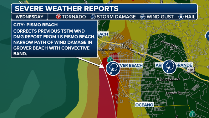
The severe weather report on Wednesday, Feb. 7, 2024.
(FOX Weather)
The fast-moving storm system was already pushing most of its rain out into the eastern deserts by Wednesday night with just lingering showers forecast Thursday. The Los Angeles area generally saw rain totals from 0.20 to 0.40 inches Wednesday on top of the more than 8 inches that fell during the three-day atmospheric river. Santa Ana's John Wayne Airport set a daily rain record Wednesday with 0.40 inches.
FLOOD WATCH, WARNING AND EMERGENCY: HERE ARE THE DIFFERENCES THAT COULD SAVE YOUR LIFE
There has also been additional snowfall in the higher elevations of the Sierra Nevada, where some locations picked up several feet of fresh powder over the past few days.
The FOX Forecast Center expects about a foot of additional snow with some locally higher totals from this latest storm system.
WATCH: BALD EAGLE MOTHER BRAVES POWERFUL ATMOSPHERIC RIVER TO PROTECT HER EGGS FROM SNOW, WIND RAIN

(FOX Weather)
The end of the extreme weather is near, though. The FOX Forecast Center said much drier conditions are expected to return to the region on Thursday and last through at least the weekend.